Sherburne Complex Wildlife Management Area facts for kids
Quick facts for kids Sherburne Complex |
|
|---|---|
|
IUCN Category IV (Habitat/Species Management Area)
|
|
| Location | Iberville / St. Martin Parishes, Louisiana |
| Nearest city | Krotz Springs, Louisiana |
| Established | 1996 |
| Governing body | Louisiana Department of Wildlife and Fisheries, U.S. Fish and Wildlife Service, U.S. Army Corps of Engineers |
| Website | Sherburne Complex Wildlife Management Area |
The Sherburne Complex is a special natural area in Louisiana. It's managed by three groups working together: the U.S. Fish and Wildlife Service, the Louisiana Department of Wildlife and Fisheries (LDWF), and the U.S. Army Corps of Engineers. This teamwork started in 1983. The complex covers about 44,000 acres (178 square kilometers). The Louisiana Department of Wildlife and Fisheries helps manage it.
You can find the Sherburne Complex in the Morganza Floodway system, which is part of the Atchafalaya Basin. It's about 30 miles (48 km) west of Baton Rouge, Louisiana. The area stretches from just north of old Highway 190 to a bit south of I-10. The closest town is Krotz Springs, located to the north.
Contents
History of the Sherburne Complex
The Atchafalaya Basin is a large, swampy area near the Mississippi River. Over time, big floods in the Mississippi River area led to the creation of places like the Sherburne Complex. After a huge flood in 1927, the state of Louisiana passed laws to control floods. These laws helped create the Atchafalaya Basin Floodway system.
In the 1930s and 1940s, a lot of digging was done in the Atchafalaya River to help water flow better. In 1963, a special structure called the Old River Control Structure was built. This was to stop the Mississippi River from changing its main path into the Atchafalaya River.
By 1968, people started worrying more about the environment. Because of this, and a lack of money, the digging work stopped. In 1982, a big plan for the Atchafalaya Basin was finished. This plan was called the "Atchafalaya Basin Floodway System Project." In 1983, the state bought 10,232 acres (41.4 square kilometers) to create the Sherburne Wildlife Management Area.
Working Together for Nature
In 1986, the United States Congress approved a lot of money for the Atchafalaya Basin Program. This showed that the area was important for the whole country. Governor Foster asked the Louisiana Department of Natural Resources to work with the U.S. Army Corps of Engineers. Their goal was to create a "Master Plan" for the Atchafalaya Basin. In 1988, this plan was put into action, and the Sherburne Complex was officially formed.
Exploring the Sherburne Complex
The Sherburne Complex brings together three important areas: the Sherburne Wildlife Management Area (WMA), the Atchafalaya National Wildlife Refuge, and the U.S. Army Corps of Engineers' Bayou Des Ourses. The main goal is to protect and manage all the fish and wildlife in these areas.
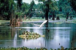
The entire complex is known for its "bottomland hardwoods," which means it has many trees that grow in wet, low-lying areas. You'll find many swamps, lakes, and bayous here. This makes it a great place for learning about nature, doing scientific studies, and enjoying outdoor activities.
The three areas offer many fun things to do. You can find trails for ATVs, two places to camp, a shooting range, and boat launches. There's even a 17-mile (27 km) marked paddling trail. This trail lets visitors explore the bayous by boat without needing a guide. Other activities include birdwatching, watching other animals, hunting, fishing, trapping, and nature photography. All these activities are made easier by roads that can be used in all kinds of weather.
Sherburne Wildlife Management Area
The Louisiana Department of Wildlife and Fisheries owns 11,780 acres (47.7 square kilometers) of the Sherburne WMA. The main office is about 3 miles (4.8 km) south of Krotz Springs. This office is located where the old logging town of Sherburne used to be. That town existed from the 1880s to the 1930s. It disappeared after all the trees were cut down.
Atchafalaya National Wildlife Refuge
This part of the complex is a National Wildlife Refuge that covers 15,220 acres (61.6 square kilometers). It was created in 1986. The word "Atchafalaya" comes from the Choctaw Native American language. It means "long river."
If you are older than 16 or younger than 60 and want to use these wildlife areas in Louisiana, you usually need to buy a Wild Louisiana Stamp, a hunting license, or a fishing license. You can also pay a small daily fee.
Bayou Des Ourses
The U.S. Army Corps of Engineers owns 17,000 acres (69 square kilometers) of this area. "Bayou Des Ourses" means Bayou of the Bears in French. It is located across the Atchafalaya River from another large area of Corps land called Indian Bayou.
The Atchafalaya Basin: A Natural Wonder
The Sherburne Complex is just one part of the larger Atchafalaya Basin. This basin is the biggest river swamp in the United States, covering almost one million acres (4,000 square kilometers). It starts near Simmesport and stretches about 140 miles (225 km) south to the Gulf of Mexico.
The basin is home to an amazing variety of wildlife. You can find about 60 different kinds of reptiles and amphibians here. More than 250 types of birds live in this rich area, including the American bald eagle and the peregrine falcon. Many other animals and nearly 100 different kinds of fish and water creatures also call the Atchafalaya Basin home.
Oil and Gas in the Area
The Sherburne Complex area also has many gas pipelines. Some of these are called Gulf Central Pipeline, Dixie Pipeline, and Dow Pipeline. There are also oil wells located in the area.
Major Floods in History
- Great Flood of 1844
- Flood of 1851
- Great Flood of 1951
- Great Flood of 1993
 | Frances Mary Albrier |
 | Whitney Young |
 | Muhammad Ali |


