Silver Island Range facts for kids
Quick facts for kids Silver Island Range |
|
|---|---|

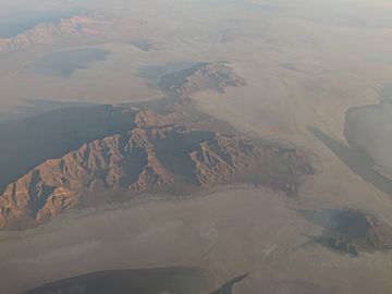
Aerial view
|
|
| Highest point | |
| Peak | Graham Peak |
| Elevation | 7,563 ft (2,305 m) |
| Dimensions | |
| Area | 55.2 sq mi (143 km2) |
| Geography | |
| Country | United States |
The Silver Island Range, also known as the Silver Island Mountains, is a group of mountains in Utah, United States. You can find it in the northwest part of Tooele County and the southwest part of Box Elder County. It's about 15 miles (24 km) northeast of a town called Wendover.
This mountain range sits on the western edge of the Great Salt Lake Desert. The southeast side of the mountains touches the northwest border of the famous Bonneville Salt Flats.
Contents
Exploring the Silver Island Range Geography
The Silver Island Range has a rough triangle shape. It stretches about 32 miles (51 km) into Utah from the border with Nevada. To the west, you'll find the Pilot Valley Playa, which is a flat, dry lakebed. To the east is the Great Salt Lake Desert.
This wilderness area covers about 35,300 acres (143 square kilometers). It has gently sloping areas, foothills, deep canyons, and steep mountains. The land starts at about 5,200 feet (1,585 meters) high at the base of the mountains. It then rises to more than 7,000 feet (2,134 meters) at the very top.
Tallest Peaks in the Range
The four highest points in the Silver Island Range are:
- Graham Peak, which is 7,563 feet (2,305 meters) tall.
- Campbell Peak, standing at 7,272 feet (2,217 meters).
- Jenkins Peak, reaching 7,268 feet (2,215 meters).
- Cobb Peak, at 7,021 feet (2,140 meters).
Other notable peaks include Tetzlaff Peak, Rishel Peak, and Volcano Peak.
Plants and Wildlife
There are no perennial streams, which means no rivers or streams flow all year round. Because of this, the rocky slopes don't have a lot of plants. You might see juniper trees, sagebrush, and different kinds of grasses. Other desert shrubs like ricegrass and ephedra also grow here.
How the Mountains Were Formed: Geology
The rocks that make up these mountains include faulted and folded limestones. These limestones even contain fossils, which are remains of ancient life.
Long ago, a huge ancient lake called Lake Bonneville covered this area. As the lake's water levels changed over time, its shorelines carved out and shaped the slopes of the mountains. This created flat, step-like areas called terraces.
A Look Back in Time: History
The Silver Island Range has a rich history. Many caves in the mountains were once home to Native American people.
Later, the mountains were important for mining in the area. They also served as both a difficult obstacle and a helpful landmark for pioneers traveling across the tough Salt Lake Desert.
Donner Canyon, in the northeast part of the range, is named after the Donner-Reed party. This group of pioneers passed north of the area on their journey along the Hastings Cutoff.
Fun Things to Do Today
Today, the Silver Island Range is a popular spot for many outdoor activities. People enjoy:


