Smith Island, Maryland facts for kids
Quick facts for kids
Smith Island, Maryland
|
||
|---|---|---|

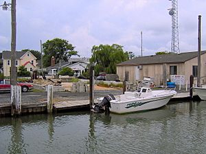
Harbor at Ewell
|
||
|
||
| Nickname(s):
"The Rock"
|
||
 |
||
| Country | ||
| State | ||
| County | ||
| Area | ||
| • Total | 9.18 sq mi (23.77 km2) | |
| • Land | 4.35 sq mi (11.27 km2) | |
| • Water | 4.83 sq mi (12.50 km2) | |
| Elevation | 0 ft (0 m) | |
| Population
(2020)
|
||
| • Total | 202 | |
| • Density | 46.44/sq mi (17.93/km2) | |
| Time zone | UTC−5 (Eastern (EST)) | |
| • Summer (DST) | UTC−4 (EDT) | |
| FIPS code | 24-72887 | |
| GNIS feature ID | 1852600 | |
Smith Island is a group of three small island towns – Tylerton, Rhodes Point, and Ewell, Maryland – located in the Chesapeake Bay. It sits on the border between Maryland and Virginia in the United States. This island is special because it's the last place in Maryland where people live that you can't reach by car. The part of the island in Virginia doesn't have anyone living on it right now.
Much of the island is slowly shrinking. This is happening because of ocean currents and rising sea levels. A study in 2008 by the DNR warned that Smith Island might disappear completely by the year 2100 if nothing is done.
About 220 people live on the island today. This number is much lower than its highest population of around 800 people. On the Maryland side, Smith Island is known as a census-designated place (CDP) in Somerset County. It is part of the larger Salisbury, Maryland-Delaware Metropolitan Statistical Area.
Contents
Exploring Smith Island's Location
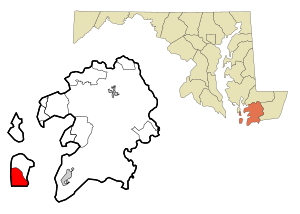
Smith Island is located about 10 miles (16 km) west of Crisfield, Maryland. It lies across the Tangier Sound, which is part of the Chesapeake Bay. The island has three main communities: Ewell, Tylerton, and Rhodes Point. All of these towns are on the Maryland side of the island. The Virginia part of the island is not inhabited, but it used to be home to many early settlers.
It's important to know that "Smith Island, Virginia" is a different island. It's a separate barrier island located off Cape Charles, even though it has the same name.
How Rising Sea Levels Affect Smith Island
By the 2010s, Smith Island had become smaller. This was mainly due to erosion and rising sea levels. Over the last 150 years, the island has lost more than 3,300 acres (13 km²) of its wetlands. Experts predict that the island could be completely gone by 2100 if sea levels rise by just one more foot.
To protect the island, people have started projects to prevent this. For example, a jetty (a wall built into the water) was finished in 2018. They are also moving waterways by dredging (clearing out mud and sand). These efforts to restore the island will continue for the next 50 years. The goal is to bring back 1,900 acres (7.7 km²) of submerged aquatic vegetation (plants that grow underwater) and 240 acres (0.97 km²) of wetlands. The island is also building more coastal defenses to protect itself.
Who Lives on Smith Island?
| Historical population | |||
|---|---|---|---|
| Census | Pop. | %± | |
| 2020 | 202 | — | |
| U.S. Decennial Census | |||
The Smith Island CDP is a small area in the middle of the island. It includes the three villages of Ewell, Rhodes Point, and Tylerton, all in Maryland. The northern part of Smith Island also has the Martin National Wildlife Refuge, which is a protected area for animals. The very southern part of the island, which is mostly marsh, is in Accomack County, Virginia.
In 2010, there were 276 people living in the Smith Island CDP. Most of the people living there were White (99.6%). A small number were African American (0.82%), Native American (0.27%), or from two or more races (0.82%). Many residents have English roots (51%), with smaller numbers having Greek, Irish, Scottish, and French backgrounds.
The average age of people on Smith Island was 50 years old. About 14.6% of the population was under 18, and 23.1% were 65 or older. The average household had 2.18 people.
Getting Around Smith Island
Smith Island does not have an airport or any bridges connecting it to the mainland. This means you can only get there by boat. There are ferries that carry only passengers. These ferries connect Smith Island (at Ewell) to Point Lookout, Maryland, and Reedville, Virginia. The ferry to Virginia runs only during certain seasons. The ferry from Crisfield, Maryland, runs all year round. There's also a daily passenger ferry between Crisfield, Maryland, and the smaller island of Tylerton, Maryland.
There are very few cars on the islands. Any cars that exist are in the northern town of Ewell and the connected Rhodes Point. For getting around, people in all three communities mostly use golf carts or walk.
Smith Island's Past and Unique Language
The explorer John Smith mapped the island a long time ago. British settlers arrived on the island in the 1600s. They came from places like Cornwall, Wales, and Dorset in England, often by way of Virginia. The island's population was largest in the early 1900s, with about 800 people.
Smith Island is home to one of the oldest English-speaking communities in the area. They have a special accent that sounds a lot like the way people spoke in England hundreds of years ago. This local way of speaking is similar to the dialects found in the West Country of England, including Cornwall. It also sounds a bit like the unique accent on nearby Tangier Island, Virginia.
In the past, there were some disagreements between the people of Smith Island, those on nearby Tangier Island, and the government. For example, there were conflicts over fishing areas and hunting rules. Islanders felt that nature's resources, like ducks, oysters, fish, and crabs, were given to them by God to use as they wished. They often disagreed with laws made by people about hunting and fishing.
The Island Belle was a ferry that used to carry passengers to the islands. It was added to the National Register of Historic Places in 1979 because of its historical importance.
After Hurricane Sandy hit in 2012, the Maryland Department of Housing and Community Development offered to buy land from people. However, most landowners on Smith Island chose not to sell their property.
The Famous Smith Island Cake
Smith Island has its own special foods, and the most famous is the Smith Island cake. This cake looks a bit like the German Prinzregententorte. It has eight to fifteen very thin layers of cake with cooked chocolate frosting in between.
Starting in the 1800s, people on Smith Island would send these cakes with the watermen when they went out for the autumn oyster harvest. Bakers started using fudge frosting instead of buttercream because fudge frosting made the cakes last much longer.
Traditional recipes for the cake often use evaporated milk. Recipes that start with a store-bought cake mix usually add condensed milk.
The most common Smith Island cake has yellow cake layers with chocolate frosting. But you can also find other flavors like coconut, fig, strawberry, lemon, and orange. Smith Island cake is baked for any special event; it's a dessert that doesn't need a holiday to be enjoyed.
Smith Island cake is also often the main prize in a local fundraising game called a cake walk. This game is played like musical chairs, and the donated cakes are the prizes. People pay close attention to making the cake layers perfectly thin. Before each round, the Smith Island cake that's up for grabs is cut in half and shown to the players. A cake with poorly stacked layers might not attract as many players, meaning it won't raise as much money.
Smith Island cake became the official state dessert of Maryland on April 24, 2008.
See also
 In Spanish: Smith Island (Maryland) para niños
 | DeHart Hubbard |
 | Wilma Rudolph |
 | Jesse Owens |
 | Jackie Joyner-Kersee |
 | Major Taylor |


