Splashdown facts for kids
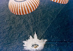
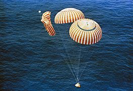
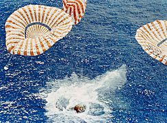
A splashdown is a special way for a spacecraft to land. Instead of landing on solid ground, it uses parachutes to gently drop into a large body of water, like an ocean.
This method was used by American space capsules carrying astronauts before the Space Shuttle program. Today, SpaceX Dragon and Dragon 2 capsules use splashdowns. NASA's Orion spacecraft also lands this way. Russian Soyuz spacecraft can land in water, but only if something goes wrong. The only time a Russian crewed spacecraft accidentally splashed down was with Soyuz 23.
Landing in water is helpful because the water acts like a giant cushion. This means the spacecraft doesn't need a special braking rocket to slow down right before landing. Spacecraft that land on land, like Russian and Chinese capsules, need these rockets. American space launches often happen from the coast, so landing in the ocean makes sense.
Contents
Missions That Used Splashdown
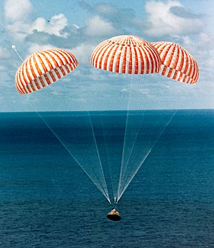
Many famous American space missions used splashdowns. These include the Mercury, Gemini, and Apollo missions. Even the Skylab space station missions used Apollo capsules for their crews to return to Earth.
One time, the Soyuz 23 spacecraft had an unexpected splashdown. It landed on a very cold lake with slushy ice during a snowstorm.
In the early Mercury flights, a helicopter would attach a cable to the capsule. It would then lift the capsule out of the water and take it to a nearby ship. This method changed after the Liberty Bell 7 capsule accidentally sank.
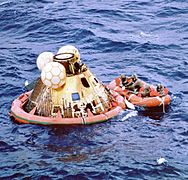
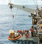
After that, all Mercury, Gemini, and Apollo capsules had a special floating collar. This collar was like a rubber life raft and helped the spacecraft float better. The spacecraft would then be brought next to a ship and lifted onto the deck using a crane.
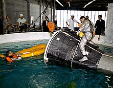
Once the floating collar was attached, a hatch on the spacecraft would open. Some astronauts chose to be lifted by helicopter to the recovery ship. Others decided to stay with the spacecraft and be lifted onto the ship by crane. Most Gemini and Apollo crews chose the helicopter ride. However, Mercury and Skylab crews often stayed with their spacecraft. This was especially true for Skylab, to protect important medical data. During the Gemini and Apollo programs, NASA used a special ship called MV Retriever for astronauts to practice getting out of the water.
When Apollo 11 returned from the Moon, it was the first time humans had walked on another planet. Scientists weren't sure if the astronauts might bring back "Moon germs." To be safe, the astronauts wore special suits called Biological Isolation Garments. Their suits were cleaned before they were lifted onto the USS Hornet ship. They then went into a special Mobile Quarantine Facility to make sure they were safe.
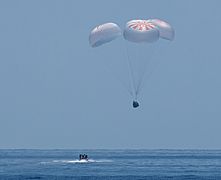
Both the SpaceX Dragon and Dragon 2 capsules were built to land using splashdowns. The first cargo Dragon capsules landed in the Pacific Ocean near Baja California. Now, both crew and cargo Dragon 2 capsules land off the coast of Florida. They land either in the Atlantic Ocean or the Gulf of Mexico.
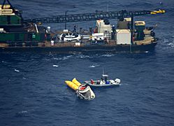
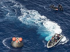
The new U.S. Orion spacecraft was first designed to land on land using parachutes and airbags. However, because of its weight, the airbag idea was dropped. Now, the Orion spacecraft is designed to splashdown in the Pacific Ocean, off the coast of California.
Challenges of Splashdown
One of the biggest dangers of a splashdown is the spacecraft flooding and sinking. For example, the hatch of Gus Grissom's Liberty Bell 7 capsule opened too early. The capsule sank, and Grissom almost drowned.
When a spacecraft hits the water, it's important to know where the most pressure will be. This helps engineers design the capsule to be strong enough. The way the air cushion around the capsule changes the water's surface before impact is also important.
If the capsule lands far from the recovery teams, the crew can be in more danger. For instance, Scott Carpenter in Aurora 7 landed about 400 kilometers (250 miles) away from his target. To avoid this, several recovery ships can be placed in different locations. However, this can be very expensive.
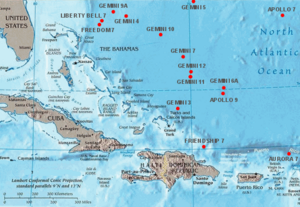
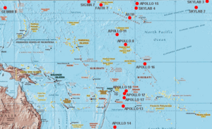
Splashdown Locations
Crewed Spacecraft Landings
| # | Spacecraft | Agency | Landing date | Coordinates |
|---|---|---|---|---|
| 1 | Freedom 7 | NASA | May 5, 1961 | 27°13.7′N 75°53′W / 27.2283°N 75.883°W |
| 2 | Liberty Bell 7 | NASA | July 21, 1961 | 27°32′N 75°44′W / 27.533°N 75.733°W |
| 3 | Friendship 7 | NASA | February 20, 1962 | 21°26′N 68°41′W / 21.433°N 68.683°W |
| 4 | Aurora 7 | NASA | May 24, 1962 | 19°27′N 63°59′W / 19.450°N 63.983°W |
| 5 | Sigma 7 | NASA | October 3, 1962 | 32°06′N 174°28′W / 32.100°N 174.467°W |
| 6 | Faith 7 | NASA | May 16, 1963 | 27°20′N 176°26′W / 27.333°N 176.433°W |
| 7 | Gemini 3 | NASA | March 23, 1965 | 22°26′N 70°51′W / 22.433°N 70.850°W |
| 8 | Gemini 4 | NASA | June 7, 1965 | 27°44′N 74°11′W / 27.733°N 74.183°W |
| 9 | Gemini 5 | NASA | August 29, 1965 | 29°44′N 69°45′W / 29.733°N 69.750°W |
| 10 | Gemini 7 | NASA | December 18, 1965 | 25°25′N 70°07′W / 25.417°N 70.117°W |
| 11 | Gemini 6A | NASA | December 16, 1965 | 23°35′N 67°50′W / 23.583°N 67.833°W |
| 12 | Gemini 8 | NASA | March 17, 1966 | 25°14′N 136°0′E / 25.233°N 136.000°E |
| 13 | Gemini 9A | NASA | June 6, 1966 | 27°52′N 75°0′W / 27.867°N 75.000°W |
| 14 | Gemini 10 | NASA | July 21, 1966 | 26°45′N 71°57′W / 26.750°N 71.950°W |
| 15 | Gemini 11 | NASA | September 15, 1966 | 24°15′N 70°0′W / 24.250°N 70.000°W |
| 16 | Gemini 12 | NASA | November 15, 1966 | 24°35′N 69°57′W / 24.583°N 69.950°W |
| 17 | Apollo 7 | NASA | October 22, 1968 | 27°32′N 64°04′W / 27.533°N 64.067°W |
| 18 | Apollo 8 | NASA | December 27, 1968 | 8°7.5′N 165°1.2′W / 8.1250°N 165.0200°W |
| 19 | Apollo 9 | NASA | March 13, 1969 | 23°15′N 67°56′W / 23.250°N 67.933°W |
| 20 | Apollo 10 | NASA | May 26, 1969 | 15°2′S 164°39′W / 15.033°S 164.650°W |
| 21 | Apollo 11 | NASA | July 24, 1969 | 13°19′N 169°9′W / 13.317°N 169.150°W |
| 22 | Apollo 12 | NASA | November 24, 1969 | 15°47′S 165°9′W / 15.783°S 165.150°W |
| 23 | Apollo 13 | NASA | April 17, 1970 | 21°38′S 165°22′W / 21.633°S 165.367°W |
| 24 | Apollo 14 | NASA | February 9, 1971 | 27°1′S 172°39′W / 27.017°S 172.650°W |
| 25 | Apollo 15 | NASA | August 7, 1971 | 26°7′N 158°8′W / 26.117°N 158.133°W |
| 26 | Apollo 16 | NASA | April 27, 1972 | 0°43′S 156°13′W / 0.717°S 156.217°W |
| 27 | Apollo 17 | NASA | December 19, 1972 | 17°53′S 166°7′W / 17.883°S 166.117°W |
| 28 | Skylab 2 | NASA | June 22, 1973 | 24°45′N 127°2′W / 24.750°N 127.033°W |
| 29 | Skylab 3 | NASA | September 25, 1973 | 30°47′N 120°29′W / 30.783°N 120.483°W |
| 30 | Skylab 4 | NASA | February 8, 1974 | 31°18′N 119°48′W / 31.300°N 119.800°W |
| 31 | Apollo CSM-111 | NASA | July 24, 1975 | 22°N 163°W / 22°N 163°W |
| 32 | Soyuz 23 | USSR | October 16, 1976 | Lake Tengiz |
| 33 | Crew Dragon Demo-2 | SpaceX | August 2, 2020 | 29°48′N 87°30′W / 29.800°N 87.500°W |
| 33 | Crew Dragon Crew-1 | SpaceX | May 2, 2021 | 29°32′N 86°11′W / 29.533°N 86.183°W |
| 34 | Inspiration4 | SpaceX | September 18, 2021 | |
| 35 | Crew Dragon Crew-2 | SpaceX | November 7, 2021 | |
| 35 | Axiom Mission 1 | SpaceX | April 25, 2022 | |
| 36 | Crew Dragon Crew-3 | SpaceX | May 6, 2022 | |
| 37 | Crew Dragon Crew-4 | SpaceX | October 14, 2022 | |
| 38 | Crew Dragon Crew-5 | SpaceX | March 11, 2023 |
Uncrewed Spacecraft Landings
| Spacecraft | Agency | Landing date | Coordinates |
|---|---|---|---|
| Jupiter AM-18 (Able and Baker) |
USAF | May 28, 1959 | 48 to 96 km (30 to 60 mi) N Antigua Island |
| Mercury-Big Joe | NASA | September 9, 1959 | 2,407 km (1,496 mi) SE Cape Canaveral |
| Mercury-Little Joe 2 Sam The Rhesus Monkey |
NASA | December 4, 1959 | 319 km (198 mi) SE Wallops Island, Virginia |
| Mercury-Redstone 1A | NASA | December 19, 1960 | 378.2 km (235.0 mi) SE Cape Canaveral |
| Mercury-Redstone 2 | NASA | January 31, 1961 | 675.9 km (420.0 mi) SE Cape Canaveral |
| Mercury-Atlas 2 | NASA | February 21, 1961 | 2,293.3 km (1,425.0 mi) SE Cape Canaveral |
| Discoverer 25 (Corona 9017) |
USAF | June 16, 1961 | |
| Mercury-Atlas 4 | NASA | September 13, 1961 | 257.5 km (160.0 mi) E of Bermuda |
| Mercury-Atlas 5 | NASA | November 29, 1961 | 804.7 km (500.0 mi) SE of Bermuda |
| Gemini 2 | NASA | January 19, 1965 | 16°33.9′N 49°46.27′W / 16.5650°N 49.77117°W 3,423.1 km (2,127.0 mi) downrange from KSC |
| AS-201 | NASA | February 26, 1966 | 8°11′S 11°09′W / 8.18°S 11.15°W 8,472 km (5,264 mi) downrange from KSC |
| AS-202 | NASA | August 25, 1966 | 16°07′N 168°54′E / 16.12°N 168.9°E 804.7 km (500.0 mi) southwest of Wake Island |
| Gemini 2-MOL | USAF | November 3, 1966 | 8,149.7 km (5,064.0 mi) SE KSC near Ascension Island |
| Apollo 4 | NASA | November 9, 1967 | 30°06′N 172°32′W / 30.1°N 172.53°W |
| Apollo 6 | NASA | April 4, 1968 | 27°40′N 157°59′W / 27.667°N 157.983°W |
| Zond 5 | USSR | September 21, 1968 | 32°38′S 65°33′E / 32.63°S 65.55°E |
| Zond 8 | USSR | October 27, 1970 | 730 km (450 mi) SE of the Chagos Archipelago, Indian Ocean |
| Cosmos 1374 | USSR | June 4, 1982 | 17°S 98°E / 17°S 98°E 560 km (350 mi) S of Cocos Islands, Indian Ocean |
| Cosmos 1445 | USSR | March 15, 1983 | 556 km (345 mi) S of Cocos Islands, Indian Ocean |
| Cosmos 1517 | USSR | December 27, 1983 | near Crimea, Black Sea |
| Cosmos 1614 | USSR | December 19, 1984 | ? km W of the Crimea, Black Sea |
| COTS Demo Flight 1 | SpaceX | December 8, 2010 | 800 km (500 mi) west of Baja California, Mexico, Pacific Ocean |
| Dragon C2+ | SpaceX | May 31, 2012 | 26°55′N 120°42′W / 26.92°N 120.7°W |
| CRS SpX-1 | SpaceX | October 28, 2012 | ? |
| CRS SpX-2 | SpaceX | March 27, 2013 | ? |
| Exploration Flight Test 1 | NASA | December 5, 2014 | 23°36′N 116°24′W / 23.6°N 116.4°W, 443 kilometres (275 mi) west of Baja California |
| Crew Dragon Demo-1 | SpaceX | March 8, 2019 | In the Gulf of Mexico, off the coast of Pensacola, Florida |
| SpaceX CRS-21 | SpaceX | January 14, 2020 | In the Gulf of Mexico, off the coast of Tampa, Florida |
| Artemis I | NASA | December 11, 2022 | Pacific Ocean, west of Baja California |
Gallery
-
The Apollo 15 spacecraft splashed down safely despite a parachute failure. (NASA)
-
Apollo 15 splashdown (NASA)
-
Apollo 11 after splashdown (NASA)
-
Apollo 13 hoisted onto ship (NASA)
-
Gemini water egress training
-
Landing of SpaceX Demo-2, 2 August 2020
See also
 In Spanish: Amerizaje para niños
- Apollo program
- Apollo–Soyuz Test Project
- Helicopter 66
- Project Gemini
- Project Mercury
- Skylab
- SpaceX Dragon
- SpaceX Dragon 2
- Water landing
- Zond program
 | Emma Amos |
 | Edward Mitchell Bannister |
 | Larry D. Alexander |
 | Ernie Barnes |


