St Albans, New South Wales facts for kids
Quick facts for kids St AlbansNew South Wales |
|||||||||||||||
|---|---|---|---|---|---|---|---|---|---|---|---|---|---|---|---|

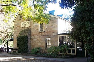
Settlers Arms Inn
|
|||||||||||||||
| Population |
|
||||||||||||||
| Postcode(s) | 2775 | ||||||||||||||
| Elevation | 13 m (43 ft) | ||||||||||||||
| Location | 94 km (58 mi) NW of Sydney CBD | ||||||||||||||
| LGA(s) | City of Hawkesbury | ||||||||||||||
| State electorate(s) | Hawkesbury | ||||||||||||||
| Federal Division(s) | Macquarie | ||||||||||||||
|
|||||||||||||||
St Albans is a small and historic village in New South Wales, Australia. It is located on the Macdonald River, about 94 kilometers (65 miles) northwest of Sydney. In 2011, St Albans and the areas around it had a population of 305 people.
Contents
History of St Albans
The first people to live in the Hawkesbury area were the Darug tribe of Aboriginal people. They also spelled their name Dharug or Daruk. The river, which they called Derrubbin, was very important to them. It provided food and was used for travel. The Darug people fished for fish, eels, and water birds. They also used bark canoes to travel on the river.
Europeans first settled here in 1794. They needed more land to grow food for the growing penal colony in Sydney. In April 1794, Lieutenant Governor Francis Grose planned the first 22 farms. These were on the Hawkesbury River in the area now called Pitt Town Bottoms.
The "Village of Macdonald" was mapped out in 1837. It was later renamed St Albans on January 26, 1841. The new name came from the city of St Albans in Hertfordshire, England.
In the early days of the colony, the Macdonald Valley was an important farming area. This was because it was easy to reach by water. However, when railways were built and more farms started west of the Great Dividing Range, the Macdonald Valley became less important. It turned into a quiet, remote place. Locals often call the valley the "Forgotten Valley."
St Albans is on the Macdonald River, which flows into the Hawkesbury River. The Hawkesbury River is about 15 kilometers (9.5 miles) south. The village was opened for settlement in 1842. It became a key stopping point for farmers. They would ship their goods down the Hawkesbury River to Sydney from here. St Albans was as far up the Macdonald River as boats could go. Today, sand and silt have made this part of the river much harder to navigate.
Getting to St Albans
Two free, 24-hour car ferries help people get to St Albans from the Sydney area. The roads follow old paths used by goats and horses on both sides of the Macdonald River. These roads wind through beautiful countryside and farms. You can see cattle, melons, orchards, and corn. On both sides of the river are old homes and amazing tall sandstone hills.
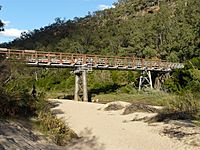
One way to get there is through the Wisemans Ferry township. You cross the Hawkesbury River using the Wisemans ferry. Then, you follow the road on the eastern side of the Macdonald River. The first bridge over the river connects the two roads at St Albans.
Another way is to turn left just before entering Wisemans Ferry township. You cross the Hawkesbury River using the Webbs Creek Ferry. Then, you follow the road up the western side of the Macdonald River to the village.
Old Churches and Burial Ground
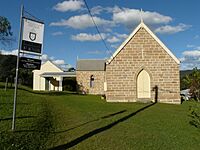
The St Albans Anglican Church (Saint Alban The Martyr) is near the top of Wharf Road. It is the only church still used today. A wooden chapel opened in 1843. The stone building you see now replaced it in 1897.
Another interesting stone church in the village is the old Wesleyan Methodist church. It is on Espie Street. This church was built in 1902. It is now owned by private people. It reminds us of almost 150 years of Wesleyan influence in the Macdonald Valley.
Funerals for people close to town often went by boat to the old St Albans Burial Ground. This cemetery is a few kilometers south of the village, next to the river. It was started in 1826. In the past, this site suffered from neglect, floods, and vandalism. But now, it is being protected.
Historic Buildings to Explore
Two places in St Albans are listed on the New South Wales Heritage Register. This means they are very important historical sites:
- 181 Main Road: MacDonald River bridge
- 37 Upper Macdonald Road: Price Morris Cottage
Other important historic places include:
- The Court House and Police lockup: This building was built in 1890. It sits high above the Macdonald River and St Albans. The building originally had a courtroom, a police station, and a lock-up (jail). Today, it offers comfortable places to stay overnight or for holidays. The original yard where prisoners exercised is now a fun area. The two original jail cells are now unique bathrooms. The building is recognized by the National Trust and has a special heritage listing from the City of Hawkesbury.
- The Settlers Arms Inn: This inn was first called Travellers Rest. It is in a beautiful spot facing the river and is very well preserved. In July 1842, the first land sales happened in St Albans. John Sullivan bought seven plots of land. He built the Settlers Arms Inn on them. It was built at a place where cattle drovers camped. This was also the furthest point boats could travel on the Macdonald River. It still operates today, offering "conversation, beer, and accommodation." There is some confusion about when it was built. Its license was issued in 1836, but a newspaper report from 1848 suggests it was still being built then.
- Price Morris Cottage: This cottage was built in 1837. It took 8 years to build and 2 years to restore. It has walls made of vertical timber slabs and a mix of mud and straw (wattle and daub). The ceilings were made of calico, and the roof was shingled. Price Morris, a former convict who became a farmer, received this 50-acre (20-hectare) property in 1837. In the 1830s, Welsh Methodists settled in the area. The Price Morris cottage became a central place for Methodist meetings and worship. A Methodist church was later built in St. Albans, but the cottage continued to be used for meetings until the late 1960s. One of the preachers there was the grandfather of Sir Alan Walker, who started the Central Methodist Mission.
When the River Rises
St Albans has experienced very big floods. Some of the worst were in 1867, 1889, 1913, and especially 1949. The town is about fifty feet above the riverbed. The bridge floor is forty feet above the sand.
In the 1889 flood, the bridge was completely covered by water. The Court House was not washed away, but the Police quarters were. The water rose so high it reached the eaves (the lower edges of the roof) of Jurds Hotel (which is now the Settlers Arms Inn). It left a hole seven feet deep in front of the hotel. The old stone house was partly washed away. The floodwaters reached the veranda eaves and washed away five houses. Another new house on the other side of the river was also swept away.
 | Delilah Pierce |
 | Gordon Parks |
 | Augusta Savage |
 | Charles Ethan Porter |


