Stapleford Tawney facts for kids
Quick facts for kids Stapleford Tawney |
|
|---|---|
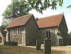
 St Mary's Church, Stapleford Tawney |
|
| Population | 103 |
| Civil parish |
|
| District | |
| Shire county | |
| Region | |
| Country | England |
| Sovereign state | United Kingdom |
| Post town | EPPING |
| Postcode district | CM16 |
| Post town | ROMFORD |
| Postcode district | RM4 |
| Dialling code | 01992 |
| Police | Essex |
| Fire | Essex |
| Ambulance | East of England |
| EU Parliament | East of England |
| UK Parliament |
|
Stapleford Tawney is a small village and a civil parish in the Epping Forest area of Essex, England. A civil parish is like a local community area with its own council. This village is about 4 kilometers (2.5 miles) west-southwest of Chipping Ongar. It is also about 14 kilometers (8.7 miles) southwest of Chelmsford, which is the main town of the county.
A Look Back in Time
Stapleford Tawney has a long history. In the past, it was part of a larger area called the hundred of Ongar. A "hundred" was an old way of dividing land in England.
Later, from 1894, the village was part of the Ongar Rural District Council. This was a local government group that looked after the countryside. In 1955, it joined with another area to form the Epping and Ongar Rural District Council. Then, in 1974, after some big changes to local government, Stapleford Tawney became part of the Epping Forest District.
Modern services came to the village over time. Electricity was first connected to the area in 1932. Most homes also started getting water from the Herts and Essex Waterworks Co. in 1949.
How Many People Live Here?
The number of people living in Stapleford Tawney has changed a lot. More people lived here in the past, especially during the Victorian period.
| Year | Population |
|---|---|
| 1801 | 196 |
| 1841 | 350 |
| 1951 | 153 |
| 2001 | 103 |
In 2001, the village had 103 people. This made it the least populated parish in its district. The population density was about 15.4 people per square kilometer. This means there weren't many people living close together.
Where is Stapleford Tawney?
The area of Stapleford Tawney is long and narrow. It stretches about 3 kilometers (1.9 miles) from north to south. But it is usually only about 1 kilometer (0.6 miles) wide.
The River Roding forms the southern edge of the parish. A small stream that flows into the river makes up much of its western border. The land here rises quite steeply. It goes from below 30 meters (98 feet) near the River Roding to over 90 meters (295 feet) in the far north. Most of the parish is above 60 meters (197 feet) high. The total area of the parish is 670 hectares.
There isn't one main center where everyone lives in the village. The parish Church of St Mary is on Tawney Lane. It is part of a small group of houses and farms. In the north of the parish, about 2 kilometers (1.2 miles) from the church, are two small groups of homes called Colliers Hatch and Tawney Common.
Many individual farms and houses are spread out across the parish. Most of the land is used for farming. The M25 motorway, a very busy road, cuts through the very southern part of the parish.
 | Dorothy Vaughan |
 | Charles Henry Turner |
 | Hildrus Poindexter |
 | Henry Cecil McBay |


