
Epping Forest District facts for kids
Quick facts for kids
Epping Forest
Epping Forest District
|
|
|---|---|
|
Non-metropolitan district
|
|

Ongar, one of the towns of the district
|
|

Epping Forest shown within Essex
|
|
| Sovereign state | United Kingdom |
| Constituent country | England |
| Region | East of England |
| Non-metropolitan county | Essex |
| Status | Non-metropolitan district |
| Admin HQ | Epping |
| Incorporated | 1 April 1974 |
| Government | |
| • Type | Non-metropolitan district council |
| • Body | Epping Forest District Council |
| Area | |
| • Total | 130.88 sq mi (338.99 km2) |
| Area rank | 125th (of 326) |
| Population
(2005 est.)
|
|
| • Total | 131,689 |
| • Rank | 170th (of 326) |
| • Density | 1,006.145/sq mi (388.475/km2) |
| • Ethnicity | 95.4% White 2.7% S.Asian 1.3% Black 0.6% Mixed Race |
| Time zone | UTC0 (GMT) |
| • Summer (DST) | UTC+1 (BST) |
| ONS code | 22UH (ONS) E07000072 (GSS) |
| OS grid reference | TL455025 |
The Epping Forest District is a special area in Essex, England. It's named after the famous ancient woodland called Epping Forest, which covers a big part of the district. The main office for the local government is in the town of Epping.
This district also includes other towns like Loughton, Ongar, and Waltham Abbey. There are also many villages and countryside areas. Epping Forest District is located in the western part of Essex, right next to the north-eastern edge of London. It shares borders with several other districts and London boroughs.
Contents
History of Epping Forest District
The Epping Forest District was created on April 1, 1974. This happened because of a law called the Local Government Act 1972. Before this, the area was made up of several smaller districts that were then combined.
These older districts included:
- Chigwell Urban District (which had Loughton and Buckhurst Hill)
- Most of the Epping and Ongar Rural District
- Epping Urban District
- Waltham Holy Cross Urban District
The new district was given the name Epping Forest because of the ancient woodland. This forest is also named after the town of Epping.
Since 1974, there have been a few small changes to the district's border with Greater London. For example, in 1994, an area that is now Enfield Island Village became part of the London Borough of Enfield. In 1995, a small area near Grange Hill and Roding Valley stations moved to the London Borough of Redbridge.
How Epping Forest District is Governed
| Epping Forest District Council | |
|---|---|
| Type | |
| Type |
Non-metropolitan district
|
| Leadership | |
|
Leader
|
|
|
Georgina Blakemore
Since 1 April 2019 |
|
| Structure | |
| Seats | 58 |
|
Political groups
|
Opposition (24)
|
| Elections | |
|
Last election
|
4 May 2023 |
|
Next election
|
2024 |
| Meeting place | |
 |
|
| Civic Offices, 323 High Street, Epping, CM16 4BZ | |
The Epping Forest District Council is in charge of local services. These include things like collecting trash, managing local parks, and planning new buildings. Services for the wider county, like schools and major roads, are handled by Essex County Council.
The district is also divided into smaller areas called civil parishes. These have their own local councils that deal with very local issues.
Political Control of the Council
The Conservative Party has been in control of the council since 2006. This means they have the most councillors and lead the decisions made.
The first election for the council was in 1973. Here's how political control has changed over the years:
| Party in control | Years | |
|---|---|---|
| Conservative | 1974–1994 | |
| No overall control | 1994–2006 | |
| Conservative | 2006–present | |
Leaders of the Council
The leader of the council is like the head of the local government. Here are the leaders since 2001:
| Councillor | Party | From | To | |
|---|---|---|---|---|
| Andrew Thompson | Liberal Democrats | 15 May 2001 | 5 May 2002 | |
| Maggie McEwen | Conservative | 14 May 2002 | 18 Feb 2003 | |
| Michael Heavens | Liberal Democrats | 24 Feb 2003 | 24 Jun 2004 | |
| John Knapman | Chigwell Residents' Association | 24 Jun 2004 | 18 May 2006 | |
| Diana Collins | Conservative | 18 May 2006 | 18 May 2011 | |
| Lesley Wagland | Conservative | 18 May 2011 | 22 May 2012 | |
| Chris Whitbread | Conservative | 22 May 2012 | ||
Council Members and Parties
After the election in 2023, the council is made up of 58 councillors from different political groups:
| Party | Councillors | |
|---|---|---|
| Conservative | 34 | |
| Loughton Residents Association | 13 | |
| Liberal Democrats | 6 | |
| Independent | 3 | |
| Green | 2 | |
| Total | 58 | |
The next election for the council is planned for 2024.
Council Buildings
The main office for the Epping Forest District Council is called the Civic Offices. It's located at 323 High Street in Epping.
When the council first started, it used four different buildings. These were in Loughton, Epping, and Waltham Abbey. Later, a large new building was added next to the original office in Epping. This new Civic Offices building was finished in 1992. It is now considered a special historic building.
Geography of Epping Forest District
The north-east part of the district is mostly countryside. It has small villages like Chipping Ongar. This area is not very crowded, even though it's close to London. The south-west part of the district is more like a suburb. This is where Loughton, the biggest town, is located.
The district has many different types of buildings and landscapes. Loughton is next to the Epping Forest woodland. Other areas have farms, rivers, and golf courses. The River Roding flows through the eastern part of the district. The Lea Valley is in the west.
Even though towns like Buckhurst Hill, Chigwell, and Waltham Abbey are not in Greater London, they are considered part of the "Greater London Built-up Area" by the government.
Epping Forest District is surrounded by other districts. These include Harlow, Uttlesford, Chelmsford, and Brentwood in Essex. It also borders East Hertfordshire and Broxbourne in Hertfordshire. To the south, it touches the London boroughs of Havering, Redbridge, Waltham Forest, and Enfield.
Transport in Epping Forest District
You can get around Epping Forest District in many ways, including by train, car, bike, and even boat!
Train Travel
The only National Rail station directly in the district is Roydon railway station. It's on the border with East Hertfordshire. Other nearby stations like Sawbridgeworth railway station and Waltham Cross railway station also serve the district. These stations connect to places like London Liverpool Street and Cambridge.
The London Underground Central line runs through the southern part of Epping Forest. Stations like Epping, Theydon Bois, Debden, and Loughton are in the district. This line connects the district directly to East London, The City, and the West End.
There's also a special old part of the Central line. It used to run between Epping and Chipping Ongar. Now, it's a heritage railway called the Epping Ongar Railway.
Road Travel
Two major motorways meet in the district: the M25 and the M11 motorway.
- The M25 goes around London. It connects to places like Brentwood and Heathrow Airport.
- The M11 goes north towards Stansted Airport and Cambridge. It goes south towards East London.
Other important roads in the district include the A414 (connecting Harlow and Chelmsford) and the A104 Epping New Road. Most local roads are managed by Essex County Council. The M11 and M25 motorways are managed by National Highways.
Cycling Paths
National Cycle Network Route 1 passes through the district. It connects to other cycle routes in Hertfordshire and London. There are also paths along the River Lee and River Stort. The City of London Corporation manages many shared paths in Epping Forest itself.
Air Travel
North Weald Airfield is located in the district and is open for small planes. Flying started here during the First World War in 1916. Stapleford Aerodrome is also in the district and has a flight training center. For bigger flights, Stansted Airport is nearby in the next district.
Rivers for Boats
The Lee Navigation and River Stort are rivers where boats can travel. They form the eastern border of the district. These rivers are managed by the Canal and River Trust. They connect to London's canals, like the Regent's Canal.
Nature Reserves and Wildlife Areas

Epping Forest District has many beautiful places where nature is protected. The Epping Forest District Council looks after nine local nature reserves (LNRs):
- Chigwell Row Wood LNR
- Church Lane Flood Meadow LNR
- Home Mead LNR
- Linder's Field LNR
- Nazeing Triangle LNR
- Roding Valley Meadows LNR
- Roughtalley's Wood LNR
- Thornwood Flood Meadow LNR
- Weald Common Flood Meadows LNR
Roding Valley Meadows is the oldest and largest local nature reserve in the district. It was created in 1986 and covers 56 hectares.
There are also seven Sites of Special Scientific Interest (SSSIs) in the district. These are areas that are especially important for their wildlife or geology. They include parts of Epping Forest and Roding Valley Meadows.
The Essex Wildlife Trust also manages some nature sites in the area. These include Gernon Bushes Nature Reserve and parts of Hunsdon Mead.
A large part of Epping Forest itself is within the district. The City of London Corporation has owned and protected this forest since 1878.
Elections and Wards
Local Elections
The Epping Forest District Council has 58 councillors. These councillors represent 32 different areas called wards. Each ward elects one, two, or three councillors.
Elections for the council happen three out of every four years. About a third of the councillors are elected each time for a four-year period. In the fourth year, there are no district council elections. Instead, there are elections for the Essex County Council.
The wards in the district are:
- Broadley Common, Epping Upland and Nazeing
- Buckhurst Hill East
- Buckhurst Hill West
- Chigwell Row
- Chigwell Village
- Chipping Ongar, Greensted and Marden Ash
- Epping Hemnall
- Epping Lindsey and Thornwood Common
- Grange Hill
- Hastingwood, Matching and Sheering Village
- High Ongar, Willingale and the Rodings
- Lambourne
- Loughton Alderton
- Loughton Broadway
- Loughton Fairmead
- Loughton Forest
- Loughton Roding
- Loughton St John's
- Loughton St Mary's
- Lower Nazeing
- Lower Sheering
- Moreton and Fyfield
- North Weald Bassett
- Passingford
- Roydon
- Shelley
- Theydon Bois
- Waltham Abbey High Beach
- Waltham Abbey Honey Lane
- Waltham Abbey North East
- Waltham Abbey Paternoster
- Waltham Abbey South West
New ward boundaries are being planned and will be used for the 2024 elections.
County Council Elections
In the most recent county council elections in 2021, seven councillors were elected from the Epping Forest area. Six of them were from the Conservative Party, and one was from the Loughton Residents Association.
Parliamentary Constituencies
The district is part of three different areas for the UK Parliament. These are called constituencies. Each constituency elects one Member of Parliament (MP) to represent them in the national government.
- Epping Forest constituency covers most of the western part of the district. This includes towns like Buckhurst Hill, Loughton, and Epping.
- Brentwood and Ongar constituency mostly covers the eastern part of the district. This includes the town of Ongar.
- Harlow constituency includes villages like Roydon and Lower Nazeing.
Parishes of Epping Forest District

The Epping Forest District is divided into 28 smaller areas called civil parishes. Many of these parishes have their own local councils, called parish councils. The parish councils for Epping, Loughton, Ongar, and Waltham Abbey are called "town councils." Some smaller parishes share a council, like Moreton, Bobbingworth, and the Lavers Parish Council.
- Abbess Beauchamp and Berners Roding
- Bobbingworth
- Buckhurst Hill
- Chigwell
- Epping (town)
- Epping Upland
- Fyfield
- High Laver
- High Ongar
- Lambourne
- Little Laver
- Loughton (town)
- Magdalen Laver
- Matching
- Moreton
- Nazeing
- North Weald Bassett
- Ongar (town)
- Roydon
- Sheering
- Stanford Rivers
- Stapleford Abbotts
- Stapleford Tawney
- Theydon Bois
- Theydon Garnon
- Theydon Mount
- Waltham Abbey (town)
- Willingale
Images for kids
-
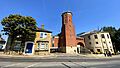
The Civic Offices in Epping, where the council meets.
See also
 In Spanish: Distrito de Epping Forest para niños
