Epping Upland facts for kids
Quick facts for kids Epping Upland |
|
|---|---|
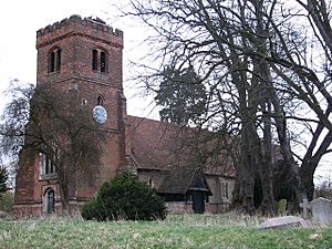
 All Saints' Church, Epping Upland |
|
| Population | 831 (2011 Census) |
| OS grid reference | TL444045 |
| • London | 15 mi (24 km) SSW |
| District | |
| Shire county | |
| Region | |
| Country | England |
| Sovereign state | United Kingdom |
| Post town | EPPING |
| Postcode district | CM16 |
| Dialling code | 01992 |
| Police | Essex |
| Fire | Essex |
| Ambulance | East of England |
| EU Parliament | East of England |
| UK Parliament |
|
Epping Upland is a small village in Essex, England. It is located in the Epping Forest area. This village was once known simply as Epping.
You can find Epping Upland on the B181 road. It is about 3 kilometres (2 miles) south of Harlow. It is also about 3 kilometres (2 miles) north-west of the town of Epping. The M11 motorway is also nearby.
Contents
All Saints' Church: A Historic Building
Epping Upland has a very old church called All Saints' Church. It is a parish church. The church is part of the Diocese of Chelmsford.
Church History and Design
This church was built way back in the 13th century. That makes it over 700 years old! It is so important that it is a Grade II* listed building. This means it has special historical value.
For a long time, until the Dissolution of the Monasteries (when many monasteries were closed in the 1500s), All Saints' Church was managed by Waltham Abbey.
In the early 1800s, part of what is now the town of Epping was actually part of Epping Upland. The church served this larger area. Later, the busy market part of Epping Upland joined with a small settlement called Epping Street. Together, they became the town of Epping we know today.
Life in Epping Upland in the Past
In 1831, Epping Upland village had 427 people living in 83 houses. Most people in the village, about 80%, worked in farming. Across the whole parish, about 40% of people worked in agriculture.
Historic Homes and Wartime Events
Besides the church, Epping Upland has other old buildings. One of them is Takeleys.
Takeleys: A Timber-Framed House
Takeleys is a Grade II listed house. It is a timber-framed house, which means its walls are made from a wooden frame. It was built around the 16th century. It even has a moat around it! Inside, you can find a beautifully carved fireplace. One of the upstairs rooms has 17th-century wall paintings. These paintings show flowers in brown and black colours on plaster.
World War II History
Epping Upland also has a connection to World War II. On September 8, 1944, the first German V-2 rocket to be launched landed here. This was a significant event during the war.
Community and Transport
Epping Upland is home to Epping Upland C of E Primary School. This is the local school for children in the area.
The village has bus services. These buses connect Epping Upland to the towns of Epping and Harlow.
Epping Upland Civil Parish
The Epping Upland civil parish is a larger area than just the village. It stretches quite a distance.
Parish Boundaries and Settlements
The parish goes from the southern edge of Harlow in the north. It reaches all the way to the M25 motorway in the south. This is a distance of about 8 kilometres (5 miles). It also extends about 5 kilometres (3 miles) west of Thornwood Common in the east.
Inside this parish, you will find the village of Epping Green. There are also smaller settlements called Jacks Hatch and Rye Hill. These are located near the northern edge of the parish.
Population Changes
In 2001, the population of Epping Upland Parish was 790 people. By the 2011 Census, the population had grown slightly to 831 people.
Ancient Earthworks
The parish also contains ancient earthwork remains. These are called Ambresbury Banks. It is an Iron Age hill fort. This means it was a fortified settlement from the Iron Age, a very long time ago. It is a scheduled monument, which gives it special protection.
 | James Van Der Zee |
 | Alma Thomas |
 | Ellis Wilson |
 | Margaret Taylor-Burroughs |


