
Stapleford Abbotts facts for kids
Quick facts for kids Stapleford Abbotts |
|
|---|---|
 Church of St Mary Grade II architecturally listed |
|
 Tysea Hill, Stapleford Abbots |
|

Stapleford Abbotts
|
|
| Area | 9.57 km2 (3.69 sq mi) |
| Population | 959 (2001) 1,008 (2001) |
| • Density | 100/km2 (260/sq mi) |
| OS grid reference | TQ505955 |
| • London | 16.2 mi (26.1 km) SW |
| Civil parish |
|
| District | |
| Shire county | |
| Region | |
| Country | England |
| Sovereign state | United Kingdom |
| Post town | ROMFORD |
| Postcode district | RM4 |
| Dialling code | 01708 |
| Police | Essex |
| Fire | Essex |
| Ambulance | East of England |
| EU Parliament | East of England |
| UK Parliament |
|
Stapleford Abbotts is a small village and civil parish in the Epping Forest area of Essex, England. It is about 9 kilometers (5.6 miles) southwest of Ongar. The village is also about 7 kilometers (4.3 miles) north of Romford and 8 kilometers (5 miles) southeast of Epping. The entire parish is located within the M25 motorway area. In 2011, the village had a population of 1,008 people.
Contents
Exploring Stapleford Abbotts' Past
The name Stapleford Abbotts comes from its history. A long time ago, the main estate here was owned by the Abbey of Bury St Edmunds. They owned it even before the Norman Conquest in 1066. They kept it until the Dissolution in the 1500s.
How the Abbey Gained the Manor
There's a story that the lord of the manor was very sick in 1013. He got better after the body of St Edmund passed through on its way back to Bury Abbey from London. Because he was cured, he gave the manor to the abbey.
Changes in Ownership and Population
After the monasteries were closed down, the manor changed hands many times. It was even owned by King Henry VIII for a short period.
The number of people living in Stapleford Abbotts has changed over time.
- In 1801, there were 320 people.
- By 1831, the population grew to 507.
- It stayed around that number until 1921, when it was 391.
- From the 1930s onwards, more houses were built. This caused the population to increase.
- In 1951, 731 people lived in the village.
Local Government History
Historically, Stapleford Abbotts was part of a larger area called the hundred of Ongar. Later, it became part of different local councils. Since 1974, it has been part of the Epping Forest District. The boundaries of the parish today are mostly the same as they were in the mid-1800s.
Understanding Stapleford Abbotts' Geography
The parish of Stapleford Abbotts is mostly countryside. You'll find many farms and small houses scattered around. A lot of this land is protected as Metropolitan Green Belt. This means it's kept natural and open.
Rivers and Hills
The northern edge of the parish is along the River Roding. Other small streams flow through the area, either joining the Roding or forming the start of the River Rom. The land is quite hilly, ranging from 28 to 90 meters (92 to 295 feet) above sea level.
The Village Layout
The main village of Stapleford Abbotts stretches for about a mile. It's mostly made up of houses built in the 20th century. These houses are along the road that goes from Romford to Ongar.
The old church, which was mostly rebuilt in the 1800s, is about a mile away from the main village. This shows that the village didn't have one central spot until more recently.
Nearby Hamlets and Places
Besides the main village, the parish also includes smaller areas called hamlets. These include Bournebridge, Nuper's Hatch, and a small part of Passingford Bridge. You might also hear of Stapleford Flight Centre, which offers sightseeing flights, and Stapleford Abbotts Golf Course.
Bournebridge Hamlet
Bournebridge is a small hamlet next to a farm on the main street. The Bourne Bridge itself crosses the Bourne Brook, which later becomes the River Rom. There's an old schoolhouse here that is a Grade II listed building. This means it's an important historical building. The hamlet has fewer than 20 homes and farms.
Nuper's Hatch Hamlet
Nuper's Hatch is another hamlet with hills. It's higher up than the village center. This area has at least 60 properties, especially around Nuper's and Lyng's Farm. The area known as Tysea Hill is part of Nuper's Hatch. The Stapleford Abbotts Golf Course is on the Tysea Hill ridge.
Getting Around Stapleford Abbotts
Public transport in the area is limited.
Bus Services
The main bus route serving the area is Route 375.
| Route Number | Route | Via | Operator | Operational details |
|---|---|---|---|---|
| 375 |
Passingford Bridge to Romford station |
Havering-atte-Bower, Collier Row. | Arriva Southend . | Runs Monday to Saturday every 90 minutes. This is a London Buses service. |
Another bus route, 575, used to run from Harlow but stopped in 2021.
Train Services
The closest train station is at Romford. From there, you can catch frequent trains to London and other places in East Anglia.
Images for kids
-
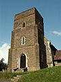
The Church of St Mary, a historic building.
-
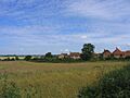
A view of Tysea Hill in Stapleford Abbotts.
See also
 In Spanish: Stapleford Abbotts para niños
