Stanford Rivers facts for kids
Quick facts for kids Stanford Rivers |
|
|---|---|
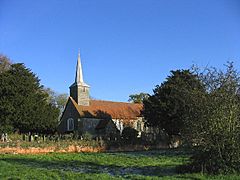 The Church of St Margaret |
|
| Population | 739 (2001) 817 (2011) |
| District |
|
| Shire county | |
| Region | |
| Country | England |
| Sovereign state | United Kingdom |
| Post town | ONGAR |
| Postcode district | CM5 |
| Dialling code | 01277 |
| Police | Essex |
| Fire | Essex |
| Ambulance | East of England |
| EU Parliament | East of England |
| UK Parliament |
|
Stanford Rivers is a lovely village and civil parish in Essex, England. It's part of the Epping Forest district. The parish is about 11 miles (18 km) west of Chelmsford, which is the main town in Essex.
The area includes not just Stanford Rivers village, but also the larger village of Toot Hill and the small areas called Little End and Clatterford End. Stanford Rivers village is about 2 miles (3.2 km) south-east of Chipping Ongar.
If you want to visit by train, the closest London Underground station is Epping, about 5 miles (8 km) to the west. This is the last stop on the Central line. For National Rail trains, Harlow Town Station is about 8 miles (13 km) to the northwest.
Contents
A Look Back in Time: History of Stanford Rivers
The name 'Stanford' comes from an old English word meaning "a stone ford" or "stony ford." A ford is a shallow place in a river where you can cross. Stanford Rivers was mentioned in the Domesday Book in 1086 as 'Stanfort'. Later, in 1289, it was called "Stanford Ryueres" after a family who owned land there.
In the past, Stanford Rivers was described as a parish about three miles south of Ongar station. It was also about seven miles from Brentwood and nineteen miles from London.
People and Places in the Past
The number of people living in Stanford Rivers parish changed over the years. For example, in 1851, there were 1,052 people. By 1931, this number had gone down to 758. From 1891 to 1911, these numbers included people living in the Ongar Union workhouse.
A workhouse was a place where poor people could live and work. It was set up in 1836 to help people who needed support from the government. The Ongar workhouse helped people from 26 nearby villages. Today, the old workhouse building in Little End (part of Stanford Rivers parish) is used for businesses.
The size of the parish land also changed slightly over time. In 1855, it was about 4,386 acres (17.75 km2). By 1933, it was still around 4,405 acres (17.83 km2). Farmers in the area mostly grew wheat, barley, and beans. The soil was often clay or heavy loam.
Schools and Important People
A school for boys and girls was built in 1850. It could hold 190 children. By 1914, it became a Public Elementary School.
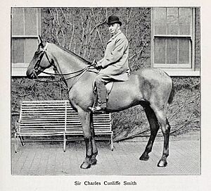
Some important people lived in Stanford Rivers. These included members of the Smith family, like Sir Charles Cunliffe Smith. They owned a lot of land in the area. Another notable person was Isaac Taylor (1787–1865), an artist and writer, who lived at Stanford House.
Local Businesses and Jobs
From 1855 to 1933, there were several pubs in the parish, like the White Bear Hotel and the Toot Hill Green Man. There were also many farmers, some of whom also dealt with cattle or poultry.
Other jobs included shopkeepers, boot and shoe makers, Blacksmiths, and carpenters. In the early 20th century, new businesses appeared, like the Holly Tree Laundry and an Egg Grading Station. There were also millers, who used wind, steam, or water to grind grain.
People also had non-manual jobs, like a registrar (who recorded births and deaths), a head keeper for large estates, and a sanitary inspector for the local council.
Churches in the Parish
The main church in Stanford Rivers is the Church of St Margaret. It's a very old church, with parts dating back to the 12th century. It has a wooden tower and a spire with two bells. Inside, you can see old brass plaques that remember people from long ago, some from the 15th and 16th centuries. The church records go all the way back to 1538!
There was also a Congregational chapel built in 1819 in Little End, but it was sadly destroyed by fire in 1927.
Blake Hall Station: A Quiet Stop
In the past, the closest train station was Blake Hall. It was located north of the parish. This train line opened in 1865 and was mainly used to carry farm goods into London.
From 1949 to 1957, steam locomotives ran a shuttle service from Epping to Ongar, stopping at Blake Hall. Then, the line became electric and was taken over by the Central line.
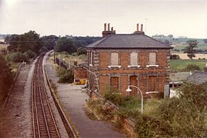
Blake Hall station closed in 1981 because very few people used it. Some reports say only 17 passengers used it each day, making it the quietest station on the entire London Underground! Even though the station building is still there (it's now a private house), trains don't stop there anymore.
Today, the Epping Ongar Railway runs heritage trains on this line. Sometimes, the train will stop outside the old Blake Hall station to give passengers a feel for how it used to be. The station and area were even featured in a TV show called Great British Railway Journeys in 2012.
How Stanford Rivers is Governed
Stanford Rivers is part of the Brentwood and Ongar area. This means its voice in the UK Parliament is represented by an MP (Member of Parliament). Currently, Alex Burghart is the MP for this area.
Locally, Stanford Rivers is looked after by the Stanford Rivers Parish Council. This council has seven members who represent the villages and hamlets in the parish, including Stanford Rivers, Toot Hill, Clatterford End, and Little End. The parish council helps organize local events, like the Country Show.
Who Lives Here: Demographics
| Historical population | ||
|---|---|---|
| Year | Pop. | ±% |
| 1801 | 740 | — |
| 1811 | 700 | −5.4% |
| 1821 | 790 | +12.9% |
| 1831 | 900 | +13.9% |
| 1841 | 965 | +7.2% |
| 1851 | 1,082 | +12.1% |
| 1861 | 1,050 | −3.0% |
| 1871 | 1,000 | −4.8% |
| 1881 | 985 | −1.5% |
| 1891 | 990 | +0.5% |
| 1901 | 905 | −8.6% |
| 1911 | 875 | −3.3% |
| 1921 | 690 | −21.1% |
| 1931 | 755 | +9.4% |
| 1941 | 790 | +4.6% |
| 1951 | 802 | +1.5% |
| 1961 | 836 | +4.2% |
| 1971 | 809 | −3.2% |
| 1981 | 747 | −7.7% |
| 1991 | 779 | +4.3% |
| 2001 | 739 | −5.1% |
| 2011 | 817 | +10.6% |
The table shows how the population of Stanford Rivers parish has changed over many years. In 2001, there were 739 people living in the parish. Most people lived in houses or bungalows.
Most residents in Stanford Rivers are white British. In 2001, 707 people identified as white British.
Christianity is the main religion in the parish. In 2001, about 73.8% of people said they were Christian. About 13.9% said they had no religion.
In 2001, 19 people in the parish were unemployed. Many residents worked in real estate, retail, and construction.
Important Buildings and Places: Landmarks
Stanford Rivers has many historic buildings. There are 90 buildings, cottages, and structures that are listed as Grade II, meaning they are important and protected. Two buildings are even Grade II*, which means they are especially important.
Historic Buildings to See
- St Margaret of Antioch's Church: This is the parish church on School Road. It's a Grade II* listed building, with parts dating back to the 12th century.
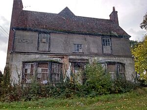
- Littlebury: Also a Grade II* building, this was once a large house from the early 16th century. It's made of brick on the ground floor and timber (wood) above.
- Littlebury Mill: About 140 yards (128 m) south of Littlebury, this is a Grade II listed watermill from around 1840. It used water, then steam, and later electricity to grind grain.
- The Woodman Public House: This pub on London Road is a timber-framed building from the 17th century.
- The White Bear: Next to The Woodman, this building was once The White Bear Hotel. It's an older building, mostly from the 18th and 19th centuries.
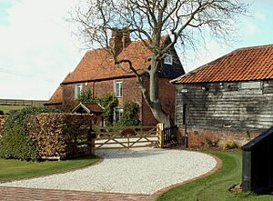
- Stanford Rivers Hall: This Grade II listed house is near St Margaret's Church. It's a red brick house from the 18th and early 19th centuries. The farm nearby, Stanford Hall Farm, also has listed buildings like a farmhouse, barns, and a granary.
- The Old Rectory: On Old Rectory Road, this house is from around 1780. It has an old fire insurance plaque on it. There are also remains of a moat (a ditch, often filled with water, around a building) nearby.
Historic Farmhouses
Many farmhouses in Stanford Rivers are also Grade II listed, often with their old barns and other farm buildings.
Some of these include:
- Traceys Farmhouse: From the 17th century, with parts of a moat.
- Berwick Farmhouse: Dating back to the 15th century.
- Murrells Farmhouse: From the 16th century or even earlier.
- Clarks Farmhouse: A very old "hall house" from the 14th century.
- Does Farmhouse: In Toot Hill, it's a timber-framed house from the 16th century.
These old farmhouses show how long people have been living and farming in Stanford Rivers!
 | Toni Morrison |
 | Barack Obama |
 | Martin Luther King Jr. |
 | Ralph Bunche |


