Sterling Heights, Michigan facts for kids
Quick facts for kids
Sterling Heights, Michigan
|
||
|---|---|---|

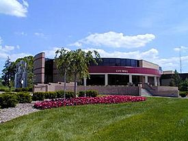
Sterling Heights City Hall
|
||
|
||
| Motto(s):
To Strive on Behalf of All
|
||

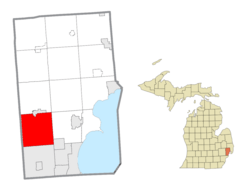
Location within Macomb County
|
||
| Country | United States | |
| State | Michigan | |
| County | Macomb | |
| Incorporated | 1968 (city) | |
| Government | ||
| • Type | Council–manager | |
| Area | ||
| • Total | 36.72 sq mi (95.10 km2) | |
| • Land | 36.45 sq mi (94.40 km2) | |
| • Water | 0.27 sq mi (0.70 km2) | |
| Elevation | 614 ft (187 m) | |
| Population
(2020)
|
||
| • Total | 134,346 | |
| • Density | 3,686.06/sq mi (1,423.18/km2) | |
| Time zone | UTC−5 (Eastern (EST)) | |
| • Summer (DST) | UTC−4 (EDT) | |
| ZIP Codes |
48310, 48311, 48312, 48313, 48314
|
|
| Area code(s) | 586 | |
| FIPS code | 26-76460 | |
| GNIS feature ID | 0638798 | |
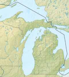
Sterling Heights is a city in Macomb County, Michigan, in the United States. It's a northern suburb of Detroit, located about 18 miles (29 km) north of downtown Detroit. In 2020, the city had a population of 134,346 people. This makes Sterling Heights the second-largest suburb of Detroit and the fourth-most populated city in Michigan.
Contents
Discovering Sterling Heights History
The area that is now Sterling Heights was first surveyed in 1818. This happened after the War of 1812 and a treaty signed in 1817.
How Sterling Heights Got Its Name
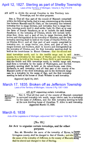
The area was first part of Shelby Township in 1827. It then became Jefferson Township in 1835. In 1838, it was renamed Sterling Township.
Until the 1950s, Sterling Township was mostly farmland. Farmers grew crops like rhubarb to sell in Detroit. As roads improved, it became easier to travel and deliver goods. More people moved to the area when homes were built for workers in Detroit's growing car industry.
When Sterling Township became a city in 1968, "Heights" was added to its name. This was because there was already a small village called Sterling in Michigan. Adding "Heights" made sure the names were different.
Early Leaders and Growth
Gerald Donovan became the first mayor of Sterling Heights. F. James Dunlop was the first mayor pro-tempore (a temporary mayor). In the 1960s and 1970s, many people moved to Sterling Heights to work in car factories like Chrysler and Ford. Lakeside Mall, a large shopping center, opened in the city in 1976.
A Diverse Community
Sterling Heights is home to many different groups of people from around the world. Many residents have roots in Eastern Europe, including people from Albania, Bosnia, Croatia, and Poland. After the 2003 U.S.-Iraqi War, many Iraqi citizens, especially Assyrians, moved to Sterling Heights. Because of this, some parts of the city are even called "Little Nineveh."
Exploring Sterling Heights Geography
Sterling Heights is a suburb located 14 to 20 miles north of downtown Detroit. Its southern border is about 6 miles from Detroit's northern border. The city is about six miles long and six miles wide.
Neighboring Areas
Sterling Heights shares borders with several other cities and townships:
- To the south: Warren
- To the southwest: Madison Heights
- To the west: Troy
- To the north: Utica and Shelby Township
- To the northeast: Macomb Township
- To the east: Clinton Township
- To the southeast: Fraser
Land and Water
The city covers a total area of about 36.72 square miles (95.10 square kilometers). Most of this is land (36.45 sq mi or 94.40 sq km). A small part, about 0.27 square miles (0.70 sq km), is water. The Clinton River flows through the northeast part of the city. It then goes east to Lake St. Clair.
Sterling Heights Climate
Sterling Heights has a humid continental climate. This means it has warm summers and cold winters.
| Climate data for Sterling Heights (Eastpointe station) | |||||||||||||
|---|---|---|---|---|---|---|---|---|---|---|---|---|---|
| Month | Jan | Feb | Mar | Apr | May | Jun | Jul | Aug | Sep | Oct | Nov | Dec | Year |
| Mean daily maximum °C (°F) | 0.4 (32.8) |
2.1 (35.8) |
7.1 (44.7) |
14.6 (58.3) |
20.9 (69.7) |
26.7 (80.0) |
29.0 (84.2) |
27.6 (81.7) |
23.8 (74.8) |
16.8 (62.3) |
9.4 (49.0) |
2.5 (36.5) |
15.1 (59.1) |
| Daily mean °C (°F) | −3.6 (25.5) |
−2.6 (27.3) |
1.7 (35.0) |
8.4 (47.2) |
14.8 (58.6) |
20.5 (68.9) |
22.9 (73.3) |
21.8 (71.3) |
17.7 (63.9) |
11.2 (52.1) |
4.9 (40.8) |
−1.3 (29.7) |
9.7 (49.5) |
| Mean daily minimum °C (°F) | −7.7 (18.2) |
−7.3 (18.8) |
−3.7 (25.3) |
2.2 (36.0) |
8.6 (47.5) |
14.3 (57.7) |
16.8 (62.3) |
16.0 (60.8) |
11.6 (52.9) |
5.5 (41.9) |
0.3 (32.5) |
−5.1 (22.9) |
4.3 (39.7) |
| Average precipitation mm (inches) | 47 (1.86) |
46 (1.82) |
58 (2.27) |
78 (3.07) |
82 (3.23) |
86 (3.38) |
82 (3.22) |
86 (3.38) |
88 (3.45) |
70 (2.75) |
77 (3.05) |
63 (2.49) |
863 (33.97) |
| Source: NOAA (normals 1981–2010) | |||||||||||||
Surrounding Cities and Towns
 |
Rochester Hills Rochester |
Shelby Township Utica |
Macomb Township |  |
| Troy | Clinton Township | |||
| Madison Heights | Warren | Fraser |
Major Roads and Highways
Sterling Heights has important roads that help people travel around.
State Highways
 M-53: This road is also called Van Dyke Avenue or the Van Dyke Freeway. It goes north into the "Thumb" area of Michigan.
 M-59: This road is known as Hall Road. It connects areas from east to west. It's a main road for shopping and businesses in Sterling Heights, especially near Lakeside Mall.
Other Important Roads
- Mound Road: This is a key road that runs north and south through the city.
- Mile Roads: East-west travel mainly uses "mile roads," like 14 Mile Road through 20 Mile Road (M-59). 16 Mile Road, also called Metro Parkway, is another big "mile road."
- Utica Road: This road cuts diagonally across the city. It goes past the Sterling Heights city hall.
- Dequindre Road: This road forms the border between Sterling Heights and Troy. It also separates Macomb County from Oakland County.
- Hayes Road: This road divides Clinton Township and Fraser in certain areas.
Population of Sterling Heights
The city's population has grown a lot over the years.
| Historical population | |||
|---|---|---|---|
| Census | Pop. | %± | |
| 1940 | 3,648 | — | |
| 1950 | 6,509 | 78.4% | |
| 1960 | 14,622 | 124.6% | |
| 1970 | 61,365 | 319.7% | |
| 1980 | 108,999 | 77.6% | |
| 1990 | 117,810 | 8.1% | |
| 2000 | 124,471 | 5.7% | |
| 2010 | 129,699 | 4.2% | |
| 2020 | 134,346 | 3.6% | |
| U.S. Decennial Census 2018 Estimate |
|||
2020 Census Information
The 2020 census showed that Sterling Heights had 134,346 people. The table below shows the different racial and ethnic groups living in the city.
| Race / Ethnicity (NH = Non-Hispanic) | Pop 2000 | Pop 2010 | Pop 2020 | % 2000 | % 2010 | % 2020 |
|---|---|---|---|---|---|---|
| White alone (NH) | 111,743 | 108,750 | 106,149 | 89.77% | 83.85% | 79.01% |
| Black or African American alone (NH) | 1,602 | 6,638 | 8,709 | 1.29% | 5.12% | 6.48% |
| Native American or Alaska Native alone (NH) | 239 | 246 | 200 | 0.19% | 0.19% | 0.15% |
| Asian alone (NH) | 6,100 | 8,713 | 10,935 | 4.90% | 6.72% | 8.14% |
| Pacific Islander alone (NH) | 35 | 16 | 13 | 0.03% | 0.01% | 0.01% |
| Other race alone (NH) | 122 | 158 | 337 | 0.10% | 0.12% | 0.25% |
| Mixed race or Multiracial (NH) | 2,965 | 2,655 | 4,728 | 2.38% | 2.05% | 3.52% |
| Hispanic or Latino (any race) | 1,665 | 2,523 | 3,275 | 1.34% | 1.95% | 2.44% |
| Total | 124,471 | 129,699 | 134,346 | 100.00% | 100.00% | 100.00% |
2010 Census Information
In 2010, there were 129,699 people living in Sterling Heights. About 85.1% were White, 5.2% African American, and 6.7% Asian. About 1.9% of the population identified as Hispanic or Latino.
The average age in the city was 40.4 years. About 21.7% of residents were under 18 years old.
Education in Sterling Heights
Sterling Heights has two public school districts:
- Utica Community Schools: This district serves the northern part of the city. It includes Stevenson High School and Henry Ford II High School.
- Warren Consolidated Schools: This district serves the southern part of the city. It includes Sterling Heights High School.
There is also a private Christian school called Parkway Christian School for students from kindergarten through 12th grade.
Media and Communication
Sterling Heights has several ways for residents to stay informed.
Local Newspapers
The city has three local newspapers:
- The Macomb Daily: This newspaper is delivered daily and on Sundays.
- Sterling Heights Sentry (C and G Newspapers)
- Sterling Heights Source (Advisor & Source Newspapers)
The last two newspapers are delivered to homes in the city for free.
Local TV Channels
The city also has two local TV channels:
- SHTV: This channel is run by the city. It shows local programs, including City Council meetings, and community announcements. You can find SHTV on Comcast channel 5, Wide Open West channel 10, and online.
- Sterling Heights Public Library Channel: This channel shows educational programs and announcements from the library. It's on Comcast channel 12 and WOW channel 20.
Radio and Publications
The city's official radio station is AM 1700. Sterling Heights also sends out a seasonal magazine and a city calendar to every home and business for free. WKEG, a radio station linked with Relevant Radio, is also based in Sterling Heights.
Sister Cities Around the World
Sister City programs help people from different cities learn about each other's cultures. These programs encourage cultural, educational, business, and technical exchanges. Sterling Heights has sister cities in various countries:
 Tetovo, North Macedonia (1982)
 Legazpi, Philippines (1999)
 Cassino, Italy (2006)
 Sorsogon City, Philippines (2008)
 Sant'Elia Fiumerapido, Italy (2010)
 Shëngjin, Albania (2013)
 Jaffna, Sri Lanka (2016)
 Ankawa, Iraq (2024)
Notable People from Sterling Heights
Many talented people have lived in Sterling Heights, including:
- Pete Chryplewicz, a former NFL player
- Shawn Hunwick, a retired NHL goaltender
- Tom Jankiewicz, a screenwriter who grew up in Sterling Heights
- Craig Krenzel, a former NFL player
- Kalin Lucas, a former NBA player
- Greg Pateryn, an NHL defenseman
- Porcelain Black (Alaina Marie Beaton), an industrial pop singer
- Frank Zombo, an NFL linebacker for the Kansas City Chiefs
See also
 In Spanish: Sterling Heights para niños


