Strelley, Nottingham facts for kids
Quick facts for kids Strelley |
|
|---|---|
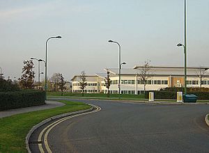
 Nottingham Business Park in November 2007 |
|
| Population | 2,561 |
| OS grid reference | SK 51765 42384 |
| District | |
| Shire county | |
| Region | |
| Country | England |
| Sovereign state | United Kingdom |
| Post town | NOTTINGHAM |
| Postcode district | NG8 |
| Dialling code | 0115 |
| Police | Nottinghamshire |
| Fire | Nottinghamshire |
| Ambulance | East Midlands |
| EU Parliament | East Midlands |
| UK Parliament |
|
The Strelley Estate is a neighborhood in the City of Nottingham, England. It was built after World War II to provide homes for people. You can find it about 3.5 miles (5.6 km) west of the city center. The estate is located in the Bilborough area. In 2001, about 2,561 people lived here.
Contents
What Can You Find in Strelley Estate?
The Strelley Estate has many useful places for its residents. Along Strelley Road, you'll find an Asda supermarket where people can buy groceries. There's also The Rose Inn, a local pub, and a police station. A recreation ground is nearby, perfect for outdoor activities.
Shops and Schools in Strelley
On Flamsteed Road, there's a fish and chip shop, a Premier convenience store, and a chemist for medicines. For education, the Djanogly Strelley Academy is located off Cranwell Road.
Businesses and Hotels in the Area
The estate also includes the Nottingham Business Park. This is a place where many companies have their offices. The Nottingham Belfry hotel is right next to the business park. New houses have also been built around Princess Boulevard.
Who Lives in Strelley Estate?
In 2001, the Strelley Estate had a population of 2,561 people. Most of the people living there were between 25 and 44 years old. This age group made up almost 30% of the population.
Different Backgrounds in Strelley
The census also showed that most residents, about 91.8%, were White British. A smaller number of people were White Irish or from other White backgrounds. About 3.1% of the population was Mixed Race. There were also people of Asian or Black backgrounds living in the estate.
What Religions Are Practiced in Strelley?
According to the 2001 census, most people in Strelley Estate, about 65.8%, were Christian. A good number of people, 23%, said they were Atheists, meaning they do not believe in a god.
Places of Worship in Strelley
Smaller groups practiced other religions like Hinduism, Islam, Sikhism, and Buddhism. About 8.8% of the people did not share their religion. The Ark Church is on Strelley Road, and the Kingdom Hall of Jehovah's Witnesses Church is on Flamsteed Road.
How to Get Around Strelley Estate?
Strelley Estate is well-connected by local bus services. These buses make it easy for residents to travel to different parts of Nottingham.
Nottingham City Transport Buses
- ■ 35: This bus goes from Nottingham city center to Bulwell, passing through Strelley. It also stops at the QMC and University Park.
- ■ 35B: This route is similar to the 35, connecting Nottingham city center to Strelley.
- ■ 77: This bus travels from Nottingham city center to Strelley via Alfreton Road and Aspley Lane.
- ■ 77C: This route extends from Strelley to Cinderhill.
- ■ 78: This bus connects Nottingham city center to Strelley, going through the Broxtowe Estate.
CT4N Bus Services
- ■ L2: This bus goes from Nottingham city center to the Nottingham Business Park in Strelley, and then on to Assarts Farm Estate.
- ■ L4: This route connects Nottingham city center to Strelley, passing through Beechdale.
 | John T. Biggers |
 | Thomas Blackshear |
 | Mark Bradford |
 | Beverly Buchanan |


