Taal Volcano facts for kids
Quick facts for kids Taal Volcano |
|
|---|---|
| Bulkang Taal | |
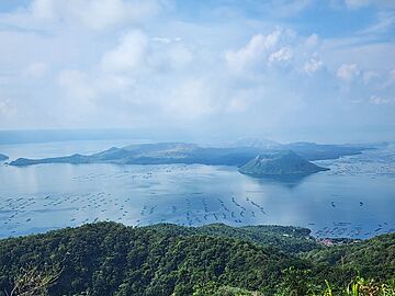
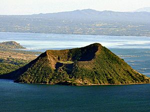
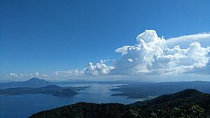
Volcano Island, located within the lake that constitutes the caldera of Taal Volcano, viewed from Tagaytay (taken in June 2024)
|
|
| Highest point | |
| Elevation | 311 m (1,020 ft) |
| Geography | |
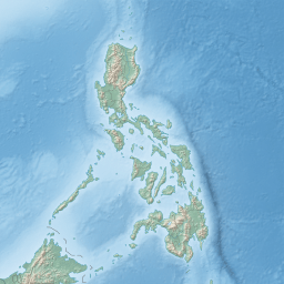
| Location | Talisay and San Nicolas, Batangas, Philippines |
| Geology | |
| Mountain type | Caldera |
| Volcanic arc | Luzon Volcanic Arc |
| Last eruption | December 3, 2024 |
| Climbing | |
| Easiest route | Daang Kastila (Spanish Trail) |
Taal Volcano (Tagalog: Bulkang Taal) is a large caldera (a big, bowl-shaped hollow formed after a volcano erupts and collapses) filled by Taal Lake in the Philippines. It's located in the province of Batangas, about 50 kilometers (31 miles) south of Manila. This volcano is the second most active in the Philippines. It has erupted 38 times in recorded history. All these eruptions happened on Volcano Island, which is in the middle of Taal Lake. The large caldera was created by huge eruptions long ago, between 140,000 and 5,380 years ago.
Taal Volcano has had several powerful eruptions. These eruptions have caused deaths on the island and in the towns around the lake. About 6,000 people have died because of Taal's eruptions. Because it's so close to many towns and has a history of big eruptions, Taal Volcano is known as a Decade Volcano. This means it's one of the most important volcanoes to study closely to help prevent future natural disasters. In 1998, it was named a National Geological Monument. Then, in 2018, it became a national park.
Contents
What's in a Name?
In the 1800s, Taal Volcano was called Bombou or Bombon.
The town of Taal and the Taa-lan River (now called Pansipit River) got their names from the Taa-lan tree. This tree grows along the river and also along the shore of Bombon Lake (now Taal Lake). The Taa-lan River was a narrow waterway that connected Taal Lake to Balayan Bay.
The word Taal comes from the Tagalog word in the Batangueño dialect. It means true, genuine, or pure.
Where is Taal Volcano?
Taal Volcano is part of a line of volcanoes along the western side of Luzon island. These volcanoes formed when one of Earth's large plates, the Eurasian Plate, slid under another, the Philippine Mobile Belt. Taal Lake sits inside a caldera that is about 25 to 30 kilometers (15 to 19 miles) wide. This caldera was formed by huge, explosive eruptions between 140,000 and 5,380 years ago. These eruptions left behind thick layers of volcanic rock and ash, reaching as far as present-day Manila.
Taal Volcano and its lake are entirely within the province of Batangas. The northern part of Volcano Island is in the town of Talisay. The southern part is in San Nicolas. Many other towns and cities also surround Taal Lake.
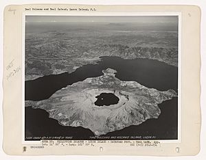
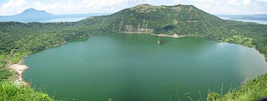
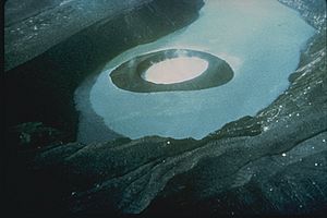
After the caldera formed, later eruptions created a new volcanic island inside it. This island is called Volcano Island. It's about 5 kilometers (3 miles) wide and covers about 23 square kilometers (9 square miles). In the center of the island is the Main Crater, which is 2 kilometers (1.2 miles) wide. It has a lake inside it that formed after the 1911 eruption. Volcano Island has 47 different cones and craters. Twenty-six of these are tuff cones (formed by ash), five are cinder cones (formed by lava fragments), and four are maars (wide, flat craters). The Main Crater Lake on Volcano Island is unique. It's the largest lake on an island, which is inside a lake, which is on another island in the world! This lake used to have a small rocky island inside it called Vulcan Point. After the 2020 eruption, the Main Crater Lake disappeared for a short time. But it returned by March 2020.
The Philippine Institute of Volcanology and Seismology (PHIVOLCS) has made Volcano Island a "Permanent Danger Zone" (PDZ). This means people are not allowed to live there because it's a high-risk area. Even with these warnings, some families still live on the island. They earn money by fishing and farming in the rich volcanic soil.
Wildfires on the Island
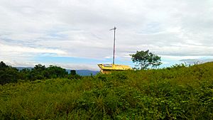
On May 6, 2024, the governor of Batangas, Hermilando Mandanas, said that Volcano Island was a "no man's land." This was because of several wildfires that happened on the island's southwest tip on May 2. These fires were near the Binintiang Munti observation station.
Volcano Eruptions
Taal Volcano has a long history of eruptions.
Before the 1900s
There were 54 recorded eruptions at Taal between 1572 and 1977. The first eruption recorded happened in 1572. This was the same year that Augustinian friars started the town of Taal on the lake's shores. In 1591, a small eruption happened, sending out lots of smoke. From 1605 to 1611, the volcano was very active.
Between 1707 and 1731, the volcano's activity moved from the Main Crater to other parts of Volcano Island. The eruptions in 1707 and 1715 happened at the Binintiang Malaki (Giant Leg) crater. This is a cinder cone you can see from Tagaytay Ridge. These eruptions came with thunder and lightning. Smaller eruptions also happened at the Binintiang Munti crater on the western tip of the island in 1709 and 1729. A more powerful eruption happened on September 24, 1716. It blew out the southeastern part of the Calauit crater. One observer noted that the 1716 eruption "killed all the fishes...as if they had been cooked." This was because the water became very hot. The 1731 eruption off Pira-Piraso, on the eastern tip of the island, even created a new island.
The Main Crater became active again on August 11, 1749. Its eruptions were very strong until 1753. Then came the huge 200-day eruption of 1754. This was Taal Volcano's biggest recorded eruption. It lasted from May 15 to December 12. This eruption forced people to move the towns of Tanauan, Taal, Lipa, and Sala. The Pansipit River was blocked, which made the lake's water level rise. One account said that of Taal town, "nothing was left...except the walls of the church and convent." Everything else was buried under stones, mud, and ashes.
After this huge eruption, Taal Volcano was quiet for 54 years, except for a small eruption in 1790. Another big eruption happened in March 1808. This one was not as strong as the 1754 eruption. But it covered the nearby area with ashes almost a meter (33 inches) deep. This eruption greatly changed the inside of the crater. Before this eruption, the crater floor was very deep. After it, the crater became wider. The pond inside it became one-third smaller, and the rest of the crater floor was dry enough to walk on.
On July 19, 1874, an eruption of gases and ashes killed all the animals on Volcano Island. From November 12 to 15, 1878, ashes from the volcano covered the entire island. Another eruption happened in 1904. This created a new opening in the main crater's southeastern wall. Before 2020, the last eruption from the main crater was in 1911. That eruption destroyed the crater floor, creating the lake we see today. In 1965, a huge explosion broke off a large part of the island. This moved the volcano's activity to a new center called Mount Tabaro.
The 1911 Eruption
One of Taal's most destructive eruptions happened in January 1911. On the night of January 27, seismographs (machines that detect earthquakes) in Manila Observatory started recording frequent tremors. These tremors quickly grew stronger. On January 28, 217 separate tremors were recorded. Many people in Manila were worried by the frequent earthquakes. But the observatory staff quickly found that the quakes were coming from Taal Volcano. They told the public that Manila was safe, as Taal was about 60 kilometers (37 miles) away.
In Manila, early on January 30, people woke up to what sounded like loud thunder. This seemed even more real when lightning lit up the southern sky. A huge, fan-shaped cloud of what looked like black smoke rose very high. It was filled with bright volcanic lightning. This cloud then shot up, spread out, and disappeared. This marked the peak of the eruption, around 2:30 AM.
On Volcano Island, everything was destroyed. When the black, fan-shaped cloud spread, it seemed to create a powerful downward blast. This blast pushed hot steam and gases down the crater's slopes. It also brought a shower of hot mud and sand. Many trees had their bark ripped off by the hot sand and mud. This shower caused most of the deaths and destruction around the volcano. The fact that almost all the plants were bent away from the crater suggests a very strong blast went down the outside slopes. Very few plants were actually burned. Six hours after the explosion, dust from the crater could be seen in Manila. It settled on furniture and other surfaces. The solid material that erupted was huge, about 70 to 80 million cubic meters (2.5 to 2.8 billion cubic feet). Ash fell over an area of 2,000 square kilometers (770 square miles). But the area where real destruction happened was only 230 square kilometers (89 square miles). The sound of the explosion was heard over an area more than 600 miles (966 kilometers) wide.
How Many People Died?
The 1911 eruption killed about 1,100 people and injured 199. However, it's thought that more people died than the official records show. The seven villages on the island before the eruption were completely wiped out. Studies of the victims showed that almost all died from being scalded by hot steam or hot mud. The powerful blast also reached the west shore of the lake, destroying several villages there. 702 cattle died, and 543 traditional houses were destroyed. Crops were damaged by the ash, which fell almost half an inch deep in some places near the lake shore.
What Happened After?
Volcano Island sank between 1 and 3 meters (3 and 10 feet) because of the eruption. The southern shore of Lake Taal also sank. No lava was found anywhere, and geologists haven't found any signs of lava flowing during the eruption. Another interesting fact about Taal is that no sulfur has been found on the volcano. The yellow deposits in the crater are iron salts, not sulfur. A slight smell of sulfur came from gases escaping the crater.
Big changes happened in the crater after the eruption. Before 1911, the crater floor was higher than Taal Lake. It had several separate openings with lakes of different colors: green, yellow, and red. There were also holes with hot water and steam. Many areas were covered with a shaky crust of volcanic material, which was hot and dangerous to walk on. Right after the explosion, the colored lakes disappeared. In their place was one large lake, about 3 meters (10 feet) lower than the main Taal Lake. This crater lake slowly rose to the same level as Taal Lake. People used to think that the water in the crater cooled the material below, making eruptions less likely. But experts now say this isn't true. The later eruptions in 1965 and after came from a new eruption center, Mount Tabaro.
Ten years after the eruption, the island's overall shape looked the same from a distance. But on the island itself, many changes were seen. Plants had grown back. Large areas that were once bare and covered with white ash and cinders were now covered with plants.
Eruptions from 1965 to 1977
Taal had another period of volcanic activity from 1965 to 1977. During this time, most of the activity was around Mount Tabaro. The 1965 eruption was a phreatomagmatic eruption. This happens when hot magma mixes with water, causing a violent explosion. This explosion created a large indentation on Volcano Island. The eruption also produced "cold" base surges (fast-moving clouds of gas and debris). These surges traveled several kilometers across Taal Lake, destroying villages on the lake shore and killing about a hundred people.
One American geologist, who had seen an atomic bomb explosion, visited the volcano soon after the 1965 eruption. He recognized the "base surge" (now called pyroclastic surge) as a type of volcanic eruption process.
Warning signs before the eruption were not fully understood until after it happened. People living on the island were only moved to safety after the eruption had already started.
After nine months of quiet, Taal became active again on July 5, 1966. Another phreatomagmatic eruption happened from Mount Tabaro. This was followed by a similar eruption on August 16, 1967. Strombolian eruptions (which produce lava fountains) started five months later, on January 31, 1968. These were the first historical lava fountains seen from Taal. Another Strombolian eruption followed on October 29, 1969. The large lava flows from these two eruptions eventually filled the bay created by the 1965 eruption, reaching the shore of Taal Lake. The last major activities during this period were the phreatic eruptions (steam-driven explosions) in 1976 and 1977.
Recent Activity: 2000s to Today
Since the 1977 eruption, the volcano has shown signs of unrest since 1991. There has been strong earthquake activity and cracks forming in the ground. Small mud pots (pools of boiling mud) and mud geysers have also appeared on parts of the island. The Philippine Institute of Volcanology and Seismology (PHIVOLCS) regularly gives updates and warnings about Taal's activity.
2008 and 2010
On August 28, 2008, PHIVOLCS reported 10 volcanic earthquakes. On June 8, 2010, PHIVOLCS raised the volcano's status to Alert Level 2. This meant that magma was moving underground, which could lead to an eruption. PHIVOLCS warned people that the Main Crater was dangerous because of possible steam explosions and toxic gases. Areas with hot ground and steam, like parts of the Daang Kastila Trail, were also risky.
2011
From April 9 to July 5, 2011, Taal Volcano's alert level was raised from 1 to 2. This was because of increased earthquake activity on Volcano Island. On May 30, there were about 115 tremors, some strong enough to cause rumbling sounds. Magma was moving closer to the surface. This was shown by high levels of carbon dioxide gas coming from the Main Crater Lake and ongoing earthquake activity.
2019 to 2022 Eruptions
2019
In 2019, Alert Level 1 was put in place because of frequent volcanic activity. For example, between November 11 and 12, 57 volcanic earthquakes were recorded.
2020 Eruption
The volcano erupted on the afternoon of January 12, 2020. PHIVOLCS quickly raised the alert level from 2 to 4. This was an eruption from the main crater on Volcano Island. The eruption sent ash high into the sky. This ash fell on Calabarzon, Metro Manila, parts of Central Luzon, and Pangasinan. Because of the ashfall, schools, work, and flights were canceled. There were also reports of volcanic thunderstorms and warnings of a possible volcanic tsunami. The volcano produced volcanic lightning above its crater within the ash clouds. The eruption then became a magmatic eruption. This means it produced a lava fountain with thunder and lightning. By January 26, 2020, PHIVOLCS saw that the volcano's activity was decreasing. So, they lowered the warning to Alert Level 3. On February 14, it was lowered again to Alert Level 2. A total of 39 people died in this eruption. Most died because they didn't want to leave their homes or had health problems during the evacuation.
2021 and 2022 Activity
In February 2021, people living on Taal Volcano Island were moved to safety because the volcano was becoming more active. On March 9, 2021, PHIVOLCS raised the alert level from 1 to 2. In June, the volcano released a lot of sulfur dioxide gas. This caused vog (volcanic smog) to appear over nearby provinces and even Metro Manila. On July 1, the volcano erupted around 3:16 PM, and the alert level went up to Level 3. Five more eruptions were recorded on July 7. On July 23, PHIVOLCS lowered the alert level back to Level 2.
Between January 29 and 30, 2022, the volcano had nine phreatomagmatic bursts from its main crater. On March 26, PHIVOLCS raised the alert level to 3. This was due to a short phreatomagmatic eruption. About 1,100 residents around the area were moved to safety. Two phreatomagmatic events were recorded, sending toxic plumes of ash 800 meters (2,600 feet) and 400 meters (1,300 feet) high. Locals reported an explosion near the crater around 1:00 PM, with ash spreading around the lake. High levels of toxic gases were also recorded. The next day, March 27, volcanic activity was quieter. On April 9, PHIVOLCS lowered the alert level back to Level 2. It was then lowered further to Alert Level 1 on July 11.
On August 3, 2022, PHIVOLCS noted low-level unrest with an increase in sulfur dioxide (SO2) gas. An unusually high amount of sulfur, up to 12,125 tons, was measured that day. Volcanic smog, or vog, and toxic gases were seen in Batangas and nearby towns since August 2.
2023 and 2024 Activity
In June 2023, sulfur dioxide levels around the volcano greatly increased. This caused a vog that forced schools to close in Laurel and Talisay, and parts of Agoncillo. On June 29, PHIVOLCS recorded a phreatic burst that lasted for just over a minute. In mid-September, the volcano released the same vog as in June. This also caused schools to close in Batangas and nearby areas. The vog was released at an average of 3,402 tons per day.
In June 2024, five volcanic earthquakes were reported. These caused several phreatic eruptions over 24 hours. They released 1,072 tons of sulfur dioxide into the air. Taal Volcano was under Alert Level 1 in September when several small eruptions happened.
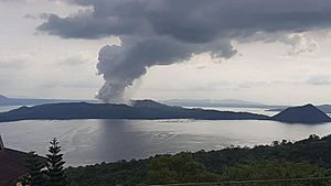
On October 2, 2024, another series of small phreatic eruptions were reported. They lasted between two and six minutes. The volcano then had a phreatomagmatic eruption, sending a plume 2,400 meters (7,900 feet) high. The Alert Level 1 status remained unchanged. Two more small phreatomagmatic eruptions happened on October 5 and October 10. Two more phreatic eruptions were reported on October 16. On December 3, a small phreatomagmatic eruption was reported at 5:58 AM. It produced a grayish plume that reached 2,800 meters (9,200 feet) high.
How Taal Volcano is Monitored
Alert Levels
PHIVOLCS uses a special Alert Level system for six volcanoes in the Philippines, including Taal Volcano. There are six levels, from 0 to 5.
| Alert Level | What it Means | What's Happening |
|---|---|---|
| 0 | Normal | The volcano is quiet. No major eruption is expected soon. But small steam or gas eruptions can happen without warning. |
| 1 | Low-level unrest | Activity might be happening deep inside the volcano. Steam, gas, or hydrothermal explosions can happen without warning. |
| 2 | Increasing unrest | Activity is increasing, possibly with magma moving closer to the surface. There's a higher chance of steam, gas, or hydrothermal explosions. |
| 3 | Intensified unrest/Magmatic unrest | A magma-driven or explosive steam-and-magma eruption is about to happen. Early eruption signs might be seen, like ashfall or small lava flows. |
| 4 | Hazardous eruption imminent | A strong steam-and-magma or magma-driven eruption is happening. This might lead to a very explosive eruption. Widespread ashfall, flying rocks, lava flows, and small pyroclastic flows (hot gas and rock) might occur on Volcano Island. |
| 5 | Highly Hazardous eruption in progress | A very dangerous, large eruption is happening. Extreme life-threatening hazards like fast-moving hot gas and ash clouds, volcanic tsunamis, thick ashfall, ground cracks, mudflows, and landslides could affect towns around the lake and downwind of the ash cloud. |
Signs of an Eruption
Volcanologists look for several signs that Taal Volcano might erupt:
- More frequent earthquakes, sometimes with rumbling sounds.
- Changes in the Main Crater Lake's water. This includes changes in temperature, water level, or bubbling. Before the 1965 eruption, the lake's temperature rose by about 15 degrees Celsius (27 degrees Fahrenheit).
- New hot areas appearing, like fumaroles (steam vents), geysers (hot water spouts), or mudpots (boiling mud pools).
- The ground swelling or cracking.
- Increased temperature in monitoring holes in the ground.
- A strong smell of sulfur, like rotten eggs.
- Fish dying and plants drying up.
Other Possible Signs
In October 1994, volcanologists measured the amount of radon gas in the soil on Volcano Island. They found that the radon levels increased six times more than usual. This increase was followed 22 days later by a magnitude 7.1 Mindoro earthquake on November 15. This earthquake was about 50 kilometers (31 miles) south of Taal. A typhoon had passed through the area a few days before the radon spike. But when Typhoon Angela, a very powerful typhoon, crossed Luzon a year later, no radon spike was measured. This showed that typhoons were not the cause. It strongly suggests that the radon increase came from stress building up before the earthquake.
|
See also
 In Spanish: Volcán Taál para niños
 | Roy Wilkins |
 | John Lewis |
 | Linda Carol Brown |


