
Tennessee–Tombigbee Waterway facts for kids

The Tennessee–Tombigbee Waterway, often called the Tenn-Tom, is a 234-mile (377 km) long man-made waterway in the United States. It was built in the 20th century to connect the Tennessee River with the Black Warrior-Tombigbee River system near Demopolis, Alabama. This important waterway helps boats carry goods from the middle of the country all the way to the Gulf of Mexico.
The Tenn-Tom has 234 miles (377 km) of navigation channels. It also features a 175-foot-deep (53 m) cut through the land that separates the two river systems. There are ten locks and dams along the waterway. These locks are 9 by 110 by 600 feet (2.7 m × 33.5 m × 182.9 m) in size, which is the same as some locks on the Mississippi River.
The U.S. Army Corps of Engineers built the Tenn-Tom over 12 years. It was finished in December 1984 and cost almost $2 billion. The Tenn-Tom includes 17 public ports and terminals. It also has 110,000 acres (450 km2) of land and another 88,000 acres (360 km2) managed by state agencies. This land is used to protect wildlife habitat and for fun outdoor activities.
Contents
Building the Tenn-Tom: A Look Back
The idea for a waterway connecting the Tennessee and Tombigbee rivers came up a very long time ago. But it wasn't until the early 1800s, when steamboats became popular, that people started thinking seriously about it. Steamboats made trade much easier and cheaper. This meant products could get to the Gulf Coast for shipping overseas.
In 1875, engineers studied a possible route for the canal. However, they said it would be too expensive to build. So, the project was put on hold for many years.
New Deal and Waterway Plans
Interest in the waterway grew again during the time of President Franklin D. Roosevelt. He became president during the Great Depression, a time when many people did not have jobs. President Roosevelt believed in building big projects to create jobs.
The Tennessee Valley Authority (TVA) developed the Tennessee River. They built dams like the Pickwick Lock and Dam in 1938. This dam was designed with a special area on its south side. This area was meant to be the entrance for a future waterway leading to the Tombigbee River. Building these dams made the Tenn-Tom project seem more possible and useful.
Later, the Kentucky Dam was built near where the Tennessee River meets the Ohio River. This completed the "northern" part of the future waterway.
Starting Construction
In 1971, President Richard Nixon supported the project. He included $1 million in the budget to begin building the Tenn-Tom. There were some delays with money and legal issues. But President Nixon's efforts officially started the construction of the Tenn-Tom waterway in December 1972.
The U.S. Army Corps of Engineers began their work. They had to dig very deep, about 175 feet (53 m) in some places. They moved nearly 310 million cubic yards of soil. That's like more than 100 million dump truck loads! The project was finished on December 12, 1984. This was almost two years earlier than planned.
How the Tenn-Tom Helps the Economy
When it was finished, the Tenn-Tom waterway cost about $1.992 billion. Some people thought it was a waste of money at first. For the first few years, not many boats used the waterway. This was because the shipping business was going through a tough time.
However, a drought in 1988 changed things. The Mississippi River closed because of low water. This made many boats use the Tenn-Tom canal instead. At the same time, the economy in the Tenn-Tom area started to improve. More and more trade and businesses began to use the waterway.
The two main products shipped on the Tenn-Tom are coal and timber. These two make up about 70 percent of all commercial shipping. The Tenn-Tom also provides access to over 34 million acres (140,000 km2) of commercial forests. It also reaches about two-thirds of the country's coal reserves. Businesses that use these natural resources find the waterway to be the cheapest way to transport their goods. Other popular products carried on the Tenn-Tom include grain, gravel, sand, and iron.
A study in 2009 found that the waterway had brought in almost $43 billion in economic benefits to the United States. It also helped create more than 29,000 jobs. The study also showed that the waterway was replacing about 284,000 truckloads each year.
The Divide Cut: Connecting the Rivers

The Divide Cut is a 29 mi (47 km) long canal. It is a very important part of the Tenn-Tom. This cut connects Pickwick Lake on the Tennessee River to Bay Springs Lake. The Divide Cut carries the waterway between two different river systems. One system, the Tennessee River, eventually flows into the Ohio River. The other, the Tombigbee River, flows into the Gulf of Mexico at Mobile.
Pickwick Lake is a popular place for water sports. People enjoy activities like waterskiing and wakeboarding there.
To build the Divide Cut, the entire town of Holcut, Mississippi, had to be moved. Today, the Holcut Memorial is located next to the waterway. It marks the spot where the town used to be.
Locks and Dams Along the Waterway
The Tenn-Tom waterway has ten locks. They are listed below from north to south. Many of them are named after politicians who helped support the project. Locks are like water elevators that help boats move up or down between different water levels.
- Jamie Whitten Lock and Dam; this lock was formerly called Bay Springs Lock and Dam. It creates Bay Springs Lake.
- G. V. Montgomery Lock; this lock was formerly called Lock E.
- John Rankin Lock; this lock was formerly called Lock D.
- Fulton Lock; this lock is in Fulton, Mississippi, and was formerly called Lock C.
- Glover Wilkins Lock; this lock is in Smithville, Mississippi, and was formerly called Lock B.
- Amory Lock; this lock is in Amory, Mississippi, and was formerly called Lock A.
- Aberdeen Lock and Dam; this lock is in Aberdeen, Mississippi. It creates Aberdeen Lake.
- John C. Stennis Lock and Dam; this lock was formerly called Columbus Lock and Dam. It creates Columbus Lake.
- Tom Bevill Lock and Dam; this lock was formerly called Aliceville Lock and Dam. It creates Aliceville Lake.
- Howell Heflin Lock and Dam; this lock was formerly called Gainesville Lock and Dam. It creates Gainesville Lake.
Gallery
-
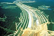
The Divide Cut being built in the early 1980s
-
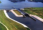
Amory Lock in Amory, Mississippi
-
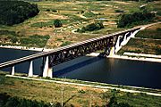
An Illinois Central Railroad (IC) bridge crossing the waterway
-
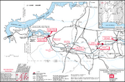
A detailed map of the Divide Cut from the Corps of Engineers


