
Thistle, Utah facts for kids
Quick facts for kids
Thistle, Utah
|
|
|---|---|

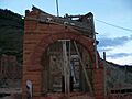
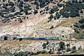
Remnants of the Thistle schoolhouse, September 2006
|
|

Thistle, Utah
Location in Utah

Thistle, Utah
Location in the United States
|
|
| Country | United States |
| State | Utah |
| County | Utah |
| Established | 1878 |
| Destroyed | 1983 |
| Named for | Thistle |
| Elevation | 5,043 ft (1,537 m) |
| Zip code |
84629
|
| GNIS feature ID | 1439662 |
Thistle is a ghost town in Spanish Fork Canyon, located in southeastern Utah County, Utah, United States. A ghost town is a place where most people have left, and only a few buildings remain.
When trains ran on steam locomotives, Thistle's main job was to help service these trains for the Denver and Rio Grande Western Railroad. The town's success was tied to the railroad. But when trains started using diesel locomotives, Thistle began to shrink.
In April 1983, a huge landslide blocked the Spanish Fork River. This caused a lot of water to back up, creating a lake that flooded the town. Everyone had to leave. Thistle was destroyed, with only a few buildings left standing.
Government groups have called this landslide the most expensive in United States history. It affected the economy of the whole area. It was also the first time a US president declared a disaster area in Utah because of a landslide.
U.S. Route 6 (US‑6), U.S. Route 89 (US‑89), and the railroad (now part of Union Pacific Railroad) were closed for months. They were rebuilt on higher ground, overlooking the flooded town. You can still see what's left of Thistle from a view area along US‑89 or from the California Zephyr passenger train.
Contents
Where Was Thistle Located?
Thistle was about 65 miles (105 km) southeast of Salt Lake City. It was where two streams, Thistle Creek and Soldier Creek, joined to form the Spanish Fork River. This spot was also where two natural paths crossed the mountains of central Utah.
These natural paths became routes for trails, highways, and railroads. Important roads like US‑6 and US‑89, and the Denver and Rio Grande Western Railroad line, all passed through Thistle.
A Brief History of Thistle
_C.R._Savage_Photo..jpg)
The area where Thistle was built was a trade route for Native American tribes. Two Ute chiefs, Taby and Peteetneet, used to lead their tribes through the canyon. The first Europeans to visit were explorers in 1776.
Most people living in Thistle worked for the railroad. But some families had settled there even before the trains arrived. The Pace family, for example, came in 1848 as part of the Mormon migration to Utah. Other settlers came to farm on Billies Mountain. A small group of Utes lived in the canyon but were moved in the 1870s.
People farmed and ranched in Thistle until the early 1900s. There was also some mining for a material called asphaltum between 1892 and 1914.
How Railroads Shaped Thistle
The first railroad track was laid through Thistle in 1878. It was a narrow-gauge line that went to coal mines. By 1890, the Denver and Rio Grande Western Railroad (D&RGW) owned the line and made it a standard size. This connected Salt Lake City to Denver.
The railroad built many facilities in Thistle. They added extra engines, called helper engines, to trains going uphill towards Soldier Summit. Thistle also had places where train passengers could eat meals.

More trains came through Thistle when the Marysvale Branch line was built. This line went south from Thistle to mines near Marysvale. Another railroad, the Utah Railway, also built a line through Thistle. Eventually, these two lines were combined.
Thistle grew because the D&RGW worked with other railroads. This made the line through Thistle a key route for trains crossing the country. The town's growth was strongly linked to the success of steam trains.
At its busiest, around 1917, Thistle had about 600 residents. It had a roundhouse for trains, a depot, a machine shop, and places to refuel trains. The town also had stores, a post office, a barber shop, and restaurants. The largest building was a two-story schoolhouse, built in 1911.
In the 1950s, the D&RGW started using diesel locomotives instead of steam trains. Diesel trains needed less maintenance, so Thistle became less important. The town's population slowly dropped. The passenger depot was torn down in 1972, and the post office closed in 1974. By 1983, only a few families lived in Thistle.
The 1983 Landslide that Destroyed Thistle

Railroad workers had noticed unstable ground near Thistle years before the landslide. They fixed the tracks many times but didn't fully investigate the problem. The autumn and winter of 1982–83 had record-breaking snow and rain. When the snow melted in spring, the mountains became soaked with water.
By April 1983, the ground was moving a lot. On April 13, a highway patrol officer hit a new bump in the road. By the end of that day, workers were struggling to keep US‑6/US‑89 open. Trains had to go very slowly, and workers had to constantly fix the tracks.
The last train passed through Thistle on April 14, 1983. That night, both the highway and the rail line were closed. By April 16, the tracks were completely buried, and people were told to leave the town.

On April 17, efforts to stop the landslide from blocking the river failed. The Utah Department of Transportation and the railroad decided to build new roads and tracks. They would blast a path high up the north wall of Spanish Fork Canyon. The new routes would go around the landslide.
The dam created by the landslide grew to be 200 to 300 feet (60 to 90 meters) tall. The evacuation order became mandatory. Volunteers helped move people and their belongings to a nearby town called Birdseye. Most residents could only save a small part of their things. Some had less than two hours to leave before the water reached their homes. By April 18, the water had reached the rooftops of 22 houses. By April 19, an entire mountain was moving about 2 feet (0.6 meters) per hour.

Utah's governor, Scott Matheson, asked for federal help. President Ronald Reagan then declared Utah a disaster area. The landslide created a lake 3 miles (5 km) long and over 200 feet (60 meters) deep. Because the dam could break, Utah decided to build a tunnel to reroute the river. People in Spanish Fork, downstream, were told to be ready to evacuate.
What Happened After the Landslide?

Thistle was almost completely destroyed. Most wooden buildings were washed away. The state set up pumps to keep the lake from overflowing. Boats collected floating debris from the town.
Later, tunnels were built to drain the lake and restore the river's flow. There were discussions about whether to keep the lake permanently. A study suggested building a new dam upstream instead of trying to fix the landslide dam.
Former residents of Thistle filed lawsuits to get money for their losses. They claimed their property was taken without fair payment to rebuild the road and railroad. They also sued the D&RGW railroad, saying the railroad knew the ground was unstable but only fixed the tracks. They believed the slide could have been prevented with a water drainage system. A jury first said the D&RGW was not responsible. But a second trial in 1993 awarded the landowners $1.1 million.
How the Landslide Affected the Economy

The landslide closed the main railroad for three months and US‑6 and US‑89 for eight months. This made it very hard to travel between eastern and southeastern Utah and the rest of the state.
The economic impact was felt across the western United States. Coal mines, uranium mines, turkey farms, and other businesses were severely affected. Some trucking and oil companies had to stop working. Tourism in southeastern Utah also suffered. People who lived and worked on opposite sides of the slide suddenly had to drive over 100 miles (160 km) extra each day.
The direct cost of the landslide was estimated at $200 million. Some estimates went as high as $400 million. The D&RGW railroad lost about $80 million because of the closure. The United States Geological Survey and the state of Utah have called the Thistle landslide the most costly in US history.
Rebuilding the Railroad

To rebuild quickly, railroad crews in Utah worked on grading the new path and digging a 3,000-foot (910 m) tunnel. Crews in Colorado built track sections that were brought to the site. On July 4, 1983, the new line was ready. The first train passed through the Thistle area that afternoon. The first passenger train to use the new route was the California Zephyr on July 16.
There were debates about what to do with the Marysvale Branch line. This line was badly damaged. The railroad decided it would be too expensive to rebuild it. The line was sold to a scrap dealer and taken apart. Since then, there have been ideas to rebuild it, as losing rail access has hurt local industries.
New Highways for Thistle
The new US‑6/US‑89 highway opened on December 30, 1983. People were so eager to use it that they formed lines of cars before the official opening. The highway patrol had to open it early.
The new road was built high up the canyon wall, with views of the landslide and the former lake. It had several cuts through the mountains. Two of these cuts were unstable and needed months of work. The cut through Billies Mountain was like a new, man-made mountain pass.
The fully rebuilt US‑6/US‑89, with proper asphalt and stable rock cuts, was announced in November 1984. Since 1993, the Utah Department of Transportation has discussed building a memorial to Thistle. They maintain a view area overlooking the townsite along US‑6/US‑89.
Coal Hollow Fire (2018)
On August 4, 2018, a lightning strike caused a large fire in Spanish Fork Canyon. More than 30,000 acres (120 km²) of land were burned.
What Was the Geology and Climate Like?
The area around Thistle is a valley formed by a depression in the bedrock. The rocks in this area are very old. The landslide itself was made of rock debris from specific geological formations.
The Thistle area has always been prone to landslides. Ancient landslides created the gentle slopes that made it a good transportation route. Small landslides happen often. The biggest recorded landslides were the one in 1983 that destroyed the town and a smaller one in 1998.
The climate in Spanish Fork, downstream from Thistle, is dry with four distinct seasons. Temperatures range from an average high of 92°F (33°C) in July to an average low of 20°F (-7°C) in January. It usually rains less than 2 inches (5 cm) per month, except in spring.
Images for kids
-
Remnants of the Thistle schoolhouse, September 2006
-
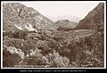
Thistle around 1871
-
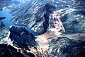
Aerial photo of the Thistle area in spring 1983 showing the dam formed by the landslide, "Lake Thistle" over the submerged town, and the construction to re-route US-6, US-89, and the D&RGW around the landslide area
-
A view from the California Zephyr, after the slide, showing the dam formed by the landslide and the scar from where the dirt slid, August 2003
-
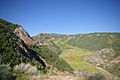
Looking northwest from the view area along US-6/US-89 showing the abandoned railroad and highway grades next to the replacement alignments, June 2010
-
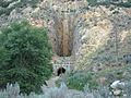
The intake for the tunnel which rerouted the Spanish Fork River past the dam formed by the Thistle landslide, July 2015
-
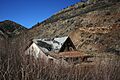
One of the few houses at Thistle to survive the landslide, April 2008
-
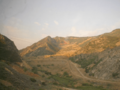
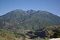
The Thistle landslide, as seen from a view area along US-6/US-89, June 2010
-
East end of Union Pacific Railroad's tunnels that bypassed the landslide in Thistle with a Late Amtrak going East, July 2024
-
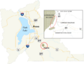
Map of Utah County showing the pre- and post-landslide alignments of US-6, US-89, and the area railroads

See also
 In Spanish: Thistle para niños
