Thomas County, Nebraska facts for kids
Quick facts for kids
Thomas County
|
|
|---|---|

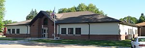
Thomas County courthouse in Thedford
|
|

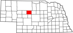
Location within the U.S. state of Nebraska
|
|
 Nebraska's location within the U.S. |
|
| Country | |
| State | |
| Founded | 1887 |
| Named for | George Henry Thomas |
| Seat | Thedford |
| Largest village | Thedford |
| Area | |
| • Total | 714 sq mi (1,850 km2) |
| • Land | 713 sq mi (1,850 km2) |
| • Water | 0.8 sq mi (2 km2) 0.1%% |
| Population
(2020)
|
|
| • Total | 669 |
| • Density | 0.9370/sq mi (0.3618/km2) |
| Time zone | UTC−6 (Central) |
| • Summer (DST) | UTC−5 (CDT) |
| Congressional district | 3rd |
Thomas County is a county in the state of Nebraska, USA. It is like a large district or area within the state. In 2020, about 669 people lived here. The main town, or county seat, is Thedford. This is where the county government offices are located. Thomas County was created in 1887. It was named after a brave general named George H. Thomas.
In Nebraska, each county has a special number on its vehicle license plates. Thomas County is represented by the number 89. This number was given in 1922. It was based on how many vehicles were registered in the county at that time.
Contents
Geography
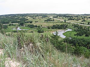
The land in Thomas County has gentle, rolling hills. These hills slope down towards the east. Two important rivers flow through the county. The Middle Loup River flows through the middle. The Dismal River flows through the lower part. Both rivers flow east-southeast. They meet each other just east of Thomas County. The county covers about 714 square miles. Most of this area, 713 square miles, is land. Only a small part, 0.8 square miles, is water.
Major Highways
 U.S. Highway 83
 Nebraska Highway 2
Neighboring Counties
- Cherry County - to the north
- Blaine County - to the east
- Logan County - to the south
- McPherson County - to the southwest
- Hooker County - to the west
Protected Areas
- Nebraska National Forest (a part of it is in Thomas County)
Population Information
| Historical population | |||
|---|---|---|---|
| Census | Pop. | %± | |
| 1890 | 517 | — | |
| 1900 | 628 | 21.5% | |
| 1910 | 1,191 | 89.6% | |
| 1920 | 1,773 | 48.9% | |
| 1930 | 1,510 | −14.8% | |
| 1940 | 1,553 | 2.8% | |
| 1950 | 1,206 | −22.3% | |
| 1960 | 1,078 | −10.6% | |
| 1970 | 954 | −11.5% | |
| 1980 | 973 | 2.0% | |
| 1990 | 851 | −12.5% | |
| 2000 | 729 | −14.3% | |
| 2010 | 647 | −11.2% | |
| 2020 | 669 | 3.4% | |
| 2022 (est.) | 671 | 3.7% | |
| US Decennial Census 1790-1960 1900-1990 1990-2000 2010 2020 2022 |
|||
The population of Thomas County has changed over the years. In 1890, there were 517 people. The population grew to 1,773 by 1920. Since then, it has slowly decreased. In 2020, the population was 669 people.
In 2000, there were 729 people living in the county. Most people were White. A very small number were Native American or from two or more races. Some people were also of Hispanic or Latino background.
There were 325 households in 2000. About 27% of these households had children under 18 living with them. Most households were married couples living together. Some households had a single female parent. About 31% of households were made up of people living alone. Many of these were people aged 65 or older.
The average age of people in the county in 2000 was 44 years old. About 24% of the population was under 18. About 20% of the population was 65 years or older.
Communities
Villages
Census-designated place
Unincorporated places
See also
 In Spanish: Condado de Thomas (Nebraska) para niños
 | Toni Morrison |
 | Barack Obama |
 | Martin Luther King Jr. |
 | Ralph Bunche |


