
Tiverton, Rhode Island facts for kids
Quick facts for kids
Tiverton, Rhode Island
|
|
|---|---|

Nanaquaket Pond, Tiverton, RI
|
|

Location of Tiverton in Newport County, Rhode Island
|
|
| Country | United States |
| State | Rhode Island |
| County | Newport |
| Settled | 1659 |
| Incorporated (Massachusetts) | June 14, 1694 |
| Annexed by Rhode Island | January 27, 1747 |
| Area | |
| • Total | 36.3 sq mi (94.1 km2) |
| • Land | 29.4 sq mi (76.0 km2) |
| • Water | 7.0 sq mi (18.0 km2) |
| Elevation | 167 ft (51 m) |
| Population
(2020)
|
|
| • Total | 16,359 |
| • Density | 558/sq mi (215.3/km2) |
| Time zone | UTC−5 (Eastern (EST)) |
| • Summer (DST) | UTC−4 (EDT) |
| ZIP Code |
02878
|
| Area code(s) | 401 |
| FIPS code | 44-70880 |
| GNIS feature ID | 1220066 |
Tiverton is a town in Newport County, Rhode Island, United States. It is a part of New England. In 2020, about 16,359 people lived there.
Contents
What is Tiverton's Location?
Tiverton is on the eastern side of Narragansett Bay. It sits across the Sakonnet River from Aquidneck Island. This island is also known as the Island of Rhode Island.
Tiverton and the nearby town of Little Compton are separated from the rest of Rhode Island. The northern part of Tiverton is on Mount Hope Bay.
Much of the town is built on a granite ridge. This ridge runs north to south. It rises about 170 feet (52 meters) above the bay. You can see a large section of this granite along Route 24.
The United States Census Bureau says Tiverton covers about 36.3 square miles (94.1 km²). About 29.4 square miles (76.0 km²) is land. The remaining 7.0 square miles (18.0 km²) is water.
The northern part of Tiverton is also called North Tiverton. Some people think Tiverton is part of the "South Coast" region of Massachusetts. This is because it shares many things with towns like Westport and Fall River.
A Look into Tiverton's Past
How Tiverton Was Formed
English colonists officially created Tiverton in 1694. It was part of Bristol County in the Province of Massachusetts Bay.
In 1746, there was a big argument about the border between Rhode Island and Massachusetts. Tiverton, along with other towns, became part of Rhode Island. This happened because of a special order from the King. Tiverton officially became a town in Rhode Island in 1747.
Before 1747, Tiverton also included an area called East Freetown. After the border change, East Freetown became part of Massachusetts.
Tiverton During the Revolutionary War

During the American Revolutionary War, men from Tiverton fought in the Battle of Freetown in 1778. Later that year, about 150 British soldiers attacked Tiverton. The British thought the American militia was planning an attack.
However, the American militia was ready in their defense spots. Two British soldiers were killed, and several were hurt. Some damage was done to a mill in Tiverton. No American militiamen were hurt or killed.
For about three years during the war, the British took over Aquidneck Island. Tiverton became a safe place for Americans escaping the British. It was also a gathering spot for American soldiers. The British eventually left the island to fight elsewhere.
Tiverton's Early Industries
In its early days, Tiverton was mostly a farming town. People also fished and built boats. Until 1900, making menhaden oil from fish was a main industry.
Cotton and wool factories started as early as 1811. Colonel Joseph Durfee built a spinning mill in what is now Fall River, Massachusetts.
In 1856, the northern part of Tiverton became a separate town called Fall River, Rhode Island. But in 1862, the United States Supreme Court decided that both Fall Rivers should be part of Massachusetts. The state border was then set where it is today.
Mark's Stadium was a soccer stadium in North Tiverton, Rhode Island. In the 1920s and early 1930s, it was home to the Fall River F.C. This was one of the best soccer teams at the time. It was one of the first stadiums built just for soccer in the United States.
Recent Events in Tiverton
In 1997, a weather station was set up in Tiverton. It records official weather data for the town. This information is collected by the National Weather Service and other centers.
Since the mid-1900s, Tiverton has become a popular summer spot. It is also a place where people live and commute to Fall River, Massachusetts. In the 1960s, Route 24 was built. This road connects Tiverton to Newport, Rhode Island using the Sakonnet River Bridge.
In 2002, some soil in the Bay Street neighborhood was found to be contaminated. This means it had harmful substances in it. Tests in 2003 found things like arsenic, lead, and cyanide. These were at levels higher than safe for homes. Residents were told not to dig in their soil.
A group called ENACT (Environmental Neighborhood Awareness Committee of Tiverton) helps the community. Property values in the area have dropped because of the contamination. ENACT helped pass a law to create a loan program for people whose home values were affected. The Rhode Island Department of Environmental Management is working to clean up the contamination.
In 2018, the Tiverton Casino Hotel opened. It is now called Bally's Tiverton.
Tiverton's Beaches
Tiverton has two main beaches: Fogland Beach and Grinnell's Beach. Both are located on the Sakonnet River. Cool breezes blow there all year.
Fogland Beach has lifeguards for safety. You can also fish, walk, and watch wildlife there. It's a great place for windsurfing and kite-surfing. You can even rent equipment and take lessons.
Grinnell's Beach is also excellent for windsurfing. It offers a nice view of the Sakonnet River. The beach has changing rooms, showers, and shaded seating areas.
What is Tiverton's Climate Like?
| Climate data for Tiverton, Rhode Island (1991–2020 normals, extremes 1998–present | |||||||||||||
|---|---|---|---|---|---|---|---|---|---|---|---|---|---|
| Month | Jan | Feb | Mar | Apr | May | Jun | Jul | Aug | Sep | Oct | Nov | Dec | Year |
| Record high °F (°C) | 63 (17) |
66 (19) |
75 (24) |
90 (32) |
96 (36) |
100 (38) |
103 (39) |
101 (38) |
96 (36) |
84 (29) |
74 (23) |
71 (22) |
103 (39) |
| Mean daily maximum °F (°C) | 38.5 (3.6) |
41.3 (5.2) |
49.0 (9.4) |
60.0 (15.6) |
70.1 (21.2) |
79.3 (26.3) |
84.9 (29.4) |
84.0 (28.9) |
76.9 (24.9) |
64.3 (17.9) |
52.7 (11.5) |
43.3 (6.3) |
62.0 (16.7) |
| Daily mean °F (°C) | 31.0 (−0.6) |
32.9 (0.5) |
39.7 (4.3) |
49.6 (9.8) |
59.6 (15.3) |
68.8 (20.4) |
74.9 (23.8) |
74.0 (23.3) |
67.1 (19.5) |
55.4 (13.0) |
44.8 (7.1) |
36.4 (2.4) |
52.8 (11.6) |
| Mean daily minimum °F (°C) | 23.6 (−4.7) |
24.5 (−4.2) |
30.3 (−0.9) |
39.3 (4.1) |
49.0 (9.4) |
58.4 (14.7) |
65.0 (18.3) |
64.0 (17.8) |
57.3 (14.1) |
46.6 (8.1) |
37.0 (2.8) |
29.5 (−1.4) |
43.7 (6.5) |
| Record low °F (°C) | −5 (−21) |
−7 (−22) |
7 (−14) |
20 (−7) |
33 (1) |
40 (4) |
51 (11) |
51 (11) |
38 (3) |
29 (−2) |
13 (−11) |
5 (−15) |
−7 (−22) |
| Average precipitation inches (mm) | 4.01 (102) |
3.84 (98) |
5.55 (141) |
4.50 (114) |
3.57 (91) |
3.66 (93) |
2.96 (75) |
3.81 (97) |
3.93 (100) |
4.54 (115) |
4.11 (104) |
4.91 (125) |
49.39 (1,255) |
| Average snowfall inches (cm) | 10.9 (28) |
11.3 (29) |
7.4 (19) |
0.6 (1.5) |
0.0 (0.0) |
0.0 (0.0) |
0.0 (0.0) |
0.0 (0.0) |
0.0 (0.0) |
0.0 (0.0) |
0.6 (1.5) |
7.3 (19) |
38.1 (97) |
| Average precipitation days (≥ 0.01 in) | 12.3 | 11.4 | 11.7 | 13.1 | 13.1 | 11.5 | 9.8 | 9.1 | 9.4 | 11.7 | 9.9 | 12.6 | 135.6 |
| Average snowy days (≥ 0.1 in) | 5.2 | 5.2 | 3.3 | 0.4 | 0.0 | 0.0 | 0.0 | 0.0 | 0.0 | 0.0 | 0.4 | 3.4 | 17.9 |
| Source: NOAA | |||||||||||||
Tiverton has a climate with warm summers and cold winters. The hottest month is usually July, with average temperatures around 74.9°F (23.8°C). The coldest month is January, with an average of 31.0°F (-0.6°C).
The town gets a good amount of rain throughout the year. Snowfall is common in winter, especially in January and February.
Who Lives in Tiverton?
| Historical population | |||
|---|---|---|---|
| Census | Pop. | %± | |
| 1790 | 2,453 | — | |
| 1800 | 2,717 | 10.8% | |
| 1810 | 2,837 | 4.4% | |
| 1820 | 2,875 | 1.3% | |
| 1830 | 2,905 | 1.0% | |
| 1840 | 3,183 | 9.6% | |
| 1850 | 4,699 | 47.6% | |
| 1860 | 1,927 | −59.0% | |
| 1870 | 1,808 | −6.2% | |
| 1880 | 2,505 | 38.6% | |
| 1890 | 2,837 | 13.3% | |
| 1900 | 2,977 | 4.9% | |
| 1910 | 4,032 | 35.4% | |
| 1920 | 3,894 | −3.4% | |
| 1930 | 4,578 | 17.6% | |
| 1940 | 5,018 | 9.6% | |
| 1950 | 5,659 | 12.8% | |
| 1960 | 9,461 | 67.2% | |
| 1970 | 12,559 | 32.7% | |
| 1980 | 13,526 | 7.7% | |
| 1990 | 14,312 | 5.8% | |
| 2000 | 15,260 | 6.6% | |
| 2010 | 15,780 | 3.4% | |
| 2020 | 16,359 | 3.7% | |
| U.S. Decennial Census | |||
In 2000, there were 15,260 people living in Tiverton. They lived in 6,077 households. Most people (97.98%) were White.
About 29.6% of households had children under 18. Most households (60.2%) were married couples. The average household had 2.51 people.
The average age of people in Tiverton was 41 years old. For every 100 females, there were about 95 males.
The median income for a household was $49,977. For families, it was $58,917. A small number of families (2.9%) and people (4.5%) lived below the poverty line.
Historic Places to Visit
Tiverton has several places listed on the National Register of Historic Places. These are important sites that tell about the town's history.
- Bourne Mill
- Cook-Bateman Farm
- First Baptist Church of Tiverton
- Fort Barton Site
- Osborn-Bennett Historic District
- Tiverton Four Corners Historic District
Famous People from Tiverton
- Robert Gray: A sea-captain and explorer.
- Russell Warren (1783–1860): A famous architect.
Schools in Tiverton
Tiverton has five public schools for its students:
- Pocasset Elementary School
- Fort Barton Elementary School
- Ranger Elementary School (recently rebuilt)
- Tiverton Middle School
- Tiverton High School
The town has its own school district. It is also part of the larger Newport County district.
Tiverton Public Library
_Public_Library.jpg)

The Tiverton Public Library started in 1927. Over the years, it moved to different places in town.
In June 2015, a new library building opened. It is 24,000 square feet (about 2,230 square meters). It has a meeting hall, a teen room, a cafe, and a children's library. The building also has outdoor courtyard spaces. The new library won an award for its design in 2018.
There is also a branch library called the Union Public Library. It is located at 3832 Main Road. This branch has been open almost continuously since 1820. The building you see today was built in 1868. Volunteers help staff provide reading and library services there.
Images for kids
-
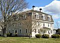
The main house of the Cook-Bateman Farm
-
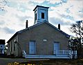
The First Baptist Church, known as the "Old Stone Church"
-
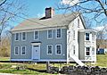
The Thomas Bennett Homestead in the Osborn-Bennett Historic District
-
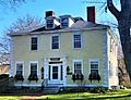
The Soule-Seabury Mansion in the Tiverton Four Corners Historic District


See also
 In Spanish: Tiverton (Rhode Island) para niños
