Treaty of Fort Laramie (1851) facts for kids
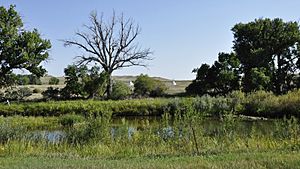
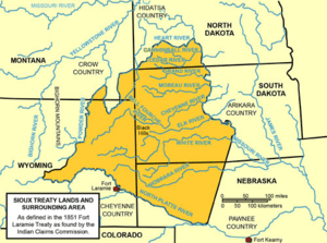
The Fort Laramie Treaty of 1851 was an important agreement. It was signed on September 17, 1851. The United States government and several Native American nations made this treaty. These nations included the Cheyenne, Sioux, Arapaho, Crow, Assiniboine, Mandan, Hidatsa, and Arikara. This treaty is also known as the Horse Creek Treaty. It aimed to define the traditional lands of each tribe.
The United States agreed that all the land in the treaty belonged to Native Americans. They did not claim any part of it for themselves. The borders set by this treaty were used later in the 1900s to settle land claims. In return, the Native American tribes promised safe travel for settlers. These settlers were using the Oregon Trail. The tribes also allowed roads and forts to be built on their lands. For this, the U.S. government promised to pay them $50,000 each year. This payment was supposed to last for 50 years. The treaty also aimed to create a lasting peace among the eight tribes. These tribes often had conflicts with each other.
Why the Treaty Was Needed
Many people from Europe and America traveled west. They used trails like the Oregon Trail and Santa Fe Trail. But the California Gold Rush started in 1848. This caused many more people to travel through the Great Plains. This increased traffic led to worries about conflict.
In 1849, government officials suggested a meeting with the Native American tribes. They wanted to prevent fights. The U.S. government wanted to protect the travelers' path. They met with the Plains Indians living between the Arkansas River and Missouri River. Congress approved $100,000 for this meeting.
The area around Fort Laramie did not have enough food for the horses. So, the treaty meeting happened about 30 miles downriver. It was held at the mouth of Horse Creek. This is why many Native Americans called it the Horse Creek Treaty. Many tribal leaders attended. These included leaders from the Lakota Sioux, Cheyenne, Assiniboine, Gros Ventre, Mandan, Arikara, Hidatsa, Shoshone, Crow, and Arapaho.
The United States Senate approved the treaty. But they made one change. They changed the payment period from 50 years to 10 years. All tribes except the Crow accepted this change. Sadly, some tribes never received the promised payments.
Lands of the Treaty
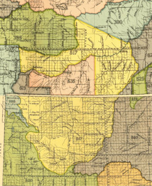
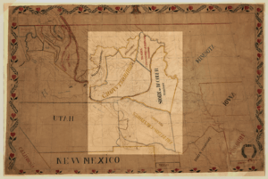
The treaty set specific land areas for each tribe. This caused some disagreements.
The Lakota Sioux were given special rights to the Black Hills. This area is in present-day South Dakota. But the Cheyenne and Arapaho also claimed these lands. A Cheyenne historian said in 1967, "the Sioux were given rights to the Black Hills... Their home country was the Black Hills." In 1875, Arapaho chief Black Coal complained. He said, "I have never got anything yet for my land [the Black Hills]. It is part mine, and part the Sioux."
The Cheyenne and Arapaho tribes lived south of the North Platte River. This area is mostly in present-day Wyoming and Colorado. They shared this land.
The Crow tribe's land was in present-day Montana and Wyoming. It stretched west from the Powder River. The Little Bighorn River flowed through the middle of their territory.
What Happened After the Treaty
The treaty was broken very soon after it was signed. In 1858, many miners and settlers moved into Colorado. This was during the Pike's Peak Gold Rush. The United States government did not stop them. These newcomers took over Native American lands for mining. They built towns and farms. They also improved roads.
By 1861, the Cheyenne and Arapaho had been pushed out of the mountain regions. They were forced towards the Arkansas River. These new settlers competed with the tribes for hunting game and water. This caused problems and conflicts. The U.S. government did not make sure the treaty was followed. In 1864, the Sand Creek massacre happened. U.S. soldiers attacked a camp of mostly Cheyenne people. This led to many years of war.
Another event was the Grattan affair in 1854. U.S. soldiers entered a Sioux camp without permission. They wanted to arrest people accused of stealing a cow. This led to a battle where Chief Conquering Bear was killed.
Native American tribes had fought among themselves before. But new problems made things worse. White settlers and government agents killed huge numbers of bison. The U.S. Army did not stop these hunters. Sometimes, they even protected them or gave them ammunition. Hundreds of thousands of bison were killed each year. This pushed them close to extinction. Bison were a main food source for the tribes. With fewer bison, tribes had to hunt in each other's areas. This led to more fighting.
By summer 1862, all three tribes were forced from their shared treaty land. "We, the Arikara, have been driven from our country... by the Sioux," said Chief White Shield in 1864. The loss of bison also made the Yanktonai Sioux move into Assiniboine hunting grounds.
Soon, the Crow's western Powder River area was filled with Lakota people. They were looking for bison. Large battles happened near present-day Wyola, Montana. The Crow tribe was slowly pushed out. "The country from the Powder River to the Yellowstone River was their country... until 1859, when they were driven from it by the Sioux." In 1868, the Lakotas took over part of the Crow's 1851 land.
Over time, large parts of these Native American lands became U.S. property. Smaller parts of the original lands became separate reservations. These were usually for the tribes who had treaty rights in 1851.
However, the Crow territory ended up providing land for two reservations. The Crow Reservation was created in 1868. It was in the center of their original territory. The reservation for the Northern Cheyenne was created in 1884. It is entirely within the 1851 Crow territory.
The Northern Arapaho settled on the reservation of their former enemies, the Shoshone. This is the Wind River Indian Reservation in Wyoming. The Southern Cheyenne and Arapaho live on a shared reservation in Oklahoma. This is also far from their 1851 treaty land.
The Assiniboine in the United States have lived on the Fort Peck Indian Reservation and Fort Belknap Indian Reservation since 1888. Both are north of the Missouri River in Montana. The Assiniboine's treaty land south of the Missouri was only a small part of their large hunting area.
See also
 In Spanish: Tratado del fuerte Laramie (1851) para niños
 | Chris Smalls |
 | Fred Hampton |
 | Ralph Abernathy |


