
Truyère facts for kids
Quick facts for kids Truyère |
|
| River | |
 The Truyère in Entraygues-sur-Truyère
|
|
| Country | France |
|---|---|
| Regions | Occitanie, Auvergne-Rhône-Alpes |
| Departments | Lozère, Cantal, Aveyron |
| Commune | Entraygues-sur-Truyère |
| Tributaries | |
| - left | Bès, Selves |
| - right | Goul |
| City | Entraygues-sur-Truyère |
| Source | Massif Central |
| - location | La Villedieu, Lozère, France |
| - elevation | 1,460 m (4,790 ft) |
| - coordinates | 44°43′38″N 3°33′43″E / 44.72722°N 3.56194°E |
| Mouth | Lot |
| - location | Entraygues-sur-Truyère, Aveyron, France |
| - elevation | 228 m (748 ft) |
| - coordinates | 44°38′37″N 2°33′45″E / 44.64361°N 2.56250°E |
| Length | 167.2 km (104 mi) |
| Basin | 5,507 km² (2,126 sq mi) |
| Discharge | for Entraygues-sur-Truyèret |
| - average | 69.5 m³/s (2,454 cu ft/s) |
The Truyère (pronounced "Truy-air") is an important river in southwestern France. It is the main river that flows into the larger Lot river.
Contents
About the Truyère River
The Truyère river is about 167.2 km (103.9 mi) long. The area of land that drains into the river, called its drainage basin, is about 5,507 km2 (2,126 sq mi).
Every year, the river carries a lot of water. On average, about 69.5 cubic metres of water flow past a certain point near Entraygues-sur-Truyèret every second. This measurement is called the river's discharge.
Where the River Starts and Flows
The Truyère river begins high up in the Margeride mountains. These mountains are part of the south-western Massif Central in France. The river starts near the town of La Villedieu in the Lozère department. It begins at a high point, about 1,460 m (4,790 ft) above sea level.
Generally, the Truyère river flows towards the west. As it travels, it goes through two large areas of France called regions. It also passes through three smaller areas called departments. The river flows through 44 different towns or villages, known as communes.
- The first region it enters is Occitanie:
- In the Lozère department, it flows through towns like Le Malzieu-Ville, Chaulhac, Saint-Léger-du-Malzieu, Rimeize, Blavignac, Saint-Pierre-le-Vieux, Fontans, Saint-Gal, and Serverette.
- Next, it goes into the Auvergne-Rhône-Alpes region:
- Here, in the Cantal department, it passes through places such as Saint-Martial, Chaliers, Oradour, Fridefont, Alleuze, Faverolles, and Neuvéglise.
- Finally, it returns to the Occitanie region:
- In the Aveyron department, it flows past towns like Entraygues-sur-Truyère, Thérondels, Cantoin, Montézic, and Brommat.
The Truyère river eventually joins the Lot river. It flows into the Lot river from the right side, near the town of Entraygues-sur-Truyèret in the Aveyron department. At this point, the river is about 228 m (748 ft) above sea level.
A famous structure called the Garabit viaduct crosses the Truyère river. This large bridge was built by Gustave Eiffel, who also designed the Eiffel Tower. It is located near Ruynes-en-Margeride.
There are also several dams built along the Truyère river. These dams are used to create hydroelectricity, which is electricity made from the power of flowing water.
Main Rivers Joining the Truyère
Many smaller rivers and streams flow into the Truyère river. These are called tributaries. Here are some of the most important ones:
|
Rivers joining from the left:
|
Rivers joining from the right:
|
Gallery
-
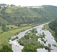
The Truyère river seen from Chaliers
-
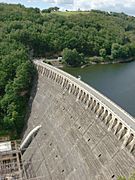
The Sarrans dam on the Truyère river
-
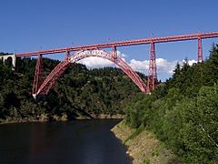
The impressive Garabit viaduct crossing the Truyère


Related pages
Images for kids
-
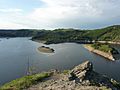
The Truyère river at Lac de Grandval

See also
 In Spanish: Río Truyère para niños
