
Turmequé facts for kids
Quick facts for kids
Turmequé
|
||
|---|---|---|
|
Municipality and town
|
||

Catholic church and central square
|
||
|
||

Location of the municipality and town of Turmequé in the Boyacá Department of Colombia
|
||
| Country | ||
| Department | Boyacá Department | |
| Province | Márquez Province | |
| Founded | 20 July 1537 | |
| Founded by | Gonzalo Jiménez de Quesada | |
| Area | ||
| • Municipality and town | 106 km2 (41 sq mi) | |
| • Urban | 4 km2 (2 sq mi) | |
| Elevation | 2,389 m (7,838 ft) | |
| Population | ||
| • Municipality and town | 6,182 | |
| • Density | 58.32/km2 (151.1/sq mi) | |
| • Urban | 2,565 | |
| Time zone | UTC-5 (Colombia Standard Time) | |
| Website | Official website: http://www.turmeque-boyaca.gov.co/ | |
.svg)
Turmequé is a town and a municipality (a type of local government area) in Colombia. It is located in the Boyacá Department, which is like a state or province. Turmequé is part of the Márquez Province within Boyacá.
This town is about 105 kilometers (65 miles) northeast of Bogotá, the capital city of Colombia. Turmequé shares its borders with other towns. To the west is Ventaquemada, to the east is Úmbita, to the north is Nuevo Colón, and to the south is Villapinzón in the Cundinamarca region.
Contents
History of Turmequé
Ancient Muisca History
Before the Spanish arrived, Turmequé was a very important place for the Muisca. The Muisca were an ancient group of people who lived in the Altiplano Cundiboyacense, a high plateau region in Colombia.
The Muisca had a large group of communities called the Muisca Confederation. Turmequé was part of this confederation, which was led by a powerful ruler called the zaque. The zaque's main city was Hunza, which is now the city of Tunja.
Spanish Arrival and Founding
The Spanish arrived in the area during their search for a legendary golden city called El Dorado. The Spanish conquest was led by Gonzalo Jiménez de Quesada. He officially founded modern Turmequé on July 20, 1537.
The name "Turmequé" comes from the Chibcha language, which was spoken by the Muisca. It means "vigorous chief." Another old name for the town is Valle de las trompetas, meaning "Trumpet Valley." This name came from the trumpets that the Spanish conquistadores (conquerors) carried with them.
Birthplace of Tejo
Turmequé is famous for being the birthplace of tejo. Tejo is the national sport of Colombia! It was originally called Turmequé. In the center of the town, there is a statue honoring Chaquén, who was the Muisca god of sports. This statue reminds everyone of the town's connection to tejo.
Changes in Town Borders
Over time, the size of Turmequé changed. In 1773, the area known as Villapinzón (which was then called Hato Viejo) became its own separate town. A few years later, in 1776, Ventaquemada also separated from Turmequé to become its own municipality.
Economy of Turmequé
Town Center Activities
The main part of Turmequé, the town center, is mostly focused on business. People here work in commerce (buying and selling goods) and provide different services to the community.
Rural Agriculture
Outside the town center, the rural areas are mainly used for agriculture. Farmers grow many different crops. These include common vegetables like potatoes, beans, maize (corn), onions, and peas. They also grow grains such as wheat and barley.
Fruits and Livestock
Turmequé also produces various fruits. You can find prunes, blackberries, pears, and apples. The town also grows special Colombian fruits like curuba and feijoa. When it comes to livestock (farm animals), the main type of farming is raising pork.
Tourism in Turmequé
Tejo Championships
Turmequé attracts many visitors because it is the birthplace of tejo. Every year, the national championships for tejo are held right here in Turmequé. This event brings players and fans from all over the country.
Religious Museum
Besides sports, the town also has a religious museum. This museum displays items related to the local religious history and traditions, offering another interesting place for tourists to visit.
Climate in Turmequé
Turmequé has a mild climate due to its elevation. The weather here is generally cool and comfortable throughout the year.
| Climate data for Turmequé/Nuevo Colón, elevation 2,438 m (7,999 ft), (1981–2010) | |||||||||||||
|---|---|---|---|---|---|---|---|---|---|---|---|---|---|
| Month | Jan | Feb | Mar | Apr | May | Jun | Jul | Aug | Sep | Oct | Nov | Dec | Year |
| Mean daily maximum °C (°F) | 21.9 (71.4) |
22.1 (71.8) |
21.8 (71.2) |
20.6 (69.1) |
19.7 (67.5) |
18.0 (64.4) |
17.2 (63.0) |
17.5 (63.5) |
18.8 (65.8) |
19.8 (67.6) |
20.5 (68.9) |
20.9 (69.6) |
19.9 (67.8) |
| Daily mean °C (°F) | 14.7 (58.5) |
14.8 (58.6) |
15.1 (59.2) |
15.0 (59.0) |
14.6 (58.3) |
13.9 (57.0) |
13.3 (55.9) |
13.4 (56.1) |
13.9 (57.0) |
14.4 (57.9) |
14.7 (58.5) |
14.6 (58.3) |
14.4 (57.9) |
| Mean daily minimum °C (°F) | 9.1 (48.4) |
9.7 (49.5) |
10.3 (50.5) |
10.9 (51.6) |
11.0 (51.8) |
10.5 (50.9) |
10.0 (50.0) |
9.9 (49.8) |
9.5 (49.1) |
10.0 (50.0) |
10.3 (50.5) |
9.6 (49.3) |
10.1 (50.2) |
| Average precipitation mm (inches) | 16.1 (0.63) |
28.6 (1.13) |
54.1 (2.13) |
84.0 (3.31) |
108.7 (4.28) |
115.3 (4.54) |
124.3 (4.89) |
102.8 (4.05) |
76.1 (3.00) |
96.3 (3.79) |
71.6 (2.82) |
31.0 (1.22) |
908.7 (35.78) |
| Average precipitation days (≥ 1.0 mm) | 6 | 9 | 12 | 18 | 24 | 24 | 26 | 25 | 20 | 20 | 17 | 10 | 208 |
| Average relative humidity (%) | 79 | 79 | 79 | 82 | 85 | 87 | 88 | 88 | 85 | 84 | 83 | 81 | 83 |
| Mean monthly sunshine hours | 195.3 | 158.1 | 151.9 | 111.0 | 105.4 | 87.0 | 89.9 | 99.2 | 126.0 | 136.4 | 150.0 | 186.0 | 1,596.2 |
| Mean daily sunshine hours | 6.3 | 5.6 | 4.9 | 3.7 | 3.4 | 2.9 | 2.9 | 3.2 | 4.2 | 4.4 | 5.0 | 6.0 | 4.4 |
| Source: Instituto de Hidrologia Meteorologia y Estudios Ambientales | |||||||||||||
Gallery
-
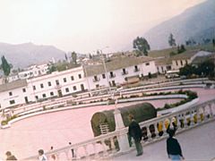
Central square
-
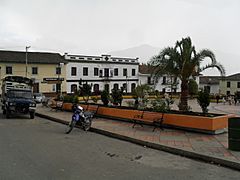
Square
-
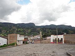
Street view
-
View of Turmequé
-
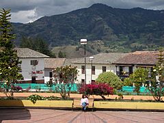
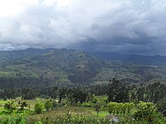
Turmequé with Cordillera Oriental in the background
..jpg)


-
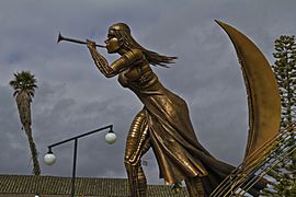
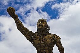
Monument honouring the indigenous Muisca
-
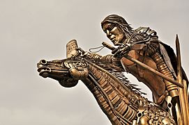
Muisca monument at the central square
-
Monument
-
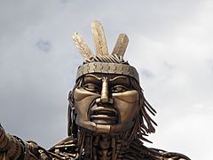
Head of the statue


.JPG)


See also
 In Spanish: Turmequé para niños
