
Turtle Creek (Susquehanna River tributary) facts for kids
Quick facts for kids Turtle Creek |
|
|---|---|

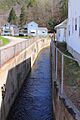
Turtle Creek looking upstream in Mocanaqua
|
|
| Physical characteristics | |
| Main source | valley near Lee Road in Conyngham Township, Luzerne County, Pennsylvania between 860 and 880 feet (260 and 270 m) |
| River mouth | Susquehanna River in Mocanaqua in Conyngham Township, Luzerne County, Pennsylvania 482 ft (147 m) 41°08′33″N 76°08′40″W / 41.14239°N 76.14447°W |
| Length | 2.5 mi (4.0 km) |
| Basin features | |
| Progression | Susquehanna River → Chesapeake Bay |
| Basin size | 1.59 sq mi (4.1 km2) |
Turtle Creek (also called Turtle Run) is a small river that flows into the Susquehanna River in Luzerne County, Pennsylvania. It's about 2.5 miles (4 kilometers) long and runs through Conyngham Township. The area of land that drains into the creek, called its watershed, is about 1.59 square miles (4.12 square kilometers). Turtle Creek is important because it's home to fish that like cold water and also helps protect against floods.
Contents
Where Turtle Creek Flows
Turtle Creek starts in a valley near Lee Road in Conyngham Township. It flows towards the west-southwest for about 1.5 miles (2.5 kilometers), following Lee Road. Along its path, it goes through a small pond or lake before reaching the town of Mocanaqua.
Once in Mocanaqua, the creek keeps flowing west-southwest for a short distance. Then, it turns towards the northwest. After a little while, it turns west-southwest again. Finally, after flowing a bit further, it joins the Susquehanna River. Turtle Creek meets the Susquehanna River about 171.70 miles (276.32 kilometers) upstream from the Susquehanna's mouth.
Water Flow in Turtle Creek
Turtle Creek is a perennial stream, which means it flows all year round and does not dry up.
Land and Rocks Around the Creek
The land around the mouth of Turtle Creek is about 482 feet (147 meters) above sea level. Where the creek begins, its source, the land is higher, between 860 and 880 feet (262 and 268 meters) above sea level.
Near the start of Turtle Creek, the ground is mostly made of solid bedrock like sandstone and shale. You might also find some areas with "Wisconsinan Bouldery Till." This is a type of soil left behind by glaciers, and it has many large boulders in it. To the north of the creek's valley, there are large areas where strip mining has taken place.
Closer to where the creek meets the Susquehanna River, the ground mainly has Wisconsinan Bouldery Till and "Wisconsinan Ice-Contact Stratified Drift." This drift contains layers of sand and gravel, along with some boulders. Other materials found near the creek's mouth include "Wisconsinan Outwash" (materials washed out by melting glaciers), alluvium (river deposits), alluvial terraces (old riverbeds), fill (materials used to raise land), and coal dumps (large piles of coal waste).
The valley where Turtle Creek flows is deep and narrow. A bridge on Paradise Avenue crosses Turtle Creek in Conyngham Township. In 1997, plans were made to replace this bridge with a new structure.
Turtle Creek's Drainage Area
The area of land that drains water into Turtle Creek, known as its watershed, covers about 1.59 square miles (4.12 square kilometers). The mouth of the creek is located in the Shickshinny area, according to the United States Geological Survey maps. However, the creek's source is in the Nanticoke area. This entire drainage basin is part of the larger Lower North Branch Susquehanna drainage basin.
History of Turtle Creek
Turtle Creek was officially added to the Geographic Names Information System on August 2, 1979. Its official identification number there is 1189974. The creek is also known by the name "Turtle Run," which appeared on a map called Patton's Philadelphia and Suburbs Street and Road Map in 1984.
The Pennsylvania Department of Environmental Protection has completed a flood protection project along Turtle Creek. This project helps to prevent the creek from overflowing its banks and causing damage. Ideas for such a project were first considered as early as 1957.
Wildlife in Turtle Creek
The entire area that drains into Turtle Creek is special because it's designated as a Coldwater Fishery and a Migratory Fishery. This means the creek's waters are cold enough for certain types of fish to live there, and it's also a place where fish travel during their migration.
Images for kids
-
Turtle Creek looking upstream in Mocanaqua
