
U.S. Route 36 facts for kids
Quick facts for kids
|
|
|---|---|
 |
|
| Route information | |
| Length | 1,414 mi (2,276 km) |
| Existed | 1926–present |
| Major junctions | |
| West end | |
|
|
| East end | |
| Location | |
| States: | Colorado, Kansas, Missouri, Illinois, Indiana, Ohio |
| Highway system | |
| United States Numbered Highways List • Bannered • Divided • Replaced |
|

U.S. Route 36 (or US 36) is a very long road in the United States. It travels from west to east across the country. This highway is about 1,414 miles (2,276 kilometers) long.
It starts in the west at Rocky Mountain National Park in Colorado. Here, it meets US 34 at a place called Deer Ridge Junction. The eastern end of US 36 is in Uhrichsville, Ohio. There, it connects with US 250.
Contents
Traveling Along US 36
US 36 is a major road that crosses six different states. It connects many towns and cities along its path. This highway is part of the U.S. Highway System. This system helps people travel easily across the country.
States US 36 Crosses
US 36 starts in the beautiful mountains of Colorado. Then it goes through the flat lands of Kansas. After that, it enters Missouri, a state known for its rivers.
Next, it crosses Illinois, which has lots of farmland. It continues into Indiana, a state with many big cities. Finally, US 36 ends its journey in Ohio.
Important Connections
As US 36 travels across the country, it connects with many other important roads. These include major interstate highways. For example, in Colorado, it meets I-25 and I-70 near Denver.
In Missouri, it crosses I-29 in St. Joseph. It also meets I-35 in Cameron. Near Hannibal, it connects with I-72.
Further east, in Illinois, US 36 crosses I-55 in Springfield. It also meets I-57 in Tuscola.
When it reaches Indiana, US 36 connects with several interstates in Indianapolis. These include I-65, I-70, and I-74.
Finally, in Ohio, it crosses I-75 in Piqua. It also meets I-71 west of Sunbury. These connections make US 36 a very useful road for long trips.
History of US 36
US 36 was officially created in 1926. This was part of a big plan to number and organize roads across the United States. Before this, many roads had different names in different places. The new system made it much easier for people to find their way.
The highway has been an important route for travel and trade for nearly a century. It helps people and goods move between the western and eastern parts of the country.
Images for kids
-
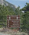
Sign on US 34 approaching the western endpoint of US 36 at Deer Ridge Junction in Rocky Mountain National Park.
-

US 36 crossing the Missouri River on the Pony Express Bridge in St. Joseph. I-229 parallels the river.

