
Upper Marlboro, Maryland facts for kids
Quick facts for kids
Upper Marlboro, Maryland
|
|||
|---|---|---|---|
| Town of Upper Marlboro | |||

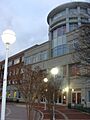
The Upper Marlboro courthouse under renovation in 2008.
|
|||
|
|||

Location of Upper Marlboro, Maryland
|
|||
| Country | |||
| State | |||
| County | Prince George's | ||
| Settled | 1695 | ||
| Established | 1706 (as Marlborough Town) | ||
| Replatted | 1744 (as Upper Marlborough) | ||
| Incorporated | 1870 | ||
| Founded by | Kingdom of England | ||
| Named for | John Churchill, 1st Duke of Marlborough | ||
| Government | |||
| • Type | Commission | ||
| Area | |||
| • Total | 0.74 sq mi (1.91 km2) | ||
| • Land | 0.69 sq mi (1.79 km2) | ||
| • Water | 0.05 sq mi (0.12 km2) | ||
| Elevation | 23 ft (7 m) | ||
| Population
(2020)
|
|||
| • Total | 652 | ||
| • Density | 946.30/sq mi (365.17/km2) | ||
| Time zone | UTC-5 (Eastern (EST)) | ||
| • Summer (DST) | UTC-4 (EDT) | ||
| ZIP Codes |
20772, 20773, 20792
|
||
| Area codes | 301, 240 | ||
| FIPS code | 24-79875 | ||
| GNIS feature ID | 0598208 | ||


Upper Marlboro, officially called the Town of Upper Marlboro, is a small town in Maryland, USA. It is the main government center, or county seat, for Prince George's County, Maryland. In 2020, about 652 people lived within the town's official borders. However, a much larger area known as Greater Upper Marlboro has many more people.
Contents
The Name of Upper Marlboro
Upper Marlboro got its start in 1706. It was first called "Marlborough Town." The town was named after John Churchill, 1st Duke of Marlborough. He was an ancestor of the famous leader Winston Churchill.
In 1744, the name changed to "Upper Marlborough." The word "Upper" was added to tell it apart from another town called Marlboro in Calvert County. Later, in the late 1800s, the name changed again to "Upper Marlboro." This happened because a postal worker thought the letters "ugh" were hard to fit on the stamps. By 1893, the new spelling stuck, even though people tried to change it back in 1968.
History of Upper Marlboro
Early Settlement and Founding
People first settled in the Upper Marlboro area around 1695. The land that became the town was once part of large estates. These estates belonged to important families like the Brooke, Beall, and Darnall families.
One old house, Darnall's Chance, was built between 1694 and 1712. You can still find it today. This house might have been the birthplace of Daniel Carroll. He was one of the people who signed the U.S. Constitution. His brother, John Carroll, who became the first Catholic archbishop in the United States, might also have been born there.
In 1706, Marlborough Town was officially created as a port town. This meant it was a place where ships could load and unload goods. The town was planned with streets, alleys, and lots for homes and businesses.
Growth as a Port Town
At first, the Western Branch of the Patuxent River was deep enough for ships. This allowed Upper Marlboro to become a busy port for shipping tobacco. Tobacco was a very important crop in the area. The town grew into a center for farming, social life, and politics.
In 1721, a courthouse was built in the town. This made Upper Marlboro the county seat, which means it became the main government center for the county. The courthouse was paid for by a small tax on tobacco. One of the first laws made there was about setting up public schools.
Many important people, like merchants, lawyers, and politicians, lived and worked in Upper Marlboro. Horse racing also became popular in the mid-1700s. Races were held at a track south of town until 1972. Today, that area is the Prince George's Equestrian Center.
In 1870, Upper Marlboro officially became an incorporated town. This meant it had its own local government. A volunteer fire department was started in 1886.
Over time, the town changed. The land clearing for tobacco farming caused soil to wash away. This filled the river with dirt, making it too shallow for ships. The tobacco fields have mostly been replaced by homes.
Prince George's County Courthouse
The courthouse has been a key part of Upper Marlboro since 1721. It has been rebuilt and expanded many times. A new courthouse was built between 1798 and 1801. It was rebuilt again in the 1880s.
In 1939, the courthouse was greatly expanded. It gained its famous stone columns. This made it look like a grand university building.
In the early 1990s, a new, much larger courthouse was built behind the old one. The old courthouse was then connected to the new building by walkways.
In 2003, the old courthouse closed for repairs. In 2004, a fire broke out and badly damaged the building. Only a burned frame was left of its famous dome. In 2007, there was another small fire during construction, but it was quickly put out. The old courthouse finally reopened in 2009 after many years of renovations.
Future Plans for the County Seat
Since the 1990s, the county government has been buying land in Largo, Maryland. Largo is easier to reach because it's near the Washington Metro train system and major highways. In 2015, county leaders suggested moving the county seat from Upper Marlboro to Largo. They believe this would help serve residents better.
Geography and Climate
Upper Marlboro is located in Prince George's County, Maryland. This county is a large area next to Washington, D.C. Major roads like U.S. Route 301 and Maryland Route 4 meet near the town.
The town has important buildings like the courthouse, county offices, and the Board of Education. South of town is the Prince George's Equestrian Center. This center hosts the annual county fair and other events.
Even though the area around Upper Marlboro has many farms and open spaces, more and more housing developments are being built. The town itself has limited shopping. Residents often travel to nearby towns like Bowie or Waldorf for larger stores.
It's important to know that the small Town of Upper Marlboro is different from the larger area called Greater Upper Marlboro. The larger area has nearly 20,000 people.
Local Weather
Upper Marlboro has hot, humid summers. Its winters are generally mild to cool. This type of weather is called a humid subtropical climate.
Population and People
| Historical population | |||
|---|---|---|---|
| Census | Pop. | %± | |
| 1870 | 42 | — | |
| 1880 | 541 | 1,188.1% | |
| 1890 | 439 | −18.9% | |
| 1900 | 449 | 2.3% | |
| 1910 | 361 | −19.6% | |
| 1920 | 385 | 6.6% | |
| 1930 | 420 | 9.1% | |
| 1940 | 565 | 34.5% | |
| 1950 | 702 | 24.2% | |
| 1960 | 673 | −4.1% | |
| 1970 | 646 | −4.0% | |
| 1980 | 828 | 28.2% | |
| 1990 | 745 | −10.0% | |
| 2000 | 648 | −13.0% | |
| 2010 | 631 | −2.6% | |
| 2020 | 652 | 3.3% | |
| U.S. Decennial Census 2010 2020 |
|||
Population in 2020
In 2020, Upper Marlboro had 652 people. Most residents were African American (about 59%). White people made up about 26% of the population. About 8% of the people were Hispanic or Latino.
Population in 2010
In 2010, there were 631 people living in Upper Marlboro. About 58% were African American, and 34% were White. About 4% of the population was Hispanic or Latino. The average age in town was about 39.5 years old.
As of 2015, around 6,000 people work in Upper Marlboro. Most of them work for the Prince George's County government.
Economy
The economy of Upper Marlboro is mainly made up of small businesses. Many jobs in the town are related to the courthouse and county government. There are about 26 shops and restaurants in Upper Marlboro. Most of these are small, local businesses. The county government operations bring a lot of money to the town. The local newspaper is called The Enquirer-Gazette.
Transportation
_at_Main_Street_in_Upper_Marlboro,_Prince_George%27s_County,_Maryland.jpg)
Upper Marlboro is served by two state highways. Maryland Route 725 goes through downtown and connects to U.S. Route 301. MD 725 used to be part of Maryland Route 4, which now goes around the town to the south. Maryland Route 717 connects MD 725 to MD 4. US 301 passes just east of the town.
Notable People
- Bryon Allen (born 1992), basketball player
- Kay Banjo (born 1992), soccer player
- Jonathan Boucher, a loyalist English clergyman and teacher
- Thomas Fielder Bowie (1808–1869), U.S. congressman
- John Carroll, first Roman Catholic bishop and archbishop in the United States
- Thomas J. Clagett (1742–1816), first Episcopal bishop consecrated in the United States
- William H. Clagett (1838–1901), U.S. Congressman
- Jeff Dowtin Professional basketball player for the NBA
- Markelle Fultz (born 1998), basketball player, first player selected in the 2017 NBA draft
- Khyree Jackson, footballer
- Charles Clagett Marbury, judge and politician
- Victor Oladipo (born 1992), basketball player
- Lansdale Ghiselin Sasscer, U.S. Congressman
- Lansdale Ghiselin Sasscer, Jr. former member of the Maryland House of Delegates
- Marcus Thornton (basketball, born 1993)
- Melo Trimble (born 1995), basketball player
- Chase Young (born 1999), American football player
Images for kids
-
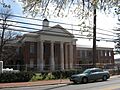
The main entrance to the Prince George's County courthouse in December 2008.
-
The Upper Marlboro courthouse undergoing renovations in April 2008.
-
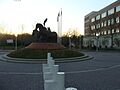
The Three Horse Statue featured prominently in front of the county courthouse in December 2008.


See also
 In Spanish: Upper Marlboro (Maryland) para niños
