
Ural (river) facts for kids
Quick facts for kids Ural |
|
|---|---|

The river Ural from an airplane between Uralsk and Atyrau, Kazakhstan
|
|
 |
|
| Countries | Kazakhstan, Russia |
| Cities | Magnitogorsk, Orsk, Novotroitsk, Orenburg, Oral, Atyrau |
| Physical characteristics | |
| Main source | Ural Mountains |
| River mouth | Caspian Sea 46°53′N 51°37′E / 46.883°N 51.617°E |
| Length | 2,428 km (1,509 mi) |
| Basin features | |
| Basin size | 231,000 km2 (89,000 sq mi) |
| Official name: Ural River Delta and adjacent Caspian Sea coast | |
| Designated: | 10 March 2009 |
| Reference #: | 1856 |
The Ural River is a long river that flows through two countries: Russia and Kazakhstan. It's special because it forms part of the natural border between the continents of Europe and Asia.
The Ural River starts high up in the southern Ural Mountains. From there, it flows all the way down to the Caspian Sea. It is about 2,428 kilometres (1,509 mi) long. This makes it the third-longest river in Europe. Only the Volga and the Danube rivers are longer. It is also one of the longest rivers in Asia.
The river begins near Mount Kruglaya in the Ural Mountains. It flows south through cities like Magnitogorsk. Then it turns west near Orsk and flows for about 300 kilometres (190 mi) to Orenburg. Here, another river called the Sakmara joins it. From Orenburg, the Ural River goes into Kazakhstan. It then turns south again at Oral. Finally, it winds through a wide, flat area. It reaches the Caspian Sea near Atyrau. At its mouth, it forms a cool, tree-like shape called a delta.
Contents
River Journey and Features

The Ural River starts in the Uchalinsky District of Bashkortostan. This is in the South Ural mountains. Here, it's a typical mountain river, about 60 to 80 metres (200 to 260 ft) wide. It then flows into the Yaik Swamp. After the swamp, it gets much wider, up to 5 kilometres (3 mi).
Below Verkhneuralsk, the river changes. It becomes more like a river on flat land. It flows through the Chelyabinsk and Orenburg Oblast regions. From Magnitogorsk to Orsk, the river banks are steep and rocky. The riverbed has many rough spots. After Orsk, the river makes a sharp turn west. It flows through a 45-kilometre (28 mi) long canyon in the Guberlinsk Mountains.
After Uralsk, the river flows from north to south. It passes through the West Kazakhstan Region and Atyrau Region in Kazakhstan. Here, the river gets wider. It has many small lakes and channels. Near where it meets the sea, it splits into two main channels. These are called the Yaik and Zolotoy. They form large wetlands. The Yaik channel is shallow and good for fish. The Zolotoy channel is deeper and boats can use it.
The Ural River's delta looks like a tree or a bird's foot. This shape forms in slow rivers that carry a lot of dirt and flow into a calm sea. There is an island called Shalyga Island in the delta. It is about 13.5 kilometres (8.4 mi) from the mouth of the Zolotoy channel.
Rivers Joining the Ural
Many smaller rivers flow into the Ural River. These are called tributaries. Some of the main ones are the Ilek and the Sakmara. The Or and Tanalyk rivers also join it. Some parts of the river also split off into smaller channels. These are called distributaries, like the Kushum and Bagyrlai.
Europe and Asia Border
Most experts agree that the entire Ural River is the border between Europe and Asia. Sometimes, a smaller river called the Emba River is suggested as the border. But that would push "Europe" much further into Kazakhstan. There is even a bridge over the Ural River in Orenburg. It has monuments on it. One side says "Europe" and the other says "Asia." Because of this river, Kazakhstan has some land that is considered part of Europe. This is why Kazakhstan sometimes joins European sports and political groups.
River Water and Flow

Most of the Ural River's water comes from melting snow. This makes up about 60-70% of its water. Rain doesn't add as much. Most of the river's water flows during spring floods. These floods happen in March and April near the mouth of the river. Upstream, they happen from late April through June. During these floods, the river can get very wide. It can be over 10 kilometres (6 mi) wide near Uralsk. Near the mouth, it can be tens of kilometers wide.
The water level is highest in late April upstream. It is highest in May downstream. The water level can change a lot. It can go up and down by 3 to 4 metres (10 to 13 ft) in the upper part of the river. In the middle, it can change by 9 to 10 metres (30 to 33 ft). In the delta, it changes by about 3 metres (10 ft).
The river usually freezes in early November near its source. It freezes in late November in the middle and lower parts. The ice melts in late March in the lower parts. It melts in early April in the upper parts. The ice doesn't stay for very long.
The river is about 1 to 1.5 metres (3 to 5 ft) deep near its source. It gets deeper as it flows downstream, especially near the mouth. The riverbed is rocky with pebbles and sand upstream. Downstream, it changes to silt, sand, and sometimes clay.
Animals of the Ural River
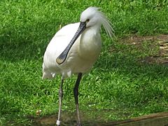
The wetlands near the Ural River delta are very important for birds. Many birds stop here during their long migrations. These areas are home to many special and endangered birds. Some of these include the great white pelican, Dalmatian pelican, and pygmy cormorant. You might also see the greater flamingo, white-headed duck, and Eurasian spoonbill. Other birds like the common crane, black stork, and osprey also live here. Many of these birds visit between April and September. Upstream, you can find birds that live there all year, like grouse and partridge.
The Ural River is also very important for fish. Many fish from the Caspian Sea come into the river to lay their eggs. In the lower parts of the river, there are 47 different kinds of fish. Many of these are Cyprinidae fish, like roach and bream. Sturgeon and herring are also common. Important fish for fishing include sturgeon, roach, bream, perch, carp, and Wels catfish. Some rare fish like the Caspian salmon and sterlet also live here.
Around the river delta, there are about 48 types of animals. Most of these are rodents, like mice and rats. There are also many predators. Some special animals found here are Bobrinski's serotine (a type of bat) and the marbled polecat. Other common animals include raccoon dogs, muskrats, European hares, and wild boars. You might also see elk, foxes, wolves, and saiga antelope. The Turkmenian kulan (a wild donkey) used to live here but might be gone now.
Reptiles and Amphibians
You can find different reptiles near the Ural River. These include bog turtles, common water snakes, rat snakes, and sand lizards. Bog turtles live in all the water areas. Water snakes live on the banks of the river channels. Rat snakes and sand lizards prefer higher, drier areas. Two very rare reptiles are the Caspian whipsnake and Coluber spinalis. For amphibians, the lake frog and green frog are common.
Insects and Other Small Creatures
Insects are very common in the region. There are an estimated 5,000 to 10,000 different kinds! They are a big part of the diet for many birds. Some insects can also carry diseases. Other tiny creatures in the river include protozoa (very tiny single-celled organisms), rotifers, Cladocera, and copepods. Mollusks, like snails and clams, are also found here.
-
Eurasian spoonbill
-
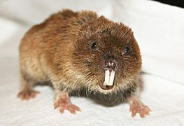
Northern mole vole
-
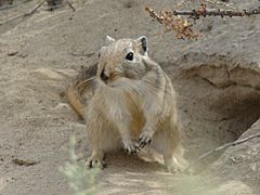
Great gerbil
-
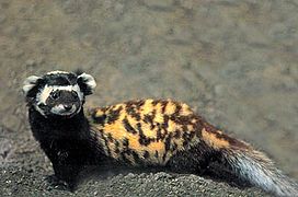
Marbled polecat
-
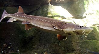
Sturgeon


How People Use the Ural River
The Ural River is very important for people living nearby. Water from the upper parts of the river is used by big factories. These include the Magnitogorsk and Orsk-Khalilovsk metal factories. The lower parts of the river are used for watering crops.
Two large reservoirs (man-made lakes) were built near Magnitogorsk. There is also a power plant near Iriklinskaya village that uses the river to make electricity. Another reservoir and a channel called Kushumsky are below Uralsk.
Boats can travel on the river up to Uralsk. The city of Atyrau has a port. Fishing is a big industry on the Ural River. Fish like sturgeon, perch, herring, bream, carp, and catfish are caught. The delta of the Ural River provides about half of all the fish caught in Kazakhstan.
Farming is also common, especially growing melons and watermelons. The city of Atyrau is also a major center for producing oil in Kazakhstan.
River's Name History
The Ural River has had different names throughout history. In ancient times, around the 2nd century AD, it was called Daïkos. Later, in the 10th century, a Byzantine emperor called it "Geich."
The name Yaik (Яик) was used for a long time. It is still used in the Bashkir language (Яйыҡ) and in Kazakhstan (Жайық). In 1775, the Russian Empress Catherine II of Russia changed the river's name to Ural. This happened after a big rebellion. She wanted to erase the memory of the revolt. So, the Yaik River and the city of Yaitsk were renamed the Ural River and Uralsk. The people living there, the Yaik Cossacks, became the Ural Cossacks.
History Along the Ural River

From the 10th to the 16th centuries, a city called Saray-Jük was on the Ural River. It was an important trading center on the famous Silk Road. In the 13th century, it became a strong base for the Golden Horde. It was destroyed in 1395 by the army of Timur. But it was rebuilt and became the capital of the Nogai Horde in the 15th and 16th centuries. In 1580, it was finally reduced to a small village by the Ural Cossacks.
After Russia took control of the Ural River area in the late 1500s, the banks of the river became home to the Yaik Cossacks. These Cossacks were known for fishing. They caught sturgeon and other related fish in the Ural River and the Caspian Sea. They had many ways of fishing. One famous way was called bagrenye. This involved spearing sturgeon that were resting in their underwater hiding spots in the middle of winter. This special fishing method was only allowed on one day each year. On that day, many Cossacks would gather with their long poles. When a signal was given, they would rush onto the ice. They would break the ice with their poles, then spear and pull out the fish.
Another fishing method was building a fence-like structure called an uchug across the river. This was to catch fish swimming upstream to lay their eggs. Until 1918, an uchug was set up near Uralsk in the summer and autumn. This stopped fish from going further upstream into the Cossacks' land.
The Ural Cossacks, originally called the Yaik Cossacks, did not like it when the government tried to control them. Sometimes, they rebelled. The biggest rebellion was the Pugachev's Rebellion from 1773 to 1775. It involved not only the Ural area but much of southeastern Russia. After the rebellion was stopped, Empress Catherine changed the names of many places involved. This was to make people forget about the revolt.
See also
 In Spanish: Río Ural para niños
