
Van Horn, Texas facts for kids
Quick facts for kids
Van Horn, Texas
|
|
|---|---|

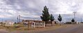
Van Horn in 2018
|
|
 |
|

Van Horn, Texas
Location in Texas

Van Horn, Texas
Location in the United States
|
|
| Country | United States |
| State | Texas |
| County | Culberson |
| Area | |
| • Total | 2.84 sq mi (7.35 km2) |
| • Land | 2.84 sq mi (7.35 km2) |
| • Water | 0.00 sq mi (0.00 km2) |
| Elevation | 4,042 ft (1,232 m) |
| Population
(2020)
|
|
| • Total | 1,941 |
| • Density | 683.45/sq mi (264.08/km2) |
| Time zone | UTC−6 (Central (CST)) |
| • Summer (DST) | UTC−5 (CDT) |
| ZIP Code |
79855
|
| Area code(s) | 432 |
| FIPS code | 48-75032 |
| GNIS feature ID | 1370571 |
Van Horn is a town in Texas, USA. It is the main town, also known as the county seat, of Culberson County. In 2020, about 1,941 people lived there. The number of people living in Van Horn has changed over the years. The town has its own newspaper called The Van Horn Advocate.
Van Horn is the westernmost town in the United States that uses the Central Time Zone. This means it's on the same line of longitude as cities like Cheyenne, Wyoming and Colorado Springs, Colorado. Because of this, it has the latest sunset in early December compared to other towns in the U.S., happening no earlier than 5:56 pm.
Contents
History of Van Horn
People from Texas who spoke English started settling in the Van Horn area in the late 1850s and early 1860s. They supported the Butterfield Overland Mail route, which was a way to deliver mail between San Antonio and El Paso.
The town is named after Lieutenant James Judson Van Horn. He was in charge of an army group at Van Horn Wells starting in 1859. His time there was short because Confederate soldiers took over the post in 1861, and Lt. Van Horn was captured.
More people moved to the area when the Texas and Pacific Railway was built in 1881. Van Horn has several old buildings that are important enough to be on the National Register of Historic Places. One example is the First Presbyterian Church, built in 1901, which is now called Primera Iglesia Bautista.
Geography and Location
Van Horn is located in the southwestern part of Culberson County. Interstate 10 goes through the town. This highway leads about 120 miles (193 km) east to Fort Stockton and about 118 miles (190 km) northwest to El Paso.
Van Horn is also where U.S. Route 90 begins its journey southeast. From Van Horn, this road goes about 73 miles (117 km) to Marfa. Texas State Highway 54 heads north from Van Horn for about 65 miles (105 km) to Pine Springs and the Guadalupe Mountains.
The town covers an area of about 2.8 square miles (7.3 square kilometers), all of which is land. A mountain called Threemile Peak, which is 4,868 feet (1,484 meters) tall, is located northwest of the town.
-
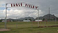
The old Eagle Field, before the 2014 construction of the new stadium, with Threemile Peak in the background
-
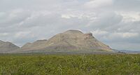
Threemile Peak, with a white "V" for Van Horn on it


Van Horn's Climate
Van Horn has a climate with hot summers and mild winters. It doesn't get a lot of rain.
| Climate data for Van Horn, Texas (1991–2020 normals, extremes 1942–present) | |||||||||||||
|---|---|---|---|---|---|---|---|---|---|---|---|---|---|
| Month | Jan | Feb | Mar | Apr | May | Jun | Jul | Aug | Sep | Oct | Nov | Dec | Year |
| Record high °F (°C) | 80 (27) |
88 (31) |
94 (34) |
100 (38) |
105 (41) |
112 (44) |
108 (42) |
108 (42) |
104 (40) |
98 (37) |
87 (31) |
82 (28) |
112 (44) |
| Mean daily maximum °F (°C) | 59.1 (15.1) |
64.2 (17.9) |
71.6 (22.0) |
78.8 (26.0) |
86.6 (30.3) |
94.5 (34.7) |
92.9 (33.8) |
91.9 (33.3) |
85.9 (29.9) |
78.7 (25.9) |
68.1 (20.1) |
59.2 (15.1) |
77.6 (25.3) |
| Daily mean °F (°C) | 44.6 (7.0) |
49.0 (9.4) |
56.1 (13.4) |
63.4 (17.4) |
71.9 (22.2) |
80.4 (26.9) |
80.6 (27.0) |
79.5 (26.4) |
73.3 (22.9) |
64.3 (17.9) |
53.2 (11.8) |
45.1 (7.3) |
63.4 (17.4) |
| Mean daily minimum °F (°C) | 30.0 (−1.1) |
33.8 (1.0) |
40.6 (4.8) |
47.9 (8.8) |
57.3 (14.1) |
66.4 (19.1) |
68.3 (20.2) |
67.1 (19.5) |
60.6 (15.9) |
49.8 (9.9) |
38.3 (3.5) |
30.9 (−0.6) |
49.2 (9.6) |
| Record low °F (°C) | −7 (−22) |
−3 (−19) |
9 (−13) |
24 (−4) |
31 (−1) |
45 (7) |
53 (12) |
48 (9) |
33 (1) |
19 (−7) |
10 (−12) |
0 (−18) |
−7 (−22) |
| Average precipitation inches (mm) | 0.47 (12) |
0.44 (11) |
0.25 (6.4) |
0.22 (5.6) |
0.49 (12) |
1.10 (28) |
2.05 (52) |
1.95 (50) |
1.50 (38) |
0.94 (24) |
0.42 (11) |
0.49 (12) |
10.32 (262) |
| Average snowfall inches (cm) | 0.7 (1.8) |
0.6 (1.5) |
0.2 (0.51) |
0.0 (0.0) |
0.0 (0.0) |
0.0 (0.0) |
0.0 (0.0) |
0.0 (0.0) |
0.0 (0.0) |
0.1 (0.25) |
0.5 (1.3) |
1.2 (3.0) |
3.3 (8.4) |
| Average precipitation days (≥ 0.01 in) | 2.8 | 2.7 | 1.9 | 1.6 | 3.1 | 4.4 | 7.5 | 7.8 | 5.7 | 4.1 | 2.5 | 2.8 | 46.9 |
| Average snowy days (≥ 0.1 in) | 0.4 | 0.2 | 0.1 | 0.0 | 0.0 | 0.0 | 0.0 | 0.0 | 0.0 | 0.0 | 0.2 | 0.5 | 1.4 |
| Source: NOAA | |||||||||||||
Population Changes Over Time
The number of people living in Van Horn has changed quite a bit over the years.
| Historical population | |||
|---|---|---|---|
| Census | Pop. | %± | |
| 1890 | 450 | — | |
| 1900 | 30 | −93.3% | |
| 1910 | 500 | 1,566.7% | |
| 1920 | 800 | 60.0% | |
| 1930 | 1,600 | 100.0% | |
| 1940 | 2,070 | 29.4% | |
| 1950 | 1,161 | −43.9% | |
| 1960 | 1,953 | 68.2% | |
| 1970 | 2,889 | 47.9% | |
| 1980 | 2,772 | −4.0% | |
| 1990 | 2,930 | 5.7% | |
| 2000 | 2,435 | −16.9% | |
| 2010 | 2,063 | −15.3% | |
| 2020 | 1,941 | −5.9% | |
| U.S. Decennial Census | |||

In 2020, the 2020 United States census counted 1,941 people living in Van Horn. Most of the people living in Van Horn are of Hispanic or Latino background.
Education in Van Horn

Students in Van Horn go to schools in the Culberson County-Allamoore Independent School District. The town is home to the Van Horn High School Eagles.
Getting Around Van Horn
Main Roads
 I-10: This major highway runs along the south side of Van Horn. It connects the town to El Paso (about 117 miles or 188 km west) and San Antonio (about 430 miles or 692 km east). You can also get to I-20 about 47 miles (76 km) to the east.
 SH 54: This state highway goes north from Van Horn. It leads about 55 miles (89 km) north to meet U.S. Route 62. This road also gives you access to Guadalupe Mountains National Park.
 US 90: U.S. Route 90 starts in Van Horn. It goes southeast about 74 miles (119 km) to Marfa. Eventually, it connects back with I-10 in San Antonio.
Other Ways to Travel
- Train: The Union Pacific Railroad has tracks that go through Van Horn.
- Bus: Greyhound Lines has a bus stop at a Super 8 motel in town.
- Airports:
- The closest airport with regular flights is El Paso International Airport. It's about 116 miles (187 km) northwest of Van Horn.
- Culberson County Airport is a smaller airport owned by the county. It's about 3 miles (5 km) northeast of town and is used for public flights.
Space Tourism and Blue Origin
In 2006, news came out that Jeff Bezos, who started Amazon, bought a lot of land north of Van Horn. This land, about 290,000 acres (1,170 square kilometers), is used for his space travel company, Blue Origin.
Blue Origin plans to launch rockets from a place called Corn Ranch near Van Horn. They hope to take people into space for tourism. In 2021, Blue Origin successfully launched its first crew of four people into space and back from Van Horn.
The 10,000-Year Clock

In 2009, it was announced that a very special clock would be built near Van Horn. This clock, called the Clock of the Long Now, is designed to last for 10,000 years! It will be housed underground on the same ranch owned by Jeff Bezos.
Images for kids
-
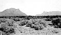
Threemile Mountain (on the left), looking northwest (USGS photo by George B. Richardson, 1913)
-
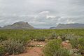
Similar view of Threemile Mountain (left) and Beach Mountains (right) in 2008
-
Culberson County Hospital and Van Horn Rural Health Clinic (2013)
-
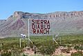
12,800 acre Sierra Diablo Ranch north of Van Horn


See also
 In Spanish: Van Horn (Texas) para niños
