Victoria Park, Brisbane facts for kids
Quick facts for kids Victoria Park |
|
|---|---|

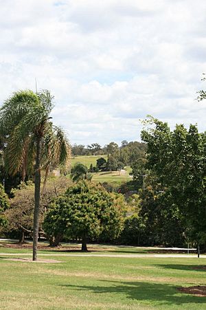
Victoria Park, 2008
|
|
| Location | 454 Gregory Terrace, Spring Hill & Herston, City of Brisbane, Queensland, Australia |
| Official name: Victoria Park | |
| Type | state heritage (built, landscape) |
| Designated | 3 December 2007 |
| Reference no. | 602493 |
| Significant period | 1870s (fabric) 1870s-ongoing (historical use) |
| Lua error in Module:Location_map at line 420: attempt to index field 'wikibase' (a nil value). | |
Victoria Park is a special park in Brisbane, Queensland, Australia. It is located at 454 Gregory Terrace, between the areas of Spring Hill and Herston. This park is important because of its history and beauty. It was added to the Queensland Heritage Register on December 3, 2007, which means it is protected for future generations.
Contents
Discovering Victoria Park's History
Victoria Park is a large, hilly area that covers about 27 hectares. It is surrounded by several roads and the Queensland University of Technology (Kelvin Grove campus). The park was named after Queen Victoria, who was the Queen of Britain at the time. It was officially made a park in 1875.
Today, Victoria Park offers many fun activities. You can find cricket fields, a swimming pool, and a golf course there. It also provides important parking space during the yearly Brisbane Exhibition, known as the Ekka, which happens nearby.
How Victoria Park Began
Europeans first settled in Herston in 1859. However, people were using the area for making bricks and cutting timber as early as the 1820s. This work changed the land, made the water dirty, and pushed out the local Aboriginal people. When it was first created, Victoria Park was much larger, covering about 130 hectares. Over the years, parts of the park were used for other things. Areas like Herston, Bowen Hills, and Spring Hill grew into the park. Houses, schools, hospitals, golf courses, and showgrounds were built on what was once park land.
The land was originally a camping ground for the local Indigenous people, the 'Turrbal' or 'Duke of York clan'. They called this place "Barrambin". Early British settlers named it "York's Hollow". In the 1840s, up to 400 Turrbal people would camp near the waterholes at York's Hollow. By 1860, Aboriginal people could no longer live in the area.
In the mid-1800s, many immigrants came to Brisbane. This was because the New South Wales Government had programs to encourage people to move there. York's Hollow became a temporary home for many of these new arrivals. For example, when the ship Fortitude arrived in 1849, 253 immigrants were allowed to set up a temporary village near the waterholes in York's Hollow. At that time, York's Hollow included the area that is now the Brisbane Showgrounds. As Herston and the surrounding areas grew, these temporary camps were closed, and the people living there had to move. Later in the 1800s, projects were started to make Victoria Park more beautiful, including planting rows of trees.
When Queensland separated from New South Wales in 1859, the new Queensland Government wanted to create open spaces for people in Brisbane. They believed that having parks would be good for the city as it grew. They thought of parks as the "lungs of the city" or "breathing space." A group of people called the Board of Trustees was formed to manage Victoria Park. They made rules for protecting the park and for raising money to improve it. This included renting out parts of the park.
Victoria Park in the Late 1800s
Victoria Park is next to Spring Hill on the Gregory Terrace side. Spring Hill is one of Brisbane's oldest suburbs. People from all walks of life lived there, from those in small homes to wealthy families with large houses overlooking Victoria Park. By the end of the 1800s, Spring Hill was Brisbane's most populated suburb. Victoria Park offered an open space for these residents, especially those living in crowded conditions. From 1870 to 1900, Victoria Park was the biggest open area close to the city center.
In 1877, the Queensland Rifle Association built a rifle range in the park's north-east corner. It was used for fun and for military and police training until 1883. Even though the park was meant for public recreation, the military still had a presence there.
Building a large railway system was important for Queensland's growth. In 1882, a railway line from Roma Street railway station to Sandgate was built through Victoria Park. This line was routed through the park to save money. It split the park into two parts. After the railway, the park was made even smaller when The Hospital for Sick Children was built in 1883. The park's land was also reduced over time to create sports fields for Brisbane Grammar School, Brisbane Girls' Grammar School, and St Joseph's College, Gregory Terrace.
Victoria Park in the Early 1900s
In 1913, Victoria Park was part of an important science experiment. The Carnegie Institution of Washington, a famous science group, studied the Earth's magnetism. They set up small stations around the world, including one in Victoria Park. This helped them measure how the Earth's magnetic field changes. A special sandstone block marking the exact spot was found in 2001. It had "C.I.W. 1913" carved into it.
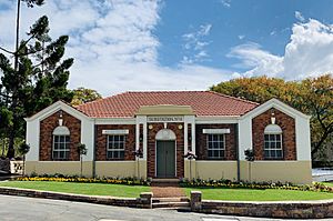
The Brisbane City Council (BCC) Substation No. 4 was built in 1928 near the Bowen Bridge end of Victoria Park. This building helped bring electricity to Brisbane homes and businesses. It was designed by City Architect Alfred Herbert Foster. The substation took large amounts of electricity from power stations and changed it into a form that people could use. After 1925, the Brisbane City Council worked hard to bring electricity to the whole city.
The park's size was reduced again when the Victoria Park Golf Club was built. In the 1920s, many cities in Australia were building public golf courses. In 1922, the Queensland Golf Association suggested building one in Victoria Park. The idea was approved in 1926. This happened after the land set aside for The University of Queensland in Victoria Park was no longer needed. The university had received a large donation to buy its St Lucia site instead. The 18-hole golf course was built during the Great Depression by men who were part of a government work program. The Victoria Park Golf Course opened in 1931. The first Victoria Park Golf Clubhouse was also built in 1931.
More work was done during the Depression to help unemployed people. This included landscaping and improving the park. Gilchrist Avenue was built in 1931 and lined with Silky Oak and Poinciana trees to make the park more beautiful. Drainage was improved in the lower parts of the park to stop flooding, and an existing lake was made into a pretty feature. In 1936, the park entrance at Bowen Bridge Road and Gregory Terrace was improved with stone pillars made of Brisbane Tuff.
Victoria Park During and After World War II
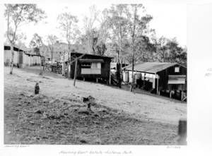
During the Second World War, many temporary military buildings were put up in Victoria Park by the United States forces. After the war started in the Pacific in late 1941, Brisbane became a very busy place for the military. Thousands of American troops stayed there before going to fight in the Pacific. Many of these buildings were huts made of fibrolite. After the war, until 1947, many of these huts were used to house Australian women who had married American soldiers. These women were called "war brides."
After the war, Queensland's population grew very quickly, and there was a big shortage of homes. Temporary housing became very important. The Queensland Housing Commission used the military buildings in Victoria Park. It became the second-largest temporary housing area in Brisbane. Each hut housed several families. By 1950, Victoria Park was a temporary home for 460 families. It is thought that up to 100,000 Queenslanders lived in temporary housing between 1946 and 1960. This shows how important this time was for Victoria Park and for Queensland's history. The temporary housing camps in Victoria Park closed in 1960.
In the 1950s, a big program to plant flowering trees was started on the golf course slopes. Trees like poincianas, oleanders, jacarandas, and flame trees were planted along the fairways. Harry Oakman, who was the Superintendent of Parks and Gardens, was a key person in this project. Harry Oakman was a pioneer in landscape architecture in Australia. He helped fix many of Brisbane's parks that had been damaged by military use during the war.
Victoria Park's Centenary Celebrations
In 1959, Queensland celebrated its Centenary, marking 100 years since it became a separate colony (state) from New South Wales. Victoria Park played a big part in these celebrations in Brisbane. The Centenary Pool Complex was built by the Brisbane City Council as its main contribution. The pool was placed at the south-west corner of Victoria Park, overlooking the park. It was designed by Brisbane City Architect James Birrell.
Another way to celebrate was by planting 1000 eucalypt trees in the south-east of the park. This area was named "The Gundoo Memorial Grove." Students from The Brisbane Girls' Grammar School helped plant these trees. This part of Victoria Park needed to be made beautiful because it had been the site of some of the temporary housing buildings, which had recently been taken down. Harry Oakman believed that planting a grove of eucalypts would be unique for Brisbane. He also thought it would be low-cost, easy to maintain, attractive, and provide shade.
Victoria Park's Recent Changes
In 1968, the Department of Electricity bought land in the south-east of the park and built an office building. They also bought a large storage building that the Queensland Railway Department had used.
In 1988, the lake area in Victoria Park was officially named 'York's Hollow', bringing back its original name.
The Inner City Bypass was finished in 2003. This road helps traffic move directly through the city, reducing congestion in the Brisbane central business district and Fortitude Valley. The bypass runs next to the railway line through Victoria Park. It is another example of how parts of Victoria Park's land have been used for other city developments over time.
What Victoria Park Looks Like
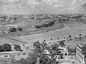
Victoria Park has hilly land that slopes down from Gregory Terrace to the railway line. From the top of the hill, you can see wide views of the Old Museum, the Brisbane Showgrounds, Royal Brisbane Hospital, and even Mt Coot-tha and the Brisbane city center.
At the entrance on Bowen Bridge Road, there are two tall stone gate pillars made of Brisbane Tuff. These pillars have decorative metal lamp holders on top.
The park has large open grassy areas. It is planted with many mature fig trees, eucalypts, and other shade trees, as well as ornamental trees and palms. The Gundoo Memorial Grove, with its many eucalypt trees, is in the south-east part of the park.
Near the corner of Gregory Terrace and Bowen Bridge Road, there is a red brick building called the former BCC Substation No. 4. It has a tiled roof and arched windows. This building fits well with the nearby Old Museum.
The railway and the inner-city bypass run directly through the park, dividing it into two sections. This division is about 150 meters wide. The northern part of the park has picnic areas with barbecues, large lawns, and playing fields. Gilchrist Avenue is now a dead-end street. A wooden and steel footbridge crosses over the lake from the end of Gilchrist Avenue. The lake has water-lilies and tall grasses. At one end of the lake, there is a bronze statue.
Why Victoria Park is Important
Victoria Park is listed on the Queensland Heritage Register because it meets several important criteria:
- It shows how Queensland's history has changed.
Victoria Park tells us about important times in Queensland's history. It was a place where immigrants camped in the mid-1800s. During the Depression years, it was used for government work programs. After the Second World War, it provided temporary homes for war brides and families of soldiers. In 1913, Victoria Park was also the site of an important science experiment. The Carnegie Institution of Washington studied the Earth's magnetism there.
- It shows rare or special parts of Queensland's culture.
Victoria Park has Brisbane City Council Substation No. 4. This might be the oldest substation designed by architect A.H. Foster that is still in its original condition. It shows how buildings were made to be strong, practical, and attractive when electricity was first brought to Brisbane.
- It shows the main features of a certain type of cultural place.
The park is an example of the work of Harry Oakman. He was the Director of Parks for the Brisbane City Council from 1948 to 1963. He was the first trained landscape architect to work for the government in Queensland.
- It is important for its beauty.
Victoria Park is beautiful to look at. It is a landscaped park with hills that offer wide views in all directions. The park has large open grassy areas and is filled with mature fig trees, shade trees, palms, and garden beds. The Gundoo Memorial Grove of eucalypt trees is in the south-east part of the park.
- It has a strong connection with a community or group for social or cultural reasons.
The park is a popular place for both organized sports and casual recreation. It has many sports facilities like cricket pitches, tennis courts, a golf course, a bikeway, and a swimming pool.
 | Percy Lavon Julian |
 | Katherine Johnson |
 | George Washington Carver |
 | Annie Easley |


