
Vogelsberg facts for kids
Quick facts for kids Vogelsberg |
|
|---|---|

Overview map of the Vogelsberg
|
|
| Highest point | |
| Peak | Taufstein |
| Elevation | 773 m above NHN |
| Dimensions | |
| Length | 60 km (37 mi) |
| Area | 2,500 km2 (970 sq mi) |
| Geography | |
| State | Counties of Vogelsbergkreis, Main-Kinzig-Kreis, Wetteraukreis, Gießen and Fulda; Hesse, Germany |
| Range coordinates | 50°32′00″N 9°14′00″E / 50.533333°N 9.233333°E |
| Parent range | East Hesse Highlands |
| Geology | |
| Orogeny | Low mountains, extinct volcanoes |
| Type of rock | Basalt |
The Vogelsberg is a huge mountain range in Hesse, Germany. It's actually a very old, extinct volcano! This makes it Central Europe's largest area made of basalt, a dark, fine-grained volcanic rock. The Vogelsberg formed about 19 million years ago. Its peaks are surrounded by ring-shaped terraces that gently slope downwards.
The main peaks of the Vogelsberg are the Taufstein, which is 773 meters (2,536 feet) high, and Hoherodskopf, which is 763 meters (2,503 feet) high. Both of these peaks are now part of the High Vogelsberg Nature Park, a protected area.


Contents
Where is the Vogelsberg?


The Vogelsberg is located in the Vogelsbergkreis county. It's about 60 kilometers (37 miles) northeast of Frankfurt. You can find it between the towns of Alsfeld, Fulda, Büdingen, and Nidda.
To the northeast, you'll find the Knüll mountains. The Rhön Mountains are to the east, and the Spessart forest is to the southeast. To the southwest, the land becomes flatter in an area called the Wetterau. The Vogelsberg also connects to parts of the West Hesse Highlands in the northwest. The special basalt rocks from the Vogelsberg can be found even further out from the main mountain range.
How the Vogelsberg Formed

The Vogelsberg is the largest connected volcanic area in Central Europe. It covers about 2,500 square kilometers (965 square miles). It's not just one giant shield volcano. Instead, it's made up of many smaller volcanoes that erupted over time. These eruptions created many layers of basalt rock. These layers look like steps or terraces that go down from the high central plateau, called the Oberwald. The Oberwald is between 600 and 773 meters (1,968 and 2,536 feet) high.
The Vogelsberg looks like a flat, shield-shaped volcano today. This shape was created by two things: the land slowly pushing upwards and natural wearing away (erosion) from all sides.
Volcanic Activity
The volcanic activity in the Vogelsberg started about 20 million years ago. It was most active between 17 and 15 million years ago. It finally stopped about 7 million years ago. During this time, the volcanoes mainly produced basaltic lava and pyroclastic deposits (bits of rock, ash, and gas from eruptions).
Over time, the volcanic rocks were worn down by erosion. This process also created red clays and even bauxite, which is used to make aluminum. The iron found in basalt also gathered to form iron ore. People have mined these materials for a long time. Basalt itself is still a popular material for making gravel and building stones.
Different Parts of the Vogelsberg
The Vogelsberg is divided into different natural areas. These divisions are based on how the land slopes and where the rivers flow. Rivers like the Eder, Fulda, Main, and Lahn all have parts of their river systems starting in the Vogelsberg.
Here are the main natural regions of the Vogelsberg:
- Lower Vogelsberg (Unterer Vogelsberg)
- Northern Lower Vogelsberg
- Northwestern Lower Vogelsberg
- Eastern Lower Vogelsberg
- Western Lower Vogelsberg
- Southern Lower Vogelsberg
- Giesel Forest
- High Vogelsberg (Hoher Vogelsberg)
- Western High Vogelsberg
- Eastern High Vogelsberg
- Oberwald
Even though the rocks are similar in most parts of the Vogelsberg, the weather changes. It gets colder towards the center of the mountains. The amount of rain and snow also increases towards the Oberwald, reaching about 1,200 millimeters (47 inches) per year.
The Vogelsberg has areas with stone runs (piles of rocks), raised bogs (wetlands), and old forests. Many hiking trails cross the area, especially in the Oberwald.
The Oberwald

The Oberwald is the very heart of the Vogelsberg. It's almost entirely covered in trees. Its edge is roughly at the 600-meter (1,968-foot) height line. In other parts of the Vogelsberg, you'll see a mix of green pastures, farms, and forests.
Many parts of the Oberwald are protected. For example, the beech forest in the Taufstein Nature Reserve has been left to grow naturally since 1906. You can also find large piles of basalt rocks, called stone runs, on the northern slopes of the Taufstein.
Outer High Vogelsberg
The valleys in the Western and Eastern High Vogelsberg are usually higher than 500 meters (1,640 feet) in the north. Some in the west go down to below 400 meters (1,312 feet). These areas are important because they contain the starting points of many major rivers. The Rhine-Weser watershed, which separates rivers flowing to the Rhine from those flowing to the Weser, runs through here.
Because many original forests were cleared and there's a lot of rain and snow, melting snow can cause flooding. In this part of the Vogelsberg, you'll find forests with many springs, wetlands, and stream valleys. There's also a raised bog and some lakes in the southeast, known as the Vogelsberg Lakes.
Lower Vogelsberg
The basalt areas of the Lower Vogelsberg are generally between 300 and 500 meters (984 and 1,640 feet) high. However, on the western and southwestern edges, near the Wetterau, they can drop below 200 meters (656 feet).
The border with the Büdingen Forest to the south and the Landrücken to the southeast is not just about height. It's also where the rock changes from basalt to a different type of sandstone. The Vogelsberg is like a forest island with special grasses and beech trees.
Giesel Forest
The Giesel Forest is a unique part of the Vogelsberg. It covers about 130 square kilometers (50 square miles). This area is made of a different type of rock, called bunter sandstone, unlike the basalt in the rest of the Vogelsberg.
The Giesel Forest is mostly covered in woods, including pine forests. You can also see large, treeless areas near the huge piles of waste from a potassium salt mine in Neuhof.
Rivers and Water
The Vogelsberg is a very important area for water. It's where several major watersheds meet. This means that rain and snow falling on the Vogelsberg can flow into different large river systems, including the Rhine and the Weser.
Groundwater and spring water from the Vogelsberg are used as drinking water for the Rhine-Main region, a large populated area. People started building water pipes from the Vogelsberg to the city of Frankfurt as early as 1876.
However, taking too much water from the ground can cause problems. Sometimes, springs dry up, cracks appear in buildings, and the ground can sink. The Upper Hessian Water Companies (OVAG) pump out about 30 million cubic meters (7.9 billion gallons) of groundwater every year. About two-thirds of this water goes to Frankfurt.
Rivers and Streams

Many rivers and streams start in the Vogelsberg. They flow outwards from the highest point in all directions. Some of the most important rivers are the Schwalm, Lower Fulda, Kinzig, Nidda, and Ohm. Often, a well-known river is fed by several smaller streams that are almost equally important.
Here are some of the main rivers that start in or are fed by the Vogelsberg:
- Fulda system:
- Schwalm
- Lower Fulda (includes Schlitz and Lüder)
- Main system:
- Kinzig (fed by streams like Salz and Bracht)
- Nidda (includes Nidder and Horloff)
- Lahn system:
- Ohm
It's important to know that some of these rivers get water from other places too. For example, the Schwalm also gets water from the Knüll mountains. The Kinzig itself doesn't flow through the Vogelsberg, but its important streams do.
Lakes and Reservoirs
The Vogelsberg also has several lakes and reservoirs:
- Antrift Reservoir
- Gederner See
- Nidda Reservoir
- Mooser Teiche
- Storage basin of the Nidder Power Station
Wildlife in the Vogelsberg
In recent years, the Eurasian lynx has returned to the Vogelsberg area. There have also been rumors of wolves, and sightings have been confirmed north of the Vogelsberg. Wildcats are also believed to live here, but they are very hard to spot, just like lynxes. Like in most of Hesse, there are many wild boar in the region.
Fun Things to Do in the Vogelsberg
The Vogelsberg is a great place for winter sports. You can go Alpine skiing or cross-country skiing on the Herchenhainer Höhe and Hoherodskopf. There are 55 kilometers (34 miles) of cross-country ski trails!
In summer, you can enjoy hiking and cycling. There are many long-distance cycling routes, like the Volcano Cycleway (Vulkanradweg) and the Vogelsberg Southern Railway Cycleway (Vogelsberger Südbahnradweg). On weekends, special buses called the Vulkan Express run to the high parts of the Vogelsberg. These buses even have bicycle trailers, so you can bring your bike! Many bus routes go to the Hoherodskopf.
The Volcano and Southern Railway Cycleways are paved, so you can also use them for inline skaters. There's a big network of marked cycleways and 70 kilometers (43 miles) of marked mountain bike routes in the Vogelsberg Nature Fitness Park.
The Hoherodskopf is the main tourist spot. Here, you'll find the Nature Conservation Information Centre for the High Vogelsberg Nature Park. There's also a tourist information center for the town of Schotten. Both are open every day. From here, you can explore three nature trails that teach you about geology, nature, and your senses. There's also a summer toboggan run, a tree ropes course, many hiking trails, and several restaurants.
Images for kids
-
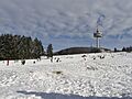
Hoherodskopf
-
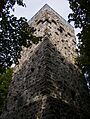
Bismarck tower on the Taufstein
-
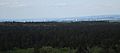
View from the Bismarck Tower on the Taufstein (2015)
-
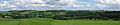
Landscape in the Vogelsberg (2012, Goldener Steinrück).
-
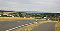
View from the Anterior Vogelsberg between Wermertshausen and Rüddingshausen to the "real" Vogelsberg
-
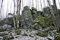
The Uhuklippen natural monument, March 2009
-
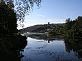
The Nidder in the Vogelsberg
See also
 In Spanish: Vogelsberg para niños
