
Vía Verde de Ojos Negros facts for kids
Quick facts for kids Vía verde de Ojos Negros |
|
|---|---|

Ojos Negros greenway
|
|
| Length | 159.7 km (99.2 mi) |
| Location | Province of Valencia – Province of Castellón – Province of Teruel, Spain |
| Trailheads | Algímia d'Alfara Santa Eulalia del Campo |
| Use | Hiking, cycling, horse riding |
| Elevation change | 1,051 m (3,448 ft) |
| Highest point | 1,218 m (3,996 ft) |
| Lowest point | 183 m (600 ft) |
| Difficulty | Moderate |
| Season | Spring, summer, autumn |
| Sights | Historic town centres of Segorbe, Jérica, Sarrión, La Puebla de Valverde, Teruel Mudéjar Architecture of Aragon (UNESCO World Heritage) Sierra de Espadán, Sierra Calderona, Sierra de Toro, Sierra de Javalambre |
| Surface | Asphalt, compact gravel, earth |
The Ojos Negros Greenway, also known as la Vía Verde de Ojos Negros in Spanish, is a long path in Spain. It stretches for about 160 kilometers (almost 100 miles). This path connects the village of Santa Eulalia del Campo in Aragon with Algímia d'Alfara in the Valencian Community.
This greenway is split into two parts. It is a key part of Spain's "Via Verde" network, which is a huge system of old railway lines turned into paths. This network is managed by the Spanish Railways Foundation. The Ojos Negros Greenway is currently the longest greenway in all of Spain!
Contents
A Journey Through Time: The Railway's Story
Back in the late 1800s, some business people from the Basque region got permission to mine iron in a place called Ojos Negros. They started a company called Compañía Minera de Sierra Menera in 1900.
There was a lot of good quality iron, but it was hard to transport. The company decided to build its own special railway. This railway would carry the iron ore all the way to Puerto de Sagunto, a port city on the Mediterranean Sea.
This railway line was finished in 1903. It was about 200 kilometers long. At that time, it was the longest private railway line in all of Europe!
However, over time, they needed to move even more iron. Because of this, the railway line closed down on July 29, 1972. Later, the mining company went out of business in 1987.
From Railway to Greenway
In 2001, the government of the Valencian Community decided to turn part of the old railway into a greenway. This section went from Algímia d'Alfara to Barracas.
Later, the government of Aragon made a similar choice. They decided to convert their part of the line into a greenway, leading to Santa Eulalia del Campo.
There are still some plans to connect the Ojos Negros Greenway to the city of Valencia. This would happen by extending another greenway called Vía Churra. This extension is expected to be finished around 2020–2021.
Exploring the Route
The Ojos Negros Greenway doesn't follow the old railway line exactly. This is because new buildings and roads have been built since the railway closed. This is especially true where the old railway ran next to the A-23 motorway.
The greenway is divided into two main sections:
Ojos Negros I
This part starts in Algímia d'Alfara in Valencia. It passes through or near towns like Altura, Segorbe, Jérica, Viver, and Caudiel. It ends in Barracas, which is the last town in the province of Castellón before you enter Teruel.
This section is about 70 kilometers long. It climbs about 800 meters from the Mediterranean coast up to the central plateau of Spain. The path changes between asphalt, packed gravel, and earth. Along the way, you'll go through 15 old railway tunnels and cross eight bridges. There are also many rest areas.
Ojos Negros II
This section begins in Barracas (Castellón). It goes through places like Sarrión (known as the world's truffle capital), La Puebla de Valverde, Teruel, and Cella. It finishes in the village of Santa Eulalia del Campo (Teruel).
This part is 91 kilometers long. It crosses the highest point of the Ojos Negros Greenway, called Escandón Pass. This spot is 1218 meters high and about 15 kilometers from Teruel. The path here also changes between asphalt, packed earth, and railway ballast. You'll go through five tunnels and cross 13 viaducts (long bridges).
This section of the greenway is part of a program by the Spanish Ministry of Agriculture, Fishing and Food.
Signs and Lights
The Ojos Negros greenway has many signs. These signs show you the distance, direction, and other helpful information. In the province of Teruel, the signs are part of the "Natural Trails" program.
Some tunnels on the route have lights. These lights might be on all the time or turn on when you approach. However, it's a good idea for everyone, especially cyclists, to bring their own lights.
Weather on the Greenway
The coast of Valencia has a warm Mediterranean climate. This means hot, dry summers and mild, wet winters. It rarely freezes near the coast.
The province of Teruel has a cold, semi-dry climate. Summers are warm to hot, but winters are dry and cold. Snow is common in winter. The best times to visit the greenway are spring and autumn. This avoids the very hot summers in Valencia and the cold, snowy winters in Teruel.
How Easy Is It?
The Ojos Negros greenway is not very difficult. Like most old railway lines, it has a gentle slope, usually between 3-5%. This makes it suitable for people walking, cycling, horse riding, and even those with disabilities.
Places to Stay
There are many places to stay along the Ojos Negros greenway. You can find hostels, hotels, campsites, cabins, and private houses.
Getting There
The greenway often runs next to the main railway line that goes from Sagunto to Teruel and Zaragoza. There are several train stations nearby, including Sagunto, Segorbe, Barracas, and Teruel.
Also, a local train service (C-5 line) stops at towns on the first section of the route. These include Estivella, Algímia d'Alfara, Soneja, Segorbe, Navajas, Jérica, and Caudiel. If you plan to bring your bike on the train, it's a good idea to check with the train company (RENFE) first.
The A-23 motorway also follows the greenway closely. This means you can easily access the path from many towns and villages along the way.
What to See Along the Way
The route passes through many interesting places with cool buildings. These include:
- The city of Segorbe, with its cathedral and old medieval walls.
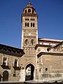
- Jérica, which has a special Mudéjar tower. This tower is so important it's been declared a national historic monument!
- Other towns like Albentosa, Sarrión, La Puebla de Valverde, and Teruel.
The first section of the greenway (Ojos Negros I) goes through or near 18 Protected Natural Areas. These include Sierra Calderona and Sierra del Espadán. You'll also see beautiful Mediterranean pine, oak, and juniper forests.
The second section (Ojos Negros II) passes through or near nine protected natural areas. These include places like Los Sabinares del Puerto de Escadón and Sierra de Javalambre. You'll also cross the valleys of the Alfambra and Jiloca rivers.
Images for kids
-
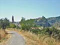
The town of Jérica seen from the Ojos Verdes greenway.
-
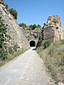
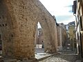
Tunnel on the Via Verde de Ojos Negros near Segorbe.
-
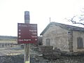
Signage at Santa Eulalia del Campo station.
-
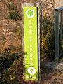
Route marker sign near Algar de Palancia in Valencia.
-
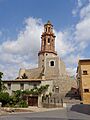
The Mudejar bell tower in Jérica
-
Detail of 14th-century aqueduct in Segorbe
-
Hermitage of Saint Roch, Albentosa
-
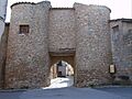
Teruel Gate, Sarrión
-
The tower of Teruel Cathedral

.jpg)


See also
 In Spanish: Vía Verde de Ojos Negros para niños
