Wallula, Washington facts for kids
Quick facts for kids
Wallula, Washington
|
|
|---|---|

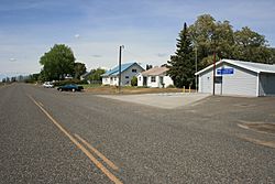
Main Street in 2008
|
|

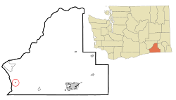
Location of Wallula, Washington
|
|
| Country | United States |
| State | Washington |
| County | Walla Walla |
| Area | |
| • Total | 0.1 sq mi (0.3 km2) |
| • Land | 0.1 sq mi (0.3 km2) |
| • Water | 0.0 sq mi (0.0 km2) |
| Elevation | 423 ft (129 m) |
| Population
(2020)
|
|
| • Total | 140 |
| • Density | 1,400/sq mi (470/km2) |
| Time zone | UTC-8 (Pacific (PST)) |
| • Summer (DST) | UTC-7 (PDT) |
| ZIP code |
99363
|
| Area code | 509 |
| FIPS code | 53-75985 |
| GNIS feature ID | 1512771 |
Wallula is a small community in Walla Walla County, Washington, in the United States. It is known as a census-designated place (CDP), which means it's a special area defined by the government for counting people. In 2020, about 140 people lived there.
Contents
History of Wallula
Wallula has a rich history, especially because of its location near important rivers.
Early Explorers and Native Americans
- In 1806, the famous Lewis and Clark Expedition visited this area. They were on their way back from the Pacific Ocean.
- They stayed for three days with Chief Yallept and his Walla Walla people. These Native Americans were related to the Nez Perce.
- The explorers also met about a hundred Yakama people.
- During their visit, Lewis and Clark learned about a shorter path to the Nez Perce lands. This new route saved them about 80 miles.
European Settlement and Trading Posts
- In 1811, another explorer named David Thompson traveled down the Columbia River.
- He set up a pole and a sign near where the Snake River joins the Columbia. He claimed the land for Great Britain.
- Thompson also announced that the North West Company, a fur trading business, planned to build a trading post there.
- European settlement officially began in 1818. The North West Company built Fort Nez Perce near the mouth of the Walla Walla River.
- They chose this spot to compete with the Hudson's Bay Company for the valuable fur trade in the Pacific Northwest.
- This trading post stayed active until 1855.

Railroad Development
- The first railroad connecting Walla Walla to the Columbia River at Wallula started in 1871.
- This 30-mile (48 km) long line was called the Walla Walla and Columbia River Railroad. It was finished on October 23, 1875.
- To save money, the first tracks were made of wood with thin iron strips on top!
- Later, this railroad became part of the Northern Pacific Railroad.
- In 1883, the Northern Pacific finished its main line from St. Paul, Minnesota, all the way to Wallula.
- They built a railroad bridge across the Columbia River. This bridge connected their tracks to the Oregon Railway and Navigation Company tracks on the south side of the river.
Geography
Wallula is located at 46°5′4″N 118°54′23″W / 46.08444°N 118.90639°W. It covers a total area of about 0.1 square miles (0.3 square kilometers), and all of it is land.
Wallula Gap
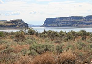
- A famous natural landmark called the Wallula Gap is very close to the community.
- The Wallula Gap is a water gap where the mighty Columbia River cuts through a mountain range. It's a very impressive sight!
Population and Community
| Historical population | |||
|---|---|---|---|
| Census | Pop. | %± | |
| 2000 | 197 | — | |
| 2010 | 179 | −9.1% | |
| 2020 | 140 | −21.8% | |
Wallula is a small community. In 2000, there were 197 people living there. By 2010, the population was 179, and in 2020, it was 140. Most people in Wallula are White, but about 11% are from other races. About 16% of the population is of Hispanic or Latino background.
Local Businesses
- A large paper mill is located in Wallula. It belongs to the Packaging Corporation of America.
- This mill was built in 1958 and makes materials for corrugated shipping boxes.
- Besides the paper mill, Wallula also has a U.S. Post Office and an auto wrecking yard.
See also
 In Spanish: Wallula (Washington) para niños

