Warne, North Carolina facts for kids
Quick facts for kids
Warne, North Carolina
|
|
|---|---|

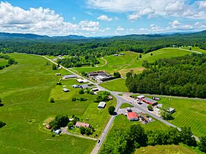
An aerial photo of Warne in 2024
|
|
| Motto(s):
Where your welcome is never "Warne" out
|
|
| Country | United States |
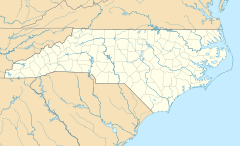
| State | North Carolina |
| County | Clay |
| Elevation | 1,736 ft (529 m) |
| Time zone | UTC-5 (Eastern (EST)) |
| • Summer (DST) | UTC-4 (EDT) |
| ZIP codes |
28909
|
| Area code(s) | 828 |
| GNIS feature ID | 1020542 |
Warne (pronounced "worn") is a small, unincorporated community in Clay County, North Carolina, United States. This means it's a group of homes and businesses that isn't officially a town or city. In 2010, Clay County had about 10,587 people. This was a big jump of 20.6% since 2000. Warne is actually closer to the capital cities of five other states than it is to Raleigh, the capital of North Carolina!
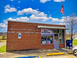
Warne is located about 1,736 feet (529 meters) above sea level. It covers an area of about 8.05 square miles (20.85 square kilometers). The community has its own volunteer fire department and a post office with the ZIP code 28909.
Contents
History of Warne
The land where Warne is now was originally home to the Native American Cherokee people.
- The Warne Post Office opened in 1887.
- Construction on US 64, a major road connecting Hayesville, Warne, and Brasstown, began in 1921.
- Around the 1930s, a gold mine was active in Warne.
- Since 1957, Lidseen of North Carolina, Inc., a company that makes metal products, has had a factory in Warne. It's one of the few manufacturing companies in Clay County.
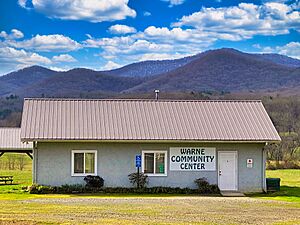
- The Warne community center was built in 1998. It's used as a place for people to vote.
Geography and Location
Warne's Landscape
Warne is found in the southeastern United States, in the western part of North Carolina. It's about halfway between big cities like Atlanta and Knoxville. Warne is nestled in the Blue Ridge Mountains. This mountain setting helps the area stay natural and rural. You can find lots of wildlife here, including bears, deer, foxes, and even elk that have been brought back to the area.
Warne is about 10 miles (16 kilometers) north of Brasstown Bald. This is the highest mountain in Georgia, standing at 4,784 feet (1,458 meters) above sea level.
Warne's Climate
Warne has a humid subtropical climate. This means it has hot, humid summers and mild winters. Sometimes, winters can get cold, but usually they are not too harsh compared to other parts of the U.S.
- In July, the average high temperature is around 85°F (29°C). The average low is about 55°F (12.8°C). Temperatures can sometimes go above 100°F (38°C).
- January is the coldest month. The average high is 48°F (9°C), and the average low is 33°F (0.6°C).
Warne gets a lot of rain throughout the year, about 55.9 inches (1,420 mm) annually. Heavy snowstorms, called Blizzards, are rare but can happen. One famous blizzard in March 1993, known as the 1993 Storm of the Century, affected the entire Eastern United States.
| Month | Jan | Feb | Mar | Apr | May | Jun | Jul | Aug | Sep | Oct | Nov | Dec |
|---|---|---|---|---|---|---|---|---|---|---|---|---|
| Average high Fº (Cº) | 47.8 (8.8) | 52.2 (11.2) | 61.1 (16.2) | 69.9 (21.0) | 77.3 (25.2) | 83.3 (28.5) | 85.8 (29.9) | 85.6 (29.8) | 80.7 (27.0) | 71.8 (22.1) | 61.9 (16.5) | 51.4 (10.8) |
| Average low Fº (Cº) | 24.1 (-4.4) | 26.1 (-3.3) | 32.9 (0.5) | 39.9 (4.4) | 49.1 (9.5) | 56.8 (13.8) | 61.4 (16.3) | 60.9 (16) | 54.8 (12.7) | 41.6 (5.3) | 34.2 (1.2) | 26.8 (-2.9) |
| Precipitation inches (mm) | 5.2 (132) | 5.2 (132) | 6.0 (152.4) | 4.6 (116.8) | 4.6 (116.8) | 4.2 (106.7) | 5.5 (139.7) | 4.1 (121.9) | 3.7 (94.0) | 3.3 (83.2) | 4.1 (104.1) | 4.8 (121.9) |
Communities Near Warne
Here are some towns and communities located within about 15 miles (24 kilometers) of Warne:
People and Economy
Warne's Population (Demographics)
Based on the 2000 Census, Warne had 573 people living in 317 households. This means there were about 71 people per square mile (27 per square kilometer).
- Out of 317 households, 227 were lived in, 90 were empty, and 71 were used only sometimes, like for vacations.
- Most homes (91.2%) were owned by the people living in them, while 8.8% were rented.
- The average number of people in a rental home was 12% more than in an owned home.
- The average value of a house was $81,300.
- About 16.7% of rental homes were empty.
Looking at the 227 occupied homes:
- 30.8% had children under 18 living there.
- 68.3% were married couples.
- 5.7% had a female head of household with no husband.
- 22.9% were not families (meaning people living alone or with non-relatives).
- 18.5% of all households had just one person living there.
- 10.6% had someone living alone who was 65 or older.
- The average household had 2.52 people, and the average family had 2.89 people.
The community's population was spread out by age:
- 20.8% were under 18.
- 6.8% were 15 to 19.
- 14.5% were 20 to 34.
- 33.0% were 35 to 54.
- 12.6% were 55 to 64.
- 16.3% were 65 or older.
- The average age was 41.9 years.
Most Warne residents (98.3%) were White. About 1.4% were African American, 3% were Hispanic or Latino (of any race), and 0.3% were of other races.
After 2000, Warne's population numbers were not counted separately.
Jobs in Warne (Economy)
The biggest job areas in Warne are sales and office work, employing about one-third (32.5%) of the people. Next are jobs in production and transportation, which employ almost one-fourth (22.5%) of the population.
- The service industry provides jobs for almost one-fifth (17.5%) of the working population.
- Construction, mining, and maintenance jobs employ 15.7% of people.
- The remaining 12.1% work in management or professional fields.
Household Income
- Only 1.9% of households make less than $10,000 per year.
- The largest group, 36.9%, makes between $15,000 and $24,999 per year.
- 16.8% make between $50,000 and $74,999 per year.
- 20.1% make between $35,000 and $49,999 per year.
- Another 22% make between $50,000 and $74,999 per year.
- Only 2.3% make over $75,000 per year.
About 8.4% of people in Warne are unemployed. Also, 3.9% of people live below the poverty line. The average household income is $33,120.
Culture and Recreation
Arts and Local Culture
Warne is part of Brasstown Township. It is close to many places that are important for local culture. One example is the John C. Campbell Folk School. This school offers classes in traditional and modern crafts, like basketry.
Places of Worship (Religion)
Local churches in the Warne area include Mount Pisgah Baptist Church, Shady Grove Church, and Copperhill Church.
Parks and Outdoor Fun
Warne is a very rural area. It is surrounded by lots of wildlife, open countryside, and national forests.
- It is only about 0.5 miles (0.8 kilometers) north of the Nantahala National Forest.
- The Chattahoochee National Forest is about 1.8 miles (2.9 kilometers) north.
- Warne is 5.5 miles (8.9 kilometers) west of Chatuge Lake.
- It is 11.8 miles (19 kilometers) northeast of Nottely Lake.
- The famous Appalachian Trail is about 15 miles (24 kilometers) west.
Education in Warne
The public schools in Clay County are managed by the Clay County Board of Education. The school system is small, with about 1,250 students. All students attend three schools located on one campus.
- All schools are approved by the North Carolina State Board of Education.
- Hayesville High School is also approved by the Southern Association of Colleges and Schools.
- Test scores for these schools are consistently in the top 10% of all schools in North Carolina.
- Hayesville Elementary School teaches students from kindergarten to 4th grade. It has about 450 students. This school has been rated "Exemplary" every year since the state's ABCs program started.
- Hayesville Middle School teaches grades 5–8 and has about 400 students. It has been called a "School of Distinction" or "School of Excellence" every year since the ABCs program began.
- Hayesville High School teaches grades 9–12 and also has about 400 students. It has the best SAT scores of any school in the area.
Media and News
Warne and the areas around it get news and entertainment from several local TV and radio stations, as well as newspapers.
- Local TV channels include W50AB (Channel 50) from Hiawassee, Georgia; W42AT (Channel 42) from Hayesville, North Carolina; and W31AN (Channel 31) from Murphy, North Carolina.
- Warne is served by 11 local radio stations. Some are based in Murphy, North Carolina (WCVP-AM 600, WCNG-FM 102.7, WKRK-AM 1320). Others are from Young Harris, Georgia (WACF-FM 95.1, WYHG-AM 770), Robbinsville (WCVP-FM 95.9), Clayton, Georgia (WGHC-AM 1400), and Franklin, North Carolina (WFSC-AM 1050, WPFJ-AM 1480, WFQS-FM 91.3, WNCC 96.7).
- Clay County's local newspaper is the Clay County Progress. Other nearby newspapers are the Cherokee Scout and the Towns County Herald.
Community Services (Infrastructure)
Getting Around (Transportation)
Warne is located on Old Highway 64. This road connects Hayesville to the northeast and Brasstown to the northwest. Young Harris Road connects Warne to State Road 515 in Young Harris, Georgia.
- The Western Carolina Regional Airport (KRHP), also known as Murphy Airport or Andrews Airport, is about 20 miles (32 kilometers) north of Warne. It's located between the towns of Andrews and Murphy.
- The Blairsville Airport (KDZJ) is about 16.8 miles (27 kilometers) southwest of Warne, near Blairsville, Georgia.
Utilities and Services
- Electricity for Warne comes from Blue Ridge Mountain Electric Membership Corporation. This company is owned by its members and buys electricity from the Tennessee Valley Authority (TVA). It then delivers power to homes and businesses in parts of Georgia and North Carolina.
- Natural gas is supplied by Piedmont Gas. This company serves over a million customers in North Carolina, South Carolina, and Tennessee. They also have a foundation that supports the communities they serve.
- Trash and waste from homes and businesses are taken to a landfill.
Healthcare
Erlanger Western Carolina Hospital is located in Peachtree. It has 57 hospital beds and a nursing home with 120 beds.
See also
 In Spanish: Warne (Carolina del Norte) para niños
 | James B. Knighten |
 | Azellia White |
 | Willa Brown |


