
Warrior Run (West Branch Susquehanna River tributary) facts for kids
Quick facts for kids Warrior Run |
|
|---|---|
 |
|
| Physical characteristics | |
| Main source | Delaware Township, Northumberland County, Pennsylvania |
| River mouth | West Branch Susquehanna River at Delaware Township, Northumberland County, Pennsylvania 41°04′24″N 76°51′18″W / 41.07325°N 76.85512°W |
| Length | 9.5 mi (15.3 km) |
| Basin features | |
| Progression | West Branch Susquehanna River, Susquehanna River, Chesapeake Bay |
| Basin size | 21.6 sq mi (56 km2) |
Warrior Run (also called Warrior Run Creek) is a small river in Northumberland County, Pennsylvania, USA. It flows into the West Branch Susquehanna River. The river is about 9.5 miles (15.3 km) long. The area of land that drains into Warrior Run, called its watershed, covers 21.6 square miles (56 square kilometers). This watershed is mostly in Northumberland and Lycoming Counties.
The main types of land use in the watershed are farming and forests. Towns like Watsontown, Turbotville, and McEwensville are located in or near this area. People from Europe first settled near Warrior Run in the early 1770s. They built several mills and forts along the river.
Contents
Where Does Warrior Run Flow?
Warrior Run starts in the northeastern part of Delaware Township. This is in a hilly area called the Muncy Hills, close to the border with Lycoming County. The stream flows south, running alongside Interstate 180.
As it leaves the Muncy Hills, it briefly goes through Lewis Township. It then passes under Pennsylvania Route 54. The stream flows near Warrior Run High School and the community of Warrior Run. After this, it turns southwest and goes back into Delaware Township.
It continues flowing southwest past McEwensville. It then goes under Interstate 180 again. The stream keeps flowing west, next to Pennsylvania Route 44. Finally, Warrior Run crosses under Pennsylvania Route 44 and Pennsylvania Route 45. It then empties into the West Branch Susquehanna River near the southern edge of Watsontown.
Smaller Streams Joining Warrior Run
All the smaller streams that flow into Warrior Run do not have official names.
What Is the Land Like Around Warrior Run?
The area around Warrior Run is part of the Ridge-and-Valley Appalachians geographic region. This means it has long, parallel ridges and valleys. The highest part of the watershed is in the north, where the Muncy Hills are. The river's starting point is about 300 feet (91 m) higher than where it ends.
About 35% of the rocks in the upper part of the Warrior Run watershed are layers of different types of sedimentary rock. These include rocks from the Hamilton Group and the Old Port Formation. The other 65% of the rocks are mostly sandstone and shale. These rocks are found throughout the northern and central parts of the watershed.
The most common type of soil in the Warrior Run watershed is called the Berks-Weikert-Bedington series. This soil is a shaly silt loam. Other common soils include the Watson-Berks-Alvira series and the Hagerstown-Edom-Washington series. These soils are found in different parts of the watershed.
There is a lot of soil erosion happening along the banks of Warrior Run. This means the soil is washing away into the river.
How Clean Is the Water in Warrior Run?
Warrior Run carries a lot of sediment (like dirt and small rocks) each day. The Environmental Protection Agency (EPA) says this amount needs to be reduced. A lot of this sediment comes from farms and river banks.
The river also has a daily load of phosphorus. The EPA says this amount also needs to be reduced. Most of the phosphorus comes from farmlands and groundwater. Some also comes from septic systems and stream banks.
Unfortunately, the EPA considers all the streams in the Warrior Run watershed to be "impaired." This means their water quality is not good enough.
Between 2005 and 2013, the average yearly rainfall in the Warrior Run watershed was about 37.74 inches (95.9 cm).
The towns of Turbotville and McEwensville release treated sewage into streams within the Warrior Run watershed.
The Warrior Run Watershed Area
The Warrior Run watershed covers an area of 21.6 square miles (56 square kilometers). It is mainly in Delaware Township and Lewis Township in Northumberland County. A small part is also in Muncy Creek Township in Lycoming County. Part of Turbotville is also within the watershed.
The main roads in the watershed are Interstate 180 (which runs north-south) and Pennsylvania Route 54 (which runs east-west). There are also many local roads in the area.
About 55% of the Warrior Run watershed is used for farming. Forests cover 35% of the area, and developed land (like towns and roads) makes up 10%. Most of the forested land is in the northern part of the watershed. The watershed also has about 17.3 acres of wetlands.
A Look Back: History of Warrior Run
Warrior Run has been important to the history of Northumberland County since Europeans first settled there.
A historic Native American trail once ran from Northumberland to Muncy. This trail passed by the mouth of Warrior Run and the Muncy Hills. By the late 1800s, a public road followed this old trail. John Shikellamy, the son of a Native American chief, had a hunting lodge at the mouth of Warrior Run. It was known as the Warrior's Camp.
In May 1769, a large piece of land (609 acres) at the mouth of Warrior Run was surveyed. This land included the area where Watsontown is today. Captain Daniel Piper later owned this land. European settlers arrived further upstream in 1772. These were the first European settlers in that specific area. They included Jacob Freeland and the Vincent family.
To protect the settlers from Native American attacks, Fort Freeland was built in 1775. It was a stockaded log house with half an acre inside its walls. The fort offered a good view of the river for about a mile in both directions. However, it was destroyed on July 28, 1779. About 100 British soldiers and 200 Native American warriors attacked it.
Hawkins Boone, a relative of the famous Daniel Boone, built Fort Boone at the mouth of the stream. Another fort, Fort Meninger, was also located there. John Watson had the idea to build a community at the mouth of Warrior Run, which he started in 1794. It was first called Slabtown, but its name was later changed to Watsontown.
Daniel Vincent bought 400 acres around Fort Freeland and built a mill there. This mill was updated in 1818 and was still in use in the early 1900s. Jacob Freeland built a gristmill (a mill for grinding grain) on the stream in 1773. This mill was known as Freeland's Mill. Another mill, the Wilson Mill, was also built on the stream. In the 1840s, Watsontown had one or two mills on Warrior Run.
Nature Around Warrior Run
In areas where Warrior Run flows through farmland, there are very few riparian buffers. These are natural areas of plants and trees along the riverbanks that help filter water and prevent erosion. Also, farm animals can sometimes get into the stream in certain places.
Fun Activities at Warrior Run
The Warrior Run Community Corporation plans to create a walking trail along Warrior Run. This trail would go from McEwensville to the Muncy Hills. Since 2006, there has been a 5-kilometer (3.1-mile) footrace. This race partly follows Warrior Run near the Warrior Run Middle School.
Images for kids
-
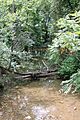
A view of Warrior Run.
