Wells River, Vermont facts for kids
Quick facts for kids
Wells River, Vermont
|
|
|---|---|
|
Village
|
|
 |
|
| Country | United States |
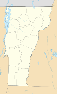
| State | Vermont |
| County | Orange |
| Area | |
| • Total | 1.91 sq mi (4.96 km2) |
| • Land | 1.88 sq mi (4.86 km2) |
| • Water | 0.04 sq mi (0.10 km2) |
| Elevation | 430 ft (131 m) |
| Population
(2020)
|
|
| • Total | 431 |
| • Density | 225.7/sq mi (86.90/km2) |
| Time zone | UTC-5 (Eastern (EST)) |
| • Summer (DST) | UTC-4 (EDT) |
| ZIP code |
05081
|
| Area code(s) | 802 |
| FIPS code | 50-78025 |
| GNIS feature ID | 1460106 |
|
Wells River Village Historic District
|
|
| Location | Main, Center, Grove, Cross, and Water Sts., Newbury, Vermont |
| Area | 39 acres (15.8 ha) |
| Architectural style | Classical Revival, Other, Federal, Late Victorian |
| NRHP reference No. | 83003217 |
| Added to NRHP | July 28, 1983 |
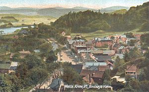
Wells River is a small village located in the town of Newbury. It's found in Orange County, Vermont, in the United States. In 2020, about 431 people lived here. The village center is where two main roads, U.S. Routes 5 and 302, meet.
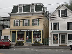
The central part of Wells River is a special place. It was added to the National Register of Historic Places in 1983. This means it has many old and important buildings. The area covers about 390 acres and shows different building styles from the 1800s. These styles include Classical Revival, Federal, and Late Victorian designs.
Contents
History of Wells River
The area where Wells River is now was first known as Governor's Right. This was because 500 acres of land were given to Governor Benning Wentworth of New Hampshire. Later, a person named Er Chamberlin bought the land. He built a gristmill on the Wells River. A gristmill is a place where grain is ground into flour.
Wells River became an important place for trade. This was because it was at the "head of navigation" for the Connecticut River. This means it was as far up the river as boats could easily travel. Canal boats would float down the river. They carried things like lumber, clapboards (wooden boards for houses), and shingles (for roofs). On their way back, they brought goods like iron, salt, rum, and molasses. In the 1830s and 1840s, a famous hotel called the Coosuck House was run by Jacob Kent Jr. in Wells River.
The Arrival of Railroads
On November 6, 1848, the Connecticut and Passumpsic Rivers Railroad opened in Wells River. This new way of transport made river boats less important. Then, in 1853–1854, another railroad, the Boston, Concord and Montreal Railroad, reached Woodsville, New Hampshire. Woodsville is just across the Connecticut River. This railroad built offices and repair shops there. This made Woodsville a busy railway town.
The railroad replaced an old bridge over the river. The new bridge had two levels. The bottom level was for cars and people (a toll highway). The top level had railroad tracks. In 1903, a new steel bridge was built in the same way. In 1873, the Montpelier and Wells River Railroad was finished. This made Wells River an even more important railroad junction.
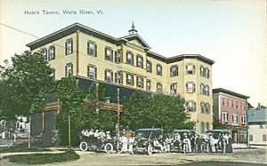
Historic Buildings in the Village
Wells River has many old and interesting buildings. Some of the most important historic structures in the village include:
- Wells River Congregational Church, on Main Street. Parts of it were built in 1839, 1869, and 1894.
- Wells River Graded School, also on Main Street, built in 1874. This school is so important it's listed separately on the National Register.
- Mulliken-Davis Store, on Main Street, built around 1871.
- U.S. Post Office, at 26 Main Street, built around 1840.
- Baldwin Memorial Library, on Main Street, also built around 1840.
- G. Gould House, at 7 Main Street, with parts from 1794 and 1830.
- Baldwin-Simonds House, at the North end of Main Street, built around 1890.
- Wells River Village Hall, on Cross Street, built in 1908.
Geography and Location
The village gets its name from the Wells River. This river flows into the Connecticut River right at the eastern edge of the village. The village covers about 2.0 square miles (5.1 square kilometers) of land.
Major roads cross through Wells River. These include Interstate 91, U.S. Route 5, and U.S. Route 302. Routes 5 and 302 run together for a short distance. Then, Route 302 crosses the Connecticut River into New Hampshire.
Population Information
| Historical population | |||
|---|---|---|---|
| Census | Pop. | %± | |
| 1880 | 513 | — | |
| 1890 | 526 | 2.5% | |
| 1900 | 565 | 7.4% | |
| 1910 | 608 | 7.6% | |
| 1920 | 606 | −0.3% | |
| 1930 | 553 | −8.7% | |
| 1940 | 527 | −4.7% | |
| 1950 | 570 | 8.2% | |
| 1960 | 472 | −17.2% | |
| 1970 | 419 | −11.2% | |
| 1980 | 396 | −5.5% | |
| 1990 | 424 | 7.1% | |
| 2000 | 325 | −23.3% | |
| 2010 | 399 | 22.8% | |
| 2020 | 431 | 8.0% | |
| U.S. Decennial Census | |||
In the year 2000, there were 325 people living in Wells River. There were 156 households, which are groups of people living in one home. About 25% of these households had children under 18 living with them. Most people in the village were White. The average age of people in the village was 44 years old.
Notable People from Wells River
Some important people have connections to Wells River:
- Jacob Kent Jr. was a hotel owner and a public official. He served as the Sheriff for Orange County and as a U.S. Marshal for Vermont.
- William A. Russell was a U.S. Congressman from Massachusetts.
- Abel Underwood was a prosecutor, a lawmaker, and a judge in Vermont.
See also
 In Spanish: Wells River para niños
 | James B. Knighten |
 | Azellia White |
 | Willa Brown |


