
White Mountain (Washington) facts for kids
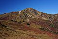
White Mountain is a 7,043-foot (2,147-meter) mountain in the Glacier Peak Wilderness area of the North Cascades in Washington state. This mountain sits on top of the Cascade Range, right on the border between Snohomish County and Chelan County. It's also found where the Mount Baker-Snoqualmie National Forest meets the Wenatchee National Forest.
White Mountain is about 3.04 miles (4.89 km) west-southwest of Kololo Peaks and just north of White Pass. The famous Pacific Crest Trail goes along the southern side of the mountain. Water from the mountain flows into the White River, White Chuck River, and Sauk River.
Quick facts for kids White Mountain |
|
|---|---|

White Mountain
|
|
| Highest point | |
| Elevation | 7,043 ft (2,147 m) |
| Prominence | 523 ft (159 m) |
| Geography | |

White Mountain
Location in Washington (state)

White Mountain
Location in the United States
|
|
| Location | Snohomish County, Washington Chelan County, Washington, U.S. |
| Parent range | Cascade Range |
| Topo map | USGS Glacier Peak West |
| Climbing | |
| Easiest route | Hiking |

How White Mountain Was Formed
The North Cascades mountains have very rough and jagged shapes. They have sharp peaks, tall spires, long ridges, and deep valleys carved by glaciers. These amazing shapes and big changes in height were created by geological events that happened millions of years ago. These events also led to different climates across the Cascade Range.
The Cascade Mountains started forming millions of years ago, during a time called the late Eocene Epoch. This happened because the North American Plate was slowly moving over the Pacific Plate. This movement caused many periods of volcanic activity, where molten rock erupted. Glacier Peak, a large stratovolcano, began to form in the middle of the Pleistocene period. It is about 5.22 miles (8.40 km) north-northeast of White Mountain. Because Glacier Peak is so close, volcanic ash is common in the area. This ash makes the soil very rich, which helps many wildflowers grow.
During the Pleistocene period, which was over two million years ago, glaciers moved forward and then melted back many times. As they moved, they scraped away the land, leaving behind piles of rock. The river valleys in the area have a "U" shape, which is a clear sign that glaciers once moved through them. The lifting of the land (called uplift) and cracks in the Earth's crust (called faulting), along with the glaciers, are the main reasons why the North Cascades have such tall peaks and deep valleys today.
Weather and Climate
White Mountain is in a marine west coast climate zone. This means it's near the ocean and has mild, wet weather. Most weather systems start over the Pacific Ocean and move northeast towards the Cascade Range. As these weather systems reach the North Cascades, the tall mountains force the air to rise. This rising air cools down and drops its moisture as rain or snow onto the Cascades. This process is called Orographic lift.
Because of this, the western side of the North Cascades gets a lot of rain and snow, especially in winter. Since the climate is mild and close to the Pacific Ocean, temperatures west of the main Cascade peaks rarely go below 0°F (-18°C) or above 80°F (27°C). In winter, it's usually cloudy. But in summer, high-pressure systems over the Pacific Ocean get stronger, so there's often very little cloud cover. Because of the ocean's influence, the snow tends to be wet and heavy. This can make avalanches more likely.
Images for kids
-
White Mountain

