Wingate, County Durham facts for kids
Quick facts for kids Wingate |
|
|---|---|
| Village | |
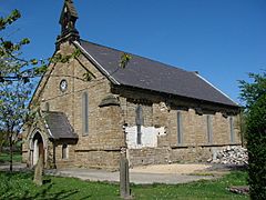
 Holy Trinity Church, Wingate |
|
| Population | 4,168 (2011 census) |
| OS grid reference | NZ400379 |
| Unitary authority |
|
| Ceremonial county | |
| Region | |
| Country | England |
| Sovereign state | United Kingdom |
| Post town | WINGATE |
| Postcode district | TS28 |
| Dialling code | 01429 |
| Police | Durham |
| Fire | County Durham and Darlington |
| Ambulance | North East |
| EU Parliament | North East England |
| UK Parliament |
|
Wingate is a village located in County Durham, England. It was once a "pit village," meaning it grew up around a coal mine. Before coal was found, only about 30 farmers lived here.
Wingate is in the eastern part of County Durham. It is about three miles southwest of Peterlee and seven miles northwest of Hartlepool. Like many villages in this area, Wingate grew very quickly when coal mining became important.
The name Wingate comes from old Anglo-Saxon words. Windig means "windy" and geat means "road." So, Wingate means "windy road." People in Wingate sometimes speak a special local way. It is called the pitmatic dialect. This dialect mixes sounds from nearby areas.
Contents
A Look Back: Wingate's History
People did not live in Wingate until the 1500s. But in the 1800s, mining changed everything. Wingate became a large village and an important local center. The village you see today is about two miles east of the original settlement. That older place is now called Old Wingate.
When Coal Changed Everything
Coal was discovered in Wingate in 1839. Workers dug two deep shafts to reach the coal. They started bringing coal out in December of that year. Mining was a big part of life here. Sadly, in 1906, an explosion in the mine killed 26 workers. In 2006, people marched to remember these miners.
The Plane Crash of 1971
On January 7, 1971, an Avro Vulcan bomber plane, called XM610, crashed near the school. The plane had an engine fire. The pilot stayed in the burning plane. He tried to steer it towards the sea. This was to keep it from crashing into the village. But the plane spiraled down and crashed in Wingate. It left a large hole in the ground. Luckily, no one on the ground was hurt. The pilot was given an award, the AFC, for trying to save the plane.
Famous People from Wingate
Wingate is also the birthplace of Ted Harrison. He was a Canadian artist. He was well-known for his paintings of the Yukon region.
How Wingate is Governed
Wingate is part of an "electoral ward." This is an area used for local elections. This ward also includes parts of Peterlee. In 2011, about 10,302 people lived in this ward.
Getting Around Wingate
Travel by Car
Wingate has good roads for people who drive to work or other places. The A181 road goes west to Durham. From Durham, you can get on the A1. The A1 is a major road that goes north and south. If you head east towards the coast, you will find the A19. This road connects to places like Peterlee, Sunderland, and Teesside. The main road through Wingate village is the B1280.
Public Transportation
Buses are available for public transport. Arriva North East runs services 58 and X22. Go North East runs service 239. These buses go to many places. You can travel to Sedgefield, Durham, Hartlepool, Middlesbrough, Peterlee, and Stockton-on-Tees.
Wingate used to have two train stations. They were called Wingate and Wellfield. These stations are now closed. Most of the old railway lines are now walking paths. One of these is the Hart to Haswell Walkway. You can still see one of the old level crossing gates. It is next to the Railway Crossings pub on Front Street.
 | Janet Taylor Pickett |
 | Synthia Saint James |
 | Howardena Pindell |
 | Faith Ringgold |


