Wolfeboro (CDP), New Hampshire facts for kids
Quick facts for kids
Wolfeboro, New Hampshire
|
|
|---|---|

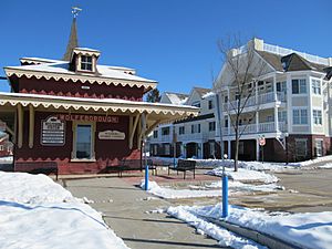
The former Wolfeboro Railroad station in the center of Wolfeboro village
|
|
| Country | United States |
| State | New Hampshire |
| County | Carroll |
| Town | Wolfeboro |
| Area | |
| • Total | 8.19 sq mi (21.21 km2) |
| • Land | 7.86 sq mi (20.36 km2) |
| • Water | 0.33 sq mi (0.85 km2) |
| Elevation | 545 ft (166 m) |
| Population
(2020)
|
|
| • Total | 3,300 |
| • Density | 419.79/sq mi (162.08/km2) |
| Time zone | UTC-5 (Eastern (EST)) |
| • Summer (DST) | UTC-4 (EDT) |
| ZIP code |
03894 (Wolfeboro)
03896 (Wolfeboro Falls) |
| Area code(s) | 603 |
| FIPS code | 33-86340 |
| GNIS feature ID | 2378098 |
Wolfeboro is a special kind of area called a census-designated place (CDP). It is located in the town of Wolfeboro in Carroll County, New Hampshire, United States. This CDP includes the main village of Wolfeboro and a smaller village called Wolfeboro Falls.
In 2020, about 3,300 people lived in the Wolfeboro CDP. The entire town of Wolfeboro had a population of 6,416 people.
Contents
Exploring Wolfeboro's Location and Surroundings
Wolfeboro CDP is in the southern part of the larger town of Wolfeboro. It sits between two beautiful lakes: Lake Winnipesaukee to the south and Lake Wentworth to the northeast.
Main Roads and Highways in Wolfeboro
New Hampshire Route 28 is the main road that goes through the village. It enters from the southeast as Tuftonboro Road and then turns northeast onto Center Street. This route can take you about 11 miles south to Alton or about 9 miles northeast to Ossipee.
New Hampshire Route 109 also comes into Wolfeboro village from the west on North Main Street. It then joins NH 28 and heads northeast on Center Street. NH 109 goes about 10 miles northwest to Melvin Village in the town of Tuftonboro. It also goes about 12 miles east to Sanbornville in the town of Wakefield.
Another road, New Hampshire Route 109A (Elm Street), starts from NH 28/109 in Wolfeboro Falls. It leads about 17 miles northwest to Moultonborough.
Understanding Wolfeboro's Borders
The Wolfeboro CDP has clear borders. To the south, it is next to Winter Harbor and Wolfeboro Bay, which are part of Lake Winnipesaukee. This border runs from Keewaydin Road in the west to a line between Sinclair Lane and Mountain West Drive in the east.
The eastern edge of the CDP follows Cross Road and Pleasant Valley Road northeast to Heath Brook. Then, it follows the brook northwest until it reaches Lake Wentworth. The CDP border then goes along the western shore of Lake Wentworth north to Hodges Road. From there, it follows Trotting Track Road west to Beach Pond Road and then south to NH 109A.
The western edge of the CDP is Waumbeck Road, from NH 109A south to a small brook just north of NH 109. It then follows this brook west to Keewaydin Road.
How Big is Wolfeboro?
The Wolfeboro CDP covers a total area of about 21.2 square kilometers (8.2 square miles). Most of this area, about 20.4 square kilometers (7.9 square miles), is land. The rest, about 0.9 square kilometers (0.3 square miles), is water. This means about 4% of the CDP's total area is water.
Who Lives in Wolfeboro? Population Facts
| Historical population | |||
|---|---|---|---|
| Census | Pop. | %± | |
| 1950 | 1,271 | — | |
| 1960 | 1,557 | 22.5% | |
| 1970 | 1,718 | 10.3% | |
| 1980 | 2,271 | 32.2% | |
| 1990 | 2,783 | 22.5% | |
| 2000 | 2,979 | 7.0% | |
| 2010 | 2,838 | −4.7% | |
| 2020 | 3,300 | 16.3% | |
| U.S. Decennial Census | |||
Let's look at the people who live in Wolfeboro. In 2010, there were 2,838 people living in the CDP. They lived in 1,353 households, and 795 of these were families. There were also 1,858 housing units, but 505 of them (about 27%) were empty. Many of these empty homes were used only during certain seasons or for vacations.
Diversity in Wolfeboro
Most of the people in Wolfeboro in 2010 were White (97.6%). A small number were African American (0.2%), Native American (0.2%), or Asian (0.7%). About 1.3% of the population identified as being from two or more races. About 1.5% of the people were Hispanic or Latino.
Households and Families
Out of all the households in 2010, about 19.6% had children under 18 living with them. Nearly half (47.6%) were married couples living together. About 7.9% had a female head of household with no husband present. The average household had 2.04 people, and the average family had 2.61 people.
Age Groups in Wolfeboro
The population in Wolfeboro has different age groups. In 2010, about 16.2% of the people were under 18 years old. About 32.2% were 65 years old or older. The average age of people in Wolfeboro was 54.0 years.
Income and Economy
From 2011 to 2015, the average yearly income for a household in Wolfeboro was estimated to be about $62,019. For families, the average income was about $69,091. The average income per person was $36,899. A small number of people, about 10.1% of the population and 4.8% of families, were living below the poverty line. This included about 11.1% of residents under 18 and 1.6% of those 65 or older.
See also
 In Spanish: Wolfeboro (condado de Carroll) para niños
 | Charles R. Drew |
 | Benjamin Banneker |
 | Jane C. Wright |
 | Roger Arliner Young |


