Yellow Bank River facts for kids
Quick facts for kids Yellow Bank River |
|
|---|---|

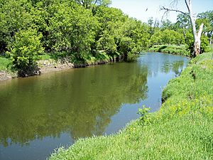
The Yellow Bank River in the Big Stone National Wildlife Refuge in 2007
|
|
 |
|
| Country | United States |
| State | South Dakota, Minnesota |
| Physical characteristics | |
| Main source | North Fork Yellow Bank River Round Lake, Coteau des Prairies, Codington County, South Dakota 1,838 ft (560 m) 45°06′57″N 96°55′00″W / 45.11583°N 96.91667°W |
| 2nd source | South Fork Yellow Bank River Coteau des Prairies, Deuel County, South Dakota 1,849 ft (564 m) 44°58′17″N 96°48′09″W / 44.97139°N 96.80250°W |
| River mouth | Minnesota River Agassiz Township, Lac qui Parle County, Minnesota 938 ft (286 m) 45°14′12″N 96°17′11″W / 45.23667°N 96.28639°W |
| Length | 12.0 mi (19.3 km) |
| Basin features | |
| Basin size | 460 sq mi (1,200 km2) |
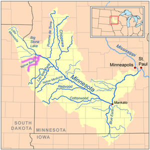
The Yellow Bank River is a river about 12 miles (19.3 km) long. It flows into the Minnesota River in western Minnesota, United States. This river is formed when two longer streams, the North Fork Yellow Bank River and the South Fork Yellow Bank River, join together. These streams also flow through northeastern South Dakota.
The Yellow Bank River is part of the Mississippi River's watershed. This means its water eventually flows into the Mississippi River. It drains an area of about 460 square miles (1,190 km²) in a farming region. The river got its name from the yellowish glacial drift found in the bluffs along its banks. In 1823, William H. Keating wrote that its name came from the Sioux language and meant "Spirit Mountain Creek." On an 1860 map of Minnesota, it was called "Yellow Earth River."
Contents
Where Does the Yellow Bank River Flow?
The Yellow Bank River has two main parts: a north fork and a south fork. Both of these start in South Dakota on the Coteau des Prairies. This is a high, hilly area that separates the waters flowing to the Mississippi River from those flowing to the Missouri River.
The North Fork's Journey
The North Fork Yellow Bank River begins at Round Lake, near South Shore, South Dakota. It flows east for about 57.3 miles (92.2 km). This fork travels through central Grant County, South Dakota before entering northwestern Lac qui Parle County, Minnesota.
The South Fork's Journey
The South Fork Yellow Bank River starts in northwestern Deuel County, South Dakota. This is about 6 miles (10 km) southwest of Strandburg, South Dakota. It generally flows northeast for about 56.4 miles (90.7 km). This fork goes through southern Grant County and western Lac qui Parle County, passing close to the town of Nassau, Minnesota.
Where the Forks Meet
The two forks join together in Yellow Bank Township, Minnesota. From this meeting point, the Yellow Bank River flows north for its short journey. It passes through the Big Stone National Wildlife Refuge. Finally, it enters the Minnesota River in Agassiz Township, Minnesota, about 3 miles (4.8 km) southeast of Odessa, Minnesota.
Nature Along the River
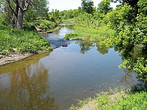
Inside the Big Stone National Wildlife Refuge, the river flows through woodlands. Here you can find trees like American elm, ash, box elder, and silver maple. People can also enjoy fishing in the river here.
How Much Water Flows in the River?
The United States Geological Survey measures the river's flow. They have a special station in Agassiz Township, south of Odessa. This spot is about 4.5 miles (7.2 km) upstream from where the river meets the Minnesota River.
Between 1940 and 2005, the river's average flow was 69.3 cubic feet per second (2 m³/s). This is like saying 69.3 cubic feet of water passed by every second. The highest flow ever recorded was on April 9, 1969, when it reached 6,940 cubic feet per second (197 m³/s). Sometimes, on many days over several years, the river's flow was recorded as zero. This means it was completely dry at those times.
 | Bayard Rustin |
 | Jeannette Carter |
 | Jeremiah A. Brown |


