Yorkshire, New York facts for kids
Quick facts for kids
Yorkshire, New York
|
|
|---|---|

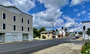
Main Street in the village of Delevan, July 2021
|
|
| Country | United States |
| State | New York |
| County | Cattaraugus |
| Government | |
| • Type | Town Council |
| Area | |
| • Total | 37.04 sq mi (95.94 km2) |
| • Land | 36.90 sq mi (95.56 km2) |
| • Water | 0.15 sq mi (0.38 km2) |
| Elevation | 1,697 ft (517 m) |
| Population
(2020)
|
|
| • Total | 3,840 |
| • Estimate
(2021)
|
3,808 |
| • Density | 102.13/sq mi (39.43/km2) |
| Time zone | Eastern (EST) |
| ZIP code | |
| FIPS code | 36-009-84055 |
Yorkshire is a small town located in Cattaraugus County, New York, United States. In 2020, about 3,840 people lived there. The town is found on the northern edge of the county.
Contents
Discovering Yorkshire's Past
The area that is now Yorkshire was first settled around 1810. The town of Yorkshire was officially created in 1820. It was formed from a larger area then known as the "town of Ischua," which is now called Franklinville.
In 1827, a part of Yorkshire was used to create another town called Machias.
Famous People from Yorkshire
Several notable people were born or lived in Yorkshire:
- Hiram M. Chittenden: Born in Yorkshire in 1858, he became a well-known historian of the American West. He was also an important engineer in the U.S. Army.
- Rodney R. Crowley: He served as the New York Inspector of State Prisons.
- Irving Stringham: A talented mathematician.
Yorkshire's Location and Landscape
Yorkshire covers an area of about 94.3 square kilometers (about 36.4 square miles). Most of this area is land, with a small part being water.
The northern border of the town follows Cattaraugus Creek. This creek also forms part of the border with Erie County. Part of the eastern border touches Wyoming County.
Roads and Routes
Two important roads meet and briefly join in Yorkshire:
- New York State Route 16: This road runs north and south.
- New York State Route 39: This road runs east and west.
Neighboring Towns
Yorkshire is surrounded by several other towns. If you imagine a clock, they are:
Population and Community Life
| Historical population | |||
|---|---|---|---|
| Census | Pop. | %± | |
| 1830 | 823 | — | |
| 1840 | 1,292 | 57.0% | |
| 1850 | 2,010 | 55.6% | |
| 1860 | 1,844 | −8.3% | |
| 1870 | 1,575 | −14.6% | |
| 1880 | 1,784 | 13.3% | |
| 1890 | 1,723 | −3.4% | |
| 1900 | 1,738 | 0.9% | |
| 1910 | 1,563 | −10.1% | |
| 1920 | 1,524 | −2.5% | |
| 1930 | 1,512 | −0.8% | |
| 1940 | 1,410 | −6.7% | |
| 1950 | 1,633 | 15.8% | |
| 1960 | 2,012 | 23.2% | |
| 1970 | 2,627 | 30.6% | |
| 1980 | 3,620 | 37.8% | |
| 1990 | 3,905 | 7.9% | |
| 2000 | 4,210 | 7.8% | |
| 2010 | 3,913 | −7.1% | |
| 2020 | 3,840 | −1.9% | |
| 2021 (est.) | 3,808 | −2.7% | |
| U.S. Decennial Census | |||
Over the years, the number of people living in Yorkshire has changed. The population has grown quite a bit since the early 1800s.
In 2000, there were 4,210 people living in Yorkshire. Most residents were White. A small number of people were from other racial backgrounds. About 0.59% of the population was of Hispanic or Latino origin.
Many households in Yorkshire are families. In 2000, about 33.5% of households had children under 18 living with them. The average household had about 2.52 people.
Places to See in Yorkshire
Yorkshire has several small communities and interesting spots:
- Delevan: This village is in the northeast part of the town. It's located south of Yorkshire village on NY Route 16.
- The Forks: This spot is near the northern town line, west of Yorkshire village.
- Lime Lake Outlet: This is a stream that flows north. It passes west of Delevan and empties into Cattaraugus Creek.
- McKinstrys Hollow: You can find this location in the south-central part of the town.
- Silliman's Corners: This area is near the northern town line, west of Yorkshire village.
- Yorkshire: This is a small community, or hamlet, located in the northeast corner of the town. It's also on NY Route 16, near Cattaraugus Creek.
See also
 In Spanish: Yorkshire (Nueva York) para niños


