
Zapata County, Texas facts for kids
Quick facts for kids
Zapata County
|
|
|---|---|

The front of the Zapata County Courthouse
|
|

Location within the U.S. state of Texas
|
|
 Texas's location within the U.S. |
|
| Country | |
| State | |
| Founded | January 22, 1858 |
| Named for | Colonel José Antonio de Zapata |
| Seat | Zapata |
| Largest community | Zapata |
| Area | |
| • Total | 1,058 sq mi (2,740 km2) |
| • Land | 998 sq mi (2,580 km2) |
| • Water | 60 sq mi (200 km2) 5.6% |
| Population
(2020)
|
|
| • Total | 13,889 |
| • Density | 13.128/sq mi (5.0686/km2) |
| Time zone | UTC−6 (Central) |
| • Summer (DST) | UTC−5 (CDT) |
| Congressional district | 28th |
Zapata County is a county in the state of Texas, USA. In 2020, about 13,889 people lived there. The main town and county seat is Zapata.
The county is located east of the Mexico–United States border. It is named after Colonel José Antonio de Zapata. He was a rancher who stood up against Mexico. Zapata County is also known as the Zapata, TX Micropolitan Statistical Area.
In the early 1920s, Zapata County was part of the Texas Oil Boom. Oil wells were drilled here thanks to Oliver Winfield Killam. He was an important businessman from Laredo.
Contents
Geography of Zapata County
Zapata County covers a total area of 1,058 square miles. About 998 square miles is land, and 60 square miles (5.6%) is water. The county is in the Rio Grande Valley. It sits on the edge of the Falcon International Reservoir.
Long ago, Zapata County was connected to Mexico by a bridge. This bridge was covered by water when the Falcon Dam and reservoir were built. Now, people can cross into Mexico using the Falcon Dam Port of Entry.
Main Roads in Zapata County
 U.S. Highway 83
 State Highway 16
Neighboring Areas
Zapata County shares borders with other counties and a city in Mexico:
- Webb County (to the north)
- Jim Hogg County (to the east)
- Starr County (to the southeast)
- Guerrero, Tamaulipas, Mexico (to the west)
Protected Natural Areas
Part of the Lower Rio Grande Valley National Wildlife Refuge is located in Zapata County. This area helps protect local wildlife.
People of Zapata County
The population of Zapata County has changed over time. Here's how many people lived there in different years:
| Historical population | |||
|---|---|---|---|
| Census | Pop. | %± | |
| 1860 | 1,248 | — | |
| 1870 | 1,488 | 19.2% | |
| 1880 | 3,636 | 144.4% | |
| 1890 | 3,562 | −2.0% | |
| 1900 | 4,760 | 33.6% | |
| 1910 | 3,809 | −20.0% | |
| 1920 | 2,929 | −23.1% | |
| 1930 | 2,867 | −2.1% | |
| 1940 | 3,916 | 36.6% | |
| 1950 | 4,405 | 12.5% | |
| 1960 | 4,393 | −0.3% | |
| 1970 | 4,352 | −0.9% | |
| 1980 | 6,628 | 52.3% | |
| 1990 | 9,279 | 40.0% | |
| 2000 | 12,182 | 31.3% | |
| 2010 | 14,018 | 15.1% | |
| 2020 | 13,889 | −0.9% | |
| U.S. Decennial Census 1850–2010 2010–2020 2020 |
|||
In 2020, there were 13,889 people living in Zapata County. There were 4,689 households and 3,254 families.
In 2000, the county had 12,182 people. About 43.20% of households had children under 18. Most households (64.20%) were married couples. The average household had 3.10 people.
The population was spread out by age:
- 33.00% were under 18 years old.
- 10.00% were from 18 to 24 years old.
- 24.10% were from 25 to 44 years old.
- 18.60% were from 45 to 64 years old.
- 14.30% were 65 years or older.
The average age was 31 years.
Most people in Zapata County identify as Hispanic or Latino. In 2020, about 93.59% of the population was Hispanic or Latino.
Regarding religion in 2020:
- 55% of people were Catholic.
- 5.8% were Evangelical Protestant.
- 2.4% were Mormon.
- 1.5% were Jehovah's Witnesses.
- 0.4% were Mainline Protestant.
- 35% belonged to other religions or no religion.
Education in Zapata County
All schools in Zapata County are part of the Zapata County Independent School District. Students who live here can attend Laredo Community College.
Communities in Zapata County
Zapata County does not have any official cities or towns with their own governments. Instead, it has several communities called "census-designated places." These are areas that the government counts for population, but they don't have their own city halls.
Census-Designated Places
- Falcon Lake Estates
- Falcon Mesa
- Las Palmas
- Lopeño
- Los Lobos
- Medina
- Morales-Sanchez
- New Falcon
- Ramireno
- San Ygnacio
- Siesta Shores
- Zapata (This is the county seat, where the main county offices are.)
Images for kids
-
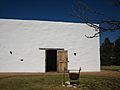
19th century Los Corralitos Building relocated from Zapata County to the National Ranching Heritage Center in Lubbock in West Texas
-
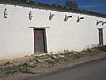
The western side of the Jesus Trevino Rancho building in the San Ygnacio Historic District; note the structural similarity to Los Corralitos Building
-
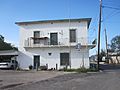
A two-story historic residence in San Ygnacio on U.S. Highway 83 business route
-
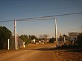
Entrance to Zapata County Cemetery from Farm-to-Market Road 496


See also
 In Spanish: Condado de Zapata para niños
