
1952 Kern County earthquake facts for kids
| UTC time | 1952-07-21 11:52:16 |
|---|---|
| ISC event | 893168 |
| USGS-ANSS | ComCat |
| Local date | July 21, 1952 |
| Local time | 4:52 am PDT |
| Magnitude | Mw 7.3 Ms 7.5 |
| Depth | 16 km (9.9 mi) |
| Epicenter | 34°52′N 119°06′W / 34.86°N 119.10°W |
| Fault | White Wolf Fault |
| Type | Oblique-slip |
| Areas affected | Southern California United States |
| Total damage | $70 million |
| Max. intensity | XI (Extreme) |
| Peak acceleration | ~ 1.0 g (est) |
| Casualties | 14 killed Hundreds injured |
The 1952 Kern County earthquake was a powerful earthquake that hit southern California on July 21, 1952. It happened in the San Joaquin Valley and measured 7.3 on the moment magnitude scale, which tells us how much energy an earthquake releases. The main shock struck at 4:52 AM Pacific Daylight Time.
This earthquake caused a lot of damage. It killed 12 people and injured hundreds more. The total cost of damage was about $60 million. Some areas, like near Bealville, felt an extreme shaking intensity, rated as XI on the Mercalli intensity scale. This scale describes how much people feel an earthquake and how much damage it causes.
The earthquake happened on the White Wolf Fault near Wheeler Ridge. It was the strongest earthquake in California since the famous 1906 San Francisco earthquake. The town of Tehachapi was hit the hardest, with the most deaths and damage. However, people felt the earthquake across central and southern California.
After the main earthquake, there were many smaller earthquakes called aftershocks. These continued through July and August. Many of these aftershocks were strong, with some reaching magnitude 5 or more. The strongest aftershock happened on August 22, measuring 5.8. It caused two more deaths and an extra $10 million in damage.
Scientists studied the area after the earthquake. They looked at how the ground moved and how much the earth shifted. The information they gathered from this earthquake helped set new standards for how scientists study future earthquakes. Even decades later, cities like Bakersfield were still working to make old buildings safer because of the damage from this earthquake.
Contents
Understanding Earthquakes in Kern County
What are Faults?
Earthquakes happen when large sections of the Earth's crust, called tectonic plates, suddenly move. These movements often occur along cracks in the Earth's crust called faults. California has many faults, including the famous San Andreas Fault.
Near where the 1952 earthquake happened, the San Andreas Fault meets another important fault called the Garlock Fault. The San Andreas Fault has caused many strong earthquakes in California. The Kern Canyon Fault is another fault in the area, but it's different from the White Wolf Fault that caused the 1952 earthquake.
Past Earthquakes in the Area
The 1952 earthquake was the first major earthquake to happen right within Kern County. Before this, other strong earthquakes were felt in the area, but they were usually far away. For example, the 1857 Fort Tejon earthquake was a very powerful quake that affected Fort Tejon, which is about 15 miles south of Wheeler Ridge.
The 1952 Kern County Earthquake
How the Ground Moved
The main earthquake, with a magnitude of 7.3, happened on the White Wolf Fault. This fault is a type of strike-slip fault, meaning the ground mostly moves sideways. However, it also had some "reverse slip," where one side of the fault moved up and over the other.
The earthquake's starting point, called the epicenter, was at the southwest end of the White Wolf Fault. Scientists found that the White Wolf Fault is curved. Different parts of the fault moved in slightly different ways. If earthquakes like this one happen regularly on this fault, it might be every 170 to 450 years.
Shaking Intensity
The shaking intensity was measured using the Mercalli scale. Most areas, especially Tehachapi and near the epicenter, felt a "Severe" intensity (VIII). But one place, southeast of Bealville, experienced "Extreme" intensity (XI).
At this location, a strong concrete railroad tunnel was badly cracked. The railroad tracks inside were twisted, and the tunnel entrance gap shrunk by up to 2.5 meters (about 8 feet). This extreme damage showed how powerful the shaking was in that specific spot.
Damage Caused by the Earthquake
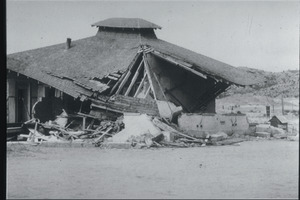
Even though the damage spread over a large area, the town of Tehachapi was hit the hardest. At least 11 people died there, and 35 were injured. An early report said the damage in Tehachapi alone was $2.6 million, affecting 700 families. Most buildings in the town were damaged. Fifteen homes were completely destroyed, 53 were heavily damaged, and 75 had lighter damage.
In Bakersfield, windows broke, and plaster fell from walls in homes and businesses. The county jail also suffered damage. Two railroad tunnels used by the Southern Pacific Railroad and the Santa Fe Railroad collapsed between Tehachapi and Marcel. Six other tunnels were also damaged. About 3.5 miles (5.6 km) of railroad track were twisted out of shape.
In Maricopa, southwest of Bakersfield, several buildings were so damaged they had to be torn down. These included the justice court, the Maricopa Hotel, and the post office. The small town of Taft had less damage, except for a destroyed wall at a J. C. Penney store and one damaged home.
Fires broke out at an oil refinery in Paloma and an explosion happened at a refinery in Long Beach due to a broken pipe. However, most of the Greater Los Angeles Area did not have heavy damage because the earthquake's center was far away. Power went out in Van Nuys and Los Angeles, and some windows broke in Long Beach. There were also large cracks in streets in Hollywood and a parking lot in Santa Ana.
Aftershocks: Shaking Continues
| Aftershocks (MMI ≥ VI (Strong)) | ||
| Mag | Date (UTC) | MMI |
|---|---|---|
| 5.1 ML | July 21 at 15:13 | VI |
| 5.7 Mw | July 23 at 00:38 | VI |
| 5.2 Mw | July 23 at 07:53 | VII |
| 5.8 Mw | July 23 at 13:17 | VII |
| 5.2 ML | July 23 at 18:13 | VI |
| 5.8 Mw | July 25 at 19:09 | VI |
| 5.9 Mw | July 25 at 19:43 | VI |
| 6.3 Mw | July 29 at 07:03 | VII |
| 5.5 Mw | July 31 at 12:09 | VI |
| 5.8 Mw | Aug 22 at 22:41 | VIII |
| Stover & Coffman 1993, pp. 86, 87, 144–147 | ||
After the main earthquake, scientists recorded 188 aftershocks stronger than magnitude 4.0. Six of these happened on the same day as the main shock and were magnitude 5 or higher. Some of these, like a magnitude 6.3 shock, were felt but did not cause much damage.
However, other aftershocks were very destructive. On July 23, a magnitude 5.2 aftershock caused more damage to buildings that were already weakened. It nearly destroyed a house that had only minor damage from the main earthquake. Gas and water pipes broke, and electrical transformers came loose. A magnitude 5.8 aftershock later that day made problems even worse in Tehachapi and Arvin.
Two aftershocks on July 25 caused damage to pipelines south of Bakersfield. They also caused minor building damage in several places. Landslides happened in some canyons and along California State Route 178. On July 29, another strong aftershock (intensity VII) started several fires and caused severe damage, especially to already weakened buildings in Bakersfield.
The strongest aftershock, a magnitude 5.8 event, occurred on August 22. It caused very heavy damage to brick buildings in Bakersfield. While only a few buildings completely collapsed, 90 out of 264 damaged buildings had to be torn down. This single aftershock caused an estimated $10 million in damage, injured several people, and led to two more deaths.
How the Ground Changed
The earthquake caused many cracks in the ground in the San Joaquin Valley. These cracks were not always clear and were caused by the shaking of the soft soil, not directly by the fault moving. Some cracks were wide, up to five inches, and showed that the ground had shifted sideways.
Scientists believed that the more significant ground breaks were directly caused by the fault moving deep underground. This was true in both the valley and the mountains. In some areas, the ground was pushed up, creating small hills called fault scarps. For example, near Comanche Creek, a fault scarp was raised about 3 feet (0.9 meters).
What Happened Next
Rebuilding Bakersfield
Downtown Bakersfield was severely affected by the earthquakes. Many damaged buildings were torn down to make way for new ones with modern designs. This happened during a time when the area was growing quickly after World War II. Important buildings like the Kern County Courthouse and the original Beale Memorial Clock Tower were either destroyed or rebuilt.
Some historic buildings that might have been saved were also torn down. However, some older buildings made of brick, called unreinforced masonry buildings, survived the earthquakes. It was often too expensive for owners to make these buildings safer. In 1993, the Bakersfield City Council was given the power to take over or tear down these unsafe buildings. Later, the city changed its approach because owners complained about the high costs.
Learning from the Earthquake
After big earthquakes today, teams of scientists and engineers go to the affected areas. They set up instruments to record ground movement and study the damage. This wasn't always done, but a detailed report written after the 1952 earthquake helped create a model for how these studies are done today.
The information gathered from the 1952 earthquake, along with data from the 1940 El Centro earthquake, was the most important data for studying strong ground motion until the 1971 San Fernando earthquake. This shows how much scientists learned from the Kern County earthquake.
Images for kids
-
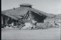
A collapsed school in Kern County, California
