2010 Moca earthquake facts for kids
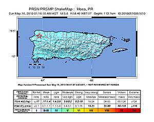
| UTC time | 2010-05-16 05:16:10 |
|---|---|
| USGS-ANSS | ComCat |
| Local date | May 16, 2010 |
| Local time | 01:16:10 |
| Magnitude | Mw 5.8 |
| Depth | 113.0 km (70 mi) |
| Epicenter | 18°24′00″N 67°04′12″W / 18.400°N 67.070°W |
| Fault | Cerro Goden fault zone (CGfz) |
| Type | Strike-slip |
| Areas affected | Puerto Rico |
| Total damage | Limited, localized. |
| Max. intensity | VI (Strong) |
| Tsunami | None |
| Casualties | None |
The 2010 Moca earthquake happened on May 16, 2010, at 1:16 a.m. local time in Moca, Puerto Rico. It is also known as the 2010 Puerto Rico earthquake. This earthquake measured 5.8 on the moment magnitude scale, which tells us how much energy was released. It also had a maximum Mercalli intensity of VI, meaning it was felt as Strong shaking.
This was the biggest earthquake to hit Puerto Rico since 1943. That earlier earthquake was much stronger, measuring 7.7. The 2010 Moca earthquake was special because its starting point, called the epicenter, was on land. Most earthquakes in this area happen under the ocean. Another earthquake with an epicenter on land happened later that year in Aguas Buenas.
Understanding the Moca Earthquake

The 2010 Moca earthquake started near the Cerro Goden fault zone. A fault zone is a crack in the Earth's crust where rocks move past each other. This fault zone runs across Puerto Rico from the northwest to the southwest. The earthquake's epicenter was about 4 miles east of Moca Pueblo. This is about 60 miles west of San Juan. Even though the earthquake was not huge, many people felt it strongly because it happened on land.
Where the Shaking Was Felt
The strongest shaking was felt in Moca, Añasco, Hormigueros, Lares, Ponce, and Salinas. People across the entire island of Puerto Rico felt the shaking. It was also felt on the nearby islands of Vieques and Culebra. Even people in the United States Virgin Islands and the Dominican Republic felt it.
After the main earthquake, there was at least one smaller earthquake, called an aftershock. This aftershock measured 3.2 on the Richter scale. Other small earthquakes reported later were not related to the Moca event. They happened in a different fault zone. Because the Moca earthquake happened on land and was not extremely large, it did not cause a tsunami.
Damage Caused by the Earthquake
The earthquake caused some damage, mostly in the mountainous areas. There were reports of landslides, which are when large amounts of earth and rock slide down a slope. A big landslide happened between Lares and Utuado, blocking Highway PR-111.
Buildings and other structures in Vega Baja and Florida also had some damage. Cracks appeared in buildings in Florida, Lares, Moca, and Vega Baja. In San Juan, tall buildings swayed during the shaking. Some homes in Utuado even moved about four inches off their foundations.
 | May Edward Chinn |
 | Rebecca Cole |
 | Alexa Canady |
 | Dorothy Lavinia Brown |

