Quick facts for kids
2011 Pacific typhoon season
 |
| Season summary map |
| First storm formed |
April 1, 2011 |
| Last storm dissipated |
January 1, 2012 |
| Strongest storm |
Songda – 920 hPa (mbar), 195 km/h (120 mph) (10-minute sustained) |
| Tropical depressions |
39 |
| Total storms |
21 |
| Typhoons |
8 |
| Super typhoons |
4 (Unofficial) |
| Total fatalities |
3,111 total |
| Total damage |
$7.18 billion (2011 USD) |
Pacific typhoon seasons
2009, 2010, 2011, 2012, 2013 |
| Related article |
- Timeline of the 2011 Pacific typhoon season
|
The 2011 Pacific typhoon season was a time when many tropical cyclones formed in the Western Pacific Ocean. Most of these storms happened between May and November. This article focuses on the Pacific Ocean north of the equator, between 100°E and 180°.
In this part of the world, two main groups give names to tropical cyclones. This means a storm can sometimes have two names! The Japan Meteorological Agency (JMA) names a storm if its winds reach at least 65 km/h (40 mph).
The Philippine Atmospheric, Geophysical and Astronomical Services Administration (PAGASA) also names storms. They name any tropical cyclone that enters or forms in their special area. This is true even if the JMA has already named it. On average, about 27 storms form in this area each year.
How Experts Predict Storms
Weather experts try to guess how many tropical cyclones, tropical storms, and typhoons will form each season. They also try to predict how many will hit certain countries.
Forecasts from Universities
The Guy Carpenter Asia-Pacific Climate Impact Centre (GCACIC) at the City University of Hong Kong makes predictions. In 2011, they thought there would be about 31 tropical cyclones, 27 tropical storms, and 17 typhoons. They also predicted how many storms would hit places like China, Korea, and Japan.
Another group, the Tropical Storm Risk Consortium (TSR) from University College London, also made forecasts. They predicted that the 2011 season would be about average. They expected around 28 tropical storms, 18 typhoons, and 8 very strong typhoons.
Predictions from Weather Services
Different weather services also shared their predictions:
- The PAGASA expected 20 to 22 tropical cyclones in their area.
- The Hong Kong Observatory thought 6 to 9 tropical cyclones would affect Hong Kong.
- The Thai Meteorological Department predicted 2 tropical storms would affect Thailand.
- Taiwan's Central Weather Bureau expected 22 to 26 tropical storms in the Western Pacific. They thought 3 to 5 of these would affect Taiwan.
Summary of the Season
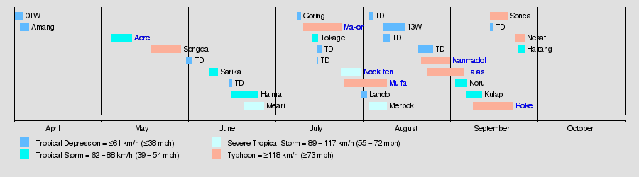
Major Storms of 2011
Here are some of the important storms that happened during the 2011 Pacific typhoon season.
Tropical Depression 01W
| Tropical depression (JMA) |
| Tropical depression (SSHS) |
|
|
| Duration |
April 1 – April 4 |
| Intensity |
55 km/h (35 mph) (10-min), 1004 mbar (hPa) |
This storm started as a low-pressure area over the South China Sea on April 1. The JMA quickly called it a tropical depression. However, strong winds in the upper atmosphere stopped it from getting stronger. It faded away by April 4.
Tropical Depression Amang
| Tropical depression (JMA) |
| Tropical depression (SSHS) |
|
|
| Duration |
April 3 – April 6 |
| Intensity |
55 km/h (35 mph) (10-min), 1000 mbar (hPa) |
Amang formed near Yap on April 3. PAGASA named it "Amang" as it moved into their area. It briefly became Tropical Depression 02W. But it soon weakened due to a weather front and cooler waters. Warnings were issued for some islands, but the storm disappeared by April 6.
Tropical Storm Aere (Bebeng)
| Tropical storm (JMA) |
| Tropical storm (SSHS) |
|
|
| Duration |
May 5 – May 12 |
| Intensity |
75 km/h (45 mph) (10-min), 992 mbar (hPa) |
Aere started near Palau on May 4 and quickly grew stronger. PAGASA named it "Bebeng." The JMA named it "Aere" when it became a tropical storm. It moved towards the Philippines. The storm caused widespread flooding and landslides. At least 35 people died, and damages reached about US$31.7 million.
Typhoon Songda (Chedeng)
| Typhoon (JMA) |
| Category 5 super typhoon (SSHS) |
|
|
| Duration |
May 19 – May 29 |
| Intensity |
195 km/h (120 mph) (10-min), 920 mbar (hPa) |
Songda formed on May 19 and quickly became a powerful typhoon. PAGASA named it "Chedeng." It reached Category 5 strength, making it very strong. Songda brought heavy rains to the Philippines, causing floods and landslides. Four people died there. In Okinawa, Japan, winds reached 198 km/h (123 mph). This caused about $287 million in damage. As it moved over Japan, it caused more flooding, leading to 13 deaths. About 400,000 people had to leave their homes near Tokyo.
Tropical Depression (May 31)
| Tropical depression (JMA) |
|
|
| Duration |
May 31 – June 2 |
| Intensity |
<55 km/h (35 mph) (10-min), 1004 mbar (hPa) |
This tropical depression formed southwest of Hong Kong on May 31. It did not get stronger and faded away by June 2.
Tropical Storm Sarika (Dodong)
| Tropical storm (JMA) |
| Tropical storm (SSHS) |
|
|
| Duration |
June 8 – June 11 |
| Intensity |
75 km/h (45 mph) (10-min), 996 mbar (hPa) |
Sarika formed near Cebu City, Philippines, on June 8. PAGASA named it "Dodong." It became Tropical Storm Sarika and made landfall in Shantou, China. The storm caused 23 deaths in Xianning, China, and damages of about $248 million.
Tropical Depression (June 15)
| Tropical depression (JMA) |
|
|
| Duration |
June 15 – June 16 |
| Intensity |
<55 km/h (35 mph) (10-min), 1004 mbar (hPa) |
This storm formed west of Puerto Princesa, Palawan on June 15. It moved towards the South China Sea but weakened quickly. It dissipated after making landfall in Hong Kong on June 16.
Tropical Storm Haima (Egay)
| Tropical storm (JMA) |
| Tropical storm (SSHS) |
|
|
| Duration |
June 16 – June 25 |
| Intensity |
75 km/h (45 mph) (10-min), 985 mbar (hPa) |
Haima started southeast of Manila on June 15. PAGASA named it "Egay." It became Tropical Storm Haima and made landfall in Zhanjiang, China. Later, it moved inland over Vietnam and weakened.
Severe Tropical Storm Meari (Falcon)
| Severe tropical storm (JMA) |
| Tropical storm (SSHS) |
|
|
| Duration |
June 20 – June 27 |
| Intensity |
110 km/h (70 mph) (10-min), 975 mbar (hPa) |
Meari formed east of the Philippines on June 20. PAGASA named it "Falcon." It became Severe Tropical Storm Meari as it passed Okinawa, Japan. Meari caused flooding and landslides in South Korea, where at least nine people died. In North Korea, it destroyed homes and flooded crops.
Tropical Depression Goring
| Tropical depression (JMA) |
|
|
| Duration |
July 9 – July 10 |
| Intensity |
55 km/h (35 mph) (10-min), 1000 mbar (hPa) |
Goring formed east of Aurora, Philippines, on July 9. PAGASA named it "Goring." It moved towards Fujian, China, and weakened into a low-pressure area by July 10.
Typhoon Ma-on (Ineng)
| Typhoon (JMA) |
| Category 4 typhoon (SSHS) |
|
|
| Duration |
July 11 – July 24 |
| Intensity |
175 km/h (110 mph) (10-min), 935 mbar (hPa) |
Ma-on formed near Minamitorishima on July 11 and quickly became a typhoon. PAGASA named it "Ineng." It reached its strongest point on July 16. Ma-on affected Japan, making landfall in Tokushima and Wakayama. It weakened into an extratropical cyclone by July 24.
Tropical Storm Tokage (Hanna)
| Tropical storm (JMA) |
| Tropical depression (SSHS) |
|
|
| Duration |
July 14 – July 16 |
| Intensity |
65 km/h (40 mph) (10-min), 1000 mbar (hPa) |
Tokage formed northwest of Palau on July 14. The JMA named it "Tokage," and PAGASA named it "Hanna." It was absorbed by the stronger Typhoon Ma-on by July 16.
Severe Tropical Storm Nock-ten (Juaning)
| Severe tropical storm (JMA) |
| Category 1 typhoon (SSHS) |
|
|
| Duration |
July 24 – July 31 |
| Intensity |
95 km/h (60 mph) (10-min), 985 mbar (hPa) |
Nock-ten formed east of the Philippines on July 22. PAGASA named it "Juaning." It became a severe tropical storm and made landfall in northern Aurora, Philippines. The storm caused widespread flooding in the provinces of Albay and Camarines. Many flights were canceled, and 25 crew members of a fishing boat went missing. Nock-ten caused about $126 million in damages and led to 119 deaths.
Typhoon Muifa (Kabayan)
| Typhoon (JMA) |
| Category 5 super typhoon (SSHS) |
|
|
| Duration |
July 25 – August 9 |
| Intensity |
175 km/h (110 mph) (10-min), 930 mbar (hPa) |
Muifa formed southeast of Chuuk on July 23. PAGASA named it "Kabayan." It quickly grew into a Category 5 typhoon. Muifa caused heavy rains in Luzon and Metro Manila, leading to flooding. Two people died when their boat capsized. Government offices and schools were closed in affected areas. Muifa caused about $480 million in damages and led to 22 deaths.
Tropical Depression Lando
| Tropical depression (JMA) |
|
|
| Duration |
July 31 – August 2 |
| Intensity |
<55 km/h (35 mph) (10-min), 1002 mbar (hPa) |
Lando formed west of Guam on July 28. PAGASA named it "Lando." It was a weak tropical depression and dissipated by August 2 without reaching Luzon.
Severe Tropical Storm Merbok
| Severe tropical storm (JMA) |
| Category 1 typhoon (SSHS) |
|
|
| Duration |
August 3 – August 9 |
| Intensity |
100 km/h (65 mph) (10-min), 980 mbar (hPa) |
Merbok formed near Wake Island on August 3 and quickly became a tropical storm. It reached severe tropical storm strength. Merbok weakened due to strong winds and colder waters, becoming extratropical by August 9.
Typhoon Nanmadol (Mina)
| Typhoon (JMA) |
| Category 4 super typhoon (SSHS) |
|
|
| Duration |
August 21 – August 31 |
| Intensity |
195 km/h (120 mph) (10-min), 920 mbar (hPa) |
Nanmadol formed north of Palau on August 19. PAGASA named it "Mina." It quickly intensified into a typhoon and made landfall in Gonzaga, Cagayan, Philippines. Nanmadol caused landslides, and five people died. Two fishermen went missing. It then made landfall in Taiwan and China, weakening significantly. Nanmadol caused about $603 million in damages and led to 38 deaths.
Typhoon Talas
| Typhoon (JMA) |
| Tropical storm (SSHS) |
|
|
| Duration |
August 23 – September 5 |
| Intensity |
120 km/h (75 mph) (10-min), 965 mbar (hPa) |
Talas formed west of Guam on August 22. It slowly strengthened into a typhoon. Talas moved very slowly towards Japan, bringing strong winds and rain. It made landfall in Aki, Kōchi, Japan, and weakened. Talas caused about $600 million in damages and led to 59 deaths.
Tropical Storm Noru
| Tropical storm (JMA) |
| Tropical storm (SSHS) |
|
|
| Duration |
September 2 – September 6 |
| Intensity |
75 km/h (45 mph) (10-min), 990 mbar (hPa) |
Noru formed northeast of Guam on September 1. It became a tropical storm. Noru weakened as it moved over colder waters and experienced strong winds. It became an extratropical cyclone by September 6.
Tropical Storm Kulap (Nonoy)
| Tropical storm (JMA) |
| Tropical storm (SSHS) |
|
|
| Duration |
September 6 – September 11 |
| Intensity |
65 km/h (40 mph) (10-min), 1000 mbar (hPa) |
Kulap formed southeast of Okinawa on September 4. PAGASA named it "Nonoy." It became a tropical storm but weakened due to dry air and strong winds. It dissipated by September 11.
Typhoon Roke (Onyok)
| Typhoon (JMA) |
| Category 4 typhoon (SSHS) |
|
|
| Duration |
September 11 – September 22 |
| Intensity |
175 km/h (110 mph) (10-min), 940 mbar (hPa) |
Roke formed northeast of the Northern Mariana Islands on September 8. PAGASA named it "Onyok." It quickly became a very strong typhoon. Roke made landfall in Hamamatsu, Japan. It caused significant damage and led to 13 deaths. It became extratropical by September 22.
Typhoon Sonca
| Typhoon (JMA) |
| Category 2 typhoon (SSHS) |
|
|
| Duration |
September 14 – September 20 |
| Intensity |
130 km/h (80 mph) (10-min), 970 mbar (hPa) |
Sonca formed northeast of the Northern Mariana Islands on September 13. It became a typhoon. Sonca weakened over colder waters and became extratropical by September 20.
Typhoon Nesat (Pedring)
| Typhoon (JMA) |
| Category 4 typhoon (SSHS) |
|
|
| Duration |
September 23 – September 30 |
| Intensity |
150 km/h (90 mph) (10-min), 950 mbar (hPa) |
Nesat formed southeast of Palau on September 21. It quickly became a typhoon. This storm was still active at the time of the original report.
Tropical Storm Haitang
| Tropical storm (JMA) |
| Tropical storm (SSHS) |
|
|
| Duration |
September 24 – September 27 |
| Intensity |
65 km/h (40 mph) (10-min), 996 mbar (hPa) |
Haitang formed south of Hong Kong on September 21. It became a tropical storm east of Vietnam. This storm was still active at the time of the original report.
Typhoon Nalgae (Quiel)
| Typhoon (JMA) |
| Category 4 super typhoon (SSHS) |
|
|
| Duration |
September 26 – October 5 |
| Intensity |
175 km/h (110 mph) (10-min), 935 mbar (hPa) |
Nalgae formed northwest of Manila, Philippines, on September 26. PAGASA named it "Quiel." It grew into a Category 4 super typhoon before hitting Luzon. Nalgae caused less damage than expected, but still destroyed nearly 2,900 homes. At least 18 people died, and 7 were missing. Over a million people were affected. Total losses were about US$2.62 million.
Tropical Storm Banyan (Ramon)
| Tropical storm (JMA) |
| Tropical depression (SSHS) |
|
|
| Duration |
October 9 – October 16 |
| Intensity |
65 km/h (40 mph) (10-min), 1002 mbar (hPa) |
Banyan formed south of Guam on October 7. PAGASA named it "Ramon." It became a tropical storm and made landfall over Leyte, Philippines. Banyan brought heavy rains and widespread flooding. At least ten people died, and 75,632 people were affected.
Severe Tropical Storm Washi (Sendong)
| Severe tropical storm (JMA) |
| Tropical storm (SSHS) |
|
|
| Duration |
December 13 – December 19 |
| Intensity |
95 km/h (60 mph) (10-min), 992 mbar (hPa) |
Washi formed near Chuuk on December 11. The JTWC named it "27W," and PAGASA named it "Sendong." It became a severe tropical storm and made landfall in Surigao del Sur, Philippines. Washi caused terrible flash flooding, especially in Iligan and Cagayan de Oro cities. At least 1,268 people died, and 1,079 were missing. Over 674,000 people were affected. Many homes were destroyed or damaged.
Storm Names Used
In the Northwestern Pacific, two groups name tropical cyclones. This means a storm can have two names! The Japan Meteorological Agency (JMA) names storms that reach 65 km/h (40 mph) winds. The Philippine Atmospheric, Geophysical and Astronomical Services Administration (PAGASA) names storms that enter or form in their special area.
International Names
Tropical cyclones are named from a list by the JMA in Tokyo. Each of 14 countries or territories submitted 10 names. Here are the names used in 2011:
- Aere (1101)
- Songda (1102)
- Sarika (1103)
- Haima (1104)
- Meari (1105)
- Ma-on (1106)
|
- Tokage (1107)
- Nock-ten (1108)
- Muifa (1109)
- Merbok (1110)
- Nanmadol (1111)
- Talas (1112)
|
- Noru (1113)
- Kulap (1114)
- Roke (1115)
- Sonca (1116)
- Nesat (1117) (active)
- Haitang (1118) (active)
|
- Megi (unused)
- Banyan (unused)
- Washi (unused)
- Pakhar (unused)
- Sanvu (unused)
- Mawar (unused)
|
Philippine Names
PAGASA uses its own naming system for tropical cyclones in its area. They name tropical depressions that form there or any storm that moves into their area.
- Amang (02W)
- Bebeng (1101)
- Chedeng (1102)
- Dodong (1103)
- Egay (1104)
|
- Falcon (1105)
- Goring
- Hanna (1107)
- Ineng (1106)
- Juaning (1108)
|
- Kabayan (1109)
- Lando
- Mina (1111)
- Nonoy (1114)
- Onyok (1115)
|
- Pedring (1117) (active)
- Quiel (unused)
- Ramon (unused)
- Sendong (unused)
- Tisoy (unused)
|
- Ursula (unused)
- Viring (unused)
- Weng (unused)
- Yoyoy (unused)
- Zigzag (unused)
|
Extra Names if Needed
- Abe (unused)
- Berto (unused)
|
- Charo (unused)
- Dado (unused)
|
- Estoy (unused)
- Felion (unused)
|
- Gening (unused)
- Herman (unused)
|
- Irma (unused)
- Jaime (unused)
|
Retired Names
Some storm names are "retired" if they cause a lot of damage or deaths. This means they won't be used again.
- The name Washi was retired from the international list.
- PAGASA retired the names Bebeng, Juaning, Mina, Pedring, and Sendong. These names were retired because the storms caused a lot of damage or many people died in the Philippines.
Season's Impact
This table shows all the storms in the western Pacific during 2011. It lists their strength, how long they lasted, where they hit, and how many people died or how much damage they caused. All damage numbers are in US dollars for 2011.
| Storm Name |
Dates Active |
Peak Strength |
Peak Winds
(10-min) |
Pressure |
Areas Affected |
Damage
(USD) |
Deaths |
| 01W |
April 1 – 4 |
Tropical depression |
55 km/h (35 mph) |
1004 hPa |
None |
None |
None |
| 02W (Amang) |
April 3 – 6 |
Tropical depression |
55 km/h (35 mph) |
1000 hPa |
Northern Mariana Islands |
None |
None |
| Aere (Bebeng) |
May 5 – 12 |
Tropical storm |
75 km/h (45 mph) |
992 hPa |
Philippines, Japan |
$31,700,000 |
44 |
| Songda (Chedeng) |
May 19 – 29 |
Typhoon |
195 km/h (120 mph) |
920 hPa |
Micronesia, Philippines, Japan |
$287,300,000 |
17 |
| Tropical Depression |
May 31 – June 2 |
Tropical depression |
Unknown |
1004 hPa |
None |
None |
None |
| Sarika (Dodong) |
June 8 – 11 |
Tropical storm |
75 km/h (45 mph) |
996 hPa |
Philippines, China |
$248,000,000 |
29 |
| Tropical Depression |
June 15 – 16 |
Tropical depression |
Unknown |
1004 hPa |
None |
None |
None |
| Haima (Egay) |
June 16 – 25 |
Tropical storm |
75 km/h (45 mph) |
985 hPa |
Philippines, China, Vietnam, Laos |
$16,700,000 |
18 |
| Meari (Falcon) |
June 20 – 27 |
Severe tropical storm |
110 km/h (70 mph) |
970 hPa |
Philippines, Japan, China, South Korea, North Korea |
$1,240,000 |
11 |
| Goring |
July 9 – 10 |
Tropical depression |
55 km/h (35 mph) |
1000 hPa |
Japan, Taiwan |
None |
None |
| Ma-on (Ineng) |
July 11 – 24 |
Typhoon |
175 km/h (110 mph) |
935 hPa |
Northern Mariana Islands, Japan |
$27,778,796 |
5 |
| Tokage (Hanna) |
July 14 – 16 |
Tropical storm |
65 km/h (40 mph) |
1000 hPa |
None |
None |
None |
| Tropical Depression |
July 16 – 17 |
Tropical depression |
Unknown |
998 hPa |
China |
None |
None |
| Tropical Depression |
July 16 |
Tropical depression |
Unknown |
1002 hPa |
China |
None |
None |
| Nock-ten (Juaning) |
July 24 – 31 |
Severe tropical storm |
95 km/h (60 mph) |
985 hPa |
Philippines, China, Vietnam, Laos, Thailand |
$126,322,445 |
119 |
| Muifa (Kabayan) |
July 25 – August 9 |
Typhoon |
175 km/h (110 mph) |
930 hPa |
Micronesia, Philippines, Japan, China, South Korea, North Korea |
$480,000,000 |
22 |
| Lando |
July 31 – August 2 |
Tropical depression |
Unknown |
1002 hPa |
Philippines |
None |
None |
| Merbok |
August 3 – 9 |
Severe tropical storm |
100 km/h (65 mph) |
980 hPa |
None |
None |
None |
| Tropical Depression |
August 3 – 4 |
Tropical depression |
55 km/h (35 mph) |
1008 hPa |
None |
None |
None |
| 13W |
August 8 – 15 |
Tropical depression |
55 km/h (35 mph) |
1004 hPa |
None |
None |
None |
| Tropical Depression |
August 8 – 10 |
Tropical depression |
55 km/h (35 mph) |
1008 hPa |
None |
None |
None |
| Tropical Depression |
August 20 – 25 |
Tropical depression |
55 km/h (35 mph) |
1002 hPa |
None |
None |
None |
| Nanmadol (Mina) |
August 21 – 31 |
Typhoon |
195 km/h (120 mph) |
920 hPa |
Philippines, Taiwan, China |
$603,000,000 |
38 |
| Talas |
August 23 – September 5 |
Typhoon |
120 km/h (75 mph) |
965 hPa |
Japan |
$600,000,000 |
59 |
| Noru |
September 2 – 6 |
Tropical storm |
75 km/h (45 mph) |
990 hPa |
None |
None |
None |
| Kulap (Nonoy) |
September 6 – 11 |
Tropical storm |
65 km/h (40 mph) |
1000 hPa |
Japan, South Korea |
None |
None |
| Roke (Onyok) |
September 8 – 22 |
Typhoon |
175 km/h (110 mph) |
940 hPa |
Japan, Russia |
None |
13 |
| Sonca |
September 14 – 20 |
Typhoon |
130 km/h (80 mph) |
970 hPa |
None |
None |
None |
| Tropical Depression |
September 14 – 15 |
Tropical depression |
Unknown |
1002 hPa |
None |
None |
None |
| Nesat (Pedring) |
September 23 – Still active |
Typhoon |
130 km/h (80 mph) |
965 hPa |
Philippines |
None |
None |
| Haitang |
September 24 – Still active |
Tropical storm |
65 km/h (40 mph) |
996 hPa |
China, Vietnam |
None |
None |
| Season Totals |
| Total Depressions: 31 |
April 1 – currently active |
|
195 km/h (120 mph) |
920 hPa |
|
$2,421,500,000 |
351 |
Accumulated Cyclone Energy (ACE)
ACE is a way to measure how much power a typhoon has and for how long it lasts. Stronger and longer-lasting typhoons have higher ACE numbers. This measurement only includes tropical storms and stronger systems. Tropical depressions are not counted.
Related Pages
Images for kids
-
A developing tropical depression on August 20, which failed to be a tropical storm in its lifecycle