Special Area No. 2 facts for kids
Quick facts for kids
Special Area No. 2
|
|
|---|---|

Little Fish Lake Provincial Park
|
|

Location within Alberta
|
|
| Country | Canada |
| Province | Alberta |
| Planning region | Red Deer |
| Incorporated | April 7, 1959 |
| Area
(2021)
|
|
| • Land | 9,195.06 km2 (3,550.23 sq mi) |
| Population
(2021)
|
|
| • Total | 1,860 |
| • Density | 0.2/km2 (0.5/sq mi) |
| Time zone | UTC-7 (MST) |
| • Summer (DST) | UTC-6 (MDT) |
| Forward sortation area |
T0J
|
| Area code | 403, 587, 825 |
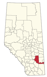
Special Area No. 2 is a unique part of Alberta, Canada. It's a large rural area in the southern part of the province. Unlike most places that have a local council elected by the people living there, Special Area No. 2 is managed by a group called the Special Areas Board. This board is made up of four people chosen by the government of Alberta. So, it's a bit like a municipal district, but with extra help and guidance from the province.
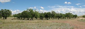
This area is home to some beautiful natural spots. It includes parts of two amazing provincial parks: Little Fish Lake Provincial Park and a section of the famous Dinosaur Provincial Park. You can also find several lakes here, such as Little Fish Lake, Dowling Lake, and the southern part of Sullivan Lake.
Exploring Special Area No. 2
Special Area No. 2 was officially formed on April 7, 1959. It covers a very large area of land, about 9,195 square kilometers (or about 3,550 square miles). Even though it's big, not many people live here, making it a very open and natural place.
Towns and Villages
While Special Area No. 2 is mostly rural, it surrounds a few towns and villages. These communities are important hubs for the people living in the area.
- Hanna is the main town. It's also where the office for the Special Areas Board is located.
- Empress is a village also surrounded by Special Area No. 2.
Hamlets and Localities
Inside Special Area No. 2, you'll find many smaller communities called hamlets and even tinier places known as localities. These are often small groups of homes or historic sites.
- Hamlets:
- Localities:
- Alness
- Atlee
- Batter Junction
- Berry Creek
- Bonar
- Bullpound
- Burfield
- Clivale
- Comet
- Dowling
- Finnegan
- Galarneauville
- Garden Plain
- Halliday
- Halsbury
- Howie
- Hutton
- Lawsonburg
- Lonebutte
- Lorne Crossing
- Majestic
- Medicine Hat Junction
- Millerfield
- Pollockville
- Sharrow
- Spondin
- Stoppington
- Taplow
- Trefoil
- West Wingham
Population Facts
Counting people helps us understand how communities are growing or changing.
In 2021, the population of Special Area No. 2 was 1,860 people. This number was a little bit lower than in 2016, when there were 1,905 people living there. Because the area is so big and the population is small, there are only about 0.2 people per square kilometer. This means there's a lot of open space!

