
Alto Malcantone facts for kids
Quick facts for kids
Alto Malcantone
|
||
|---|---|---|

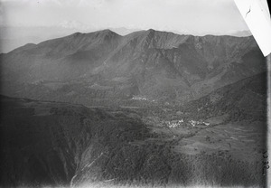
Arosio village
|
||
|
||

Alto Malcantone
Location in Switzerland

Alto Malcantone
Location in Canton of Ticino
|
||
| Country | Switzerland | |
| Canton | Ticino | |
| District | Lugano | |
| Area | ||
| • Total | 22.06 km2 (8.52 sq mi) | |
| Elevation | 810 m (2,660 ft) | |
| Population
(Dec 2020 )
|
||
| • Total | 1,380 | |
| • Density | 62.56/km2 (162.0/sq mi) | |
| Postal code |
6937-6939
|
|
| Surrounded by | Aranno, Bedano, Bioggio, Cademario, Curiglia con Monteviasco (IT-VA), Gambarogno, Gravesano, Manno, Miglieglia, Sigirino, Torricella-Taverne | |

Alto Malcantone is a small town, also called a municipality, located in the Lugano area of Ticino, a canton in Switzerland. It was created on March 13, 2005, by joining five smaller towns: Arosio, Breno, Fescoggia, Mugena, and Vezio.
Contents
- History of Alto Malcantone and Its Villages
- What is the Coat of Arms of Alto Malcantone?
- Geography of Alto Malcantone
- Who Lives in Alto Malcantone?
- How Has the Population Changed Over Time?
- Education in Alto Malcantone
- Economy and Jobs in Alto Malcantone
- Homes in Alto Malcantone
- Important Heritage Sites
- See also
History of Alto Malcantone and Its Villages
The area of Alto Malcantone has a long history. Each of its villages is very old, with the first mentions of them dating back hundreds of years. For example, Mugena was first written about in 1214, and Breno in 1140.
Arosio: An Ancient Crossroads
Arosio was an important place in the past. People believe a Roman road once passed through it. This road connected Ponte Tresa to Monte Ceneri Pass. In the Middle Ages, Arosio was a main town in its valley. Several villages, including Arosio, Breno, Mugena, and Vezio, worked together as one group.
The Church of San Michele in Arosio was first mentioned in 1217. It was rebuilt in the 1600s. Inside, you can see beautiful fresco paintings and fancy stucco decorations. Many skilled builders and architects from Arosio used to work all over Europe.
Long ago, people in Arosio made their living by farming and raising animals in the mountains. Today, most jobs are in the service industry. After 1960, many new homes were built in the village.
Breno: A Village with Roman Roots
Archaeologists have found items from the Roman times in Breno. The name "Breno" comes from an old Celtic language, but its exact meaning is not known. In the past, a religious group from Como owned land here, but the town bought its freedom in 1579.
The main church, S. Lorenzo, was built in 1233. It was rebuilt in 1596 and made bigger in 1852. Farmers in Breno used to move their animals between the valley and the lower hills for winter. This seasonal movement was common until the 1800s. Many construction workers from Breno also left to find jobs elsewhere. In the 1800s, the village built important places like a drawing school. Today, many people living in Breno travel to Lugano for work.
Fescoggia: A Village with Iron Mining
In 1296, Fescoggia was one of only two villages in the Lugano area that was fully owned by the Como Cathedral. A religious group also had the right to collect taxes here, but they sold it in 1579.
Fescoggia is part of the Breno church area. The Chapel of S. Silvester was built in the late 1200s. It was fixed up in the late 1700s. In the 1400s, the village also included mountain areas. People used to move their animals to mountain pastures in the east. In the 1800s, an hematite (iron ore) mine opened on Monte Torri. A furnace was built there to melt the iron. By 2000, most people living in Fescoggia traveled to other towns for work.
Mugena: A Place of Ancient Discoveries

An accidental find led to the discovery of an old Roman cremation cemetery in Mugena. In the Middle Ages, a church in Como owned land and rights in Mugena. Some old papers mention a "castrum," which might have been a supply camp. In the 1200s, Mugena was part of a group of villages that worked together.
The main church of S. Agata was first mentioned in 1361. It was rebuilt in the late 1600s. The church has beautiful stucco decorations from the 1700s. Mugena still looks like a rural village. In the past, farming and raising animals in the mountains were the main ways people earned money. Now, most people who live in Mugena work in Lugano.
Vezio: A Village of Builders
In the Early Middle Ages, the Bishop and a monastery in Como owned land and rights in Vezio. Vezio was part of the Breno church area until 1626. It became its own church area in 1684.
The church of St. Bartholomew was built in 1745. It was built on the site of an older building from 1444. Inside the church, you can see beautiful stucco work by artists from the Malcantone Valley. Until World War II, many construction workers from Vezio left to find jobs outside Switzerland. In the early 1900s, a small power plant was built near the village.
What is the Coat of Arms of Alto Malcantone?

In 2005, when Alto Malcantone was formed, it got a new coat of arms. A coat of arms is like a special symbol or logo for a town. The new design is a gold chestnut leaf on a blue background.
Chestnuts were a very important food in Ticino until the 1900s. This shows why the chestnut leaf is on the coat of arms.
Geography of Alto Malcantone
Alto Malcantone covers an area of about 21.92 square kilometers (about 8.46 square miles). A large part of this area, about 67.5%, is covered by forests. About 18.9% of the land is used for farming. Only a small part, 3.1%, has buildings or roads. The rest, about 10.4%, is land that cannot be used for farming or building.
Who Lives in Alto Malcantone?
Alto Malcantone has a population of about 1,294 people (as of 2008). About 6.3% of the people living here are from other countries. Over the last 10 years, the population has grown by about 16%.
Most people in Alto Malcantone speak Italian, which is 87.1% of the population. The second most common language is German (9.0%), and the third is French (2.2%).
In 2008, about 47.8% of the population were male and 52.2% were female. Most people living in Alto Malcantone are Swiss citizens.
Age Groups in Alto Malcantone
Looking at the age of people in 2009:
- About 10.3% of the population are children aged 0 to 9 years old.
- Another 10.3% are teenagers aged 10 to 19.
- Adults aged 20 to 59 make up about 52.8% of the population.
- People aged 60 and older make up about 26.6% of the population.
How Has the Population Changed Over Time?
The table below shows how the population of the different villages that now form Alto Malcantone has changed over many years.
| Year | Population Arosio |
Population Breno |
Population Fescoggia |
Population Mugena |
Population Vezio |
|---|---|---|---|---|---|
| 1599 | ca. 300 | - | - | 180 | - |
| 1692 | - | 521 | - | - | - |
| 1670 | - | - | - | - | 194 |
| 1801 | 221 | 459 | 131 | 108 | 171 |
| 1850 | 232 | 395 | 177 | 175 | 273 |
| 1900 | 186 | 398 | 149 | 157 | - |
| 1950 | 197 | 281 | 83 | 150 | - |
| 1990 | - | 197 | 105 | - | 171 |
| 2000 | 422 | 255 | 88 | 141 | - |
Education in Alto Malcantone
In Alto Malcantone, many adults (aged 25 to 64) have finished high school or gone on to higher education, like university. This is about 78.5% of the population.
In 2009, there were 182 students in Alto Malcantone. The education system in Ticino, where Alto Malcantone is located, offers different levels of schooling:
- Kindergarten: Children can attend up to three years of non-mandatory kindergarten.
- Primary School: This program lasts for five years. In Alto Malcantone, 66 students attended regular primary schools.
- Lower Secondary School: After primary school, students can choose different paths. Some go to a two-year middle school, and others go to a four-year program to get ready for higher education.
- Upper Secondary School: This level prepares students for a job or for university. Students might attend school while doing an internship or apprenticeship.
- Professional Programs: These programs last three years and train students for specific jobs like engineering or nursing.
Economy and Jobs in Alto Malcantone
In 2007, the unemployment rate in Alto Malcantone was about 3.16%, which means most people who wanted jobs had them.
Jobs are divided into three main types:
- Primary Sector: This includes jobs like farming and forestry. In 2005, 24 people worked in this sector.
- Secondary Sector: This includes jobs in manufacturing and construction. There were 41 people working in this sector.
- Tertiary Sector: This includes jobs in services, like shops, hotels, and offices. There were 61 people working in this sector.
Many people who work in Alto Malcantone use a private car to get to their jobs (70.6%). A smaller number (10.6%) use public transportation. In 2009, there were 2 hotels in Alto Malcantone.
Homes in Alto Malcantone
In 2000, the average home in Alto Malcantone had about 0.53 residents per room. This means there was plenty of space for people. A "room" is a living space of at least 4 square meters (about 43 square feet), like bedrooms, living rooms, and kitchens.
About 60.3% of the homes in Alto Malcantone were owned by the people living in them. This means they did not pay rent. In 2000, there were 501 private homes in the town, with an average of 2.2 people living in each home.
Important Heritage Sites
The Parish Church of Di S. Michele is a very important building in Alto Malcantone. It is listed as a Swiss heritage site of national significance. This means it is a special place that is protected because of its historical or cultural importance. The entire village of Breno is also recognized as an important heritage site.
|
See also
 In Spanish: Alto Malcantone para niños
