
Aniakchak National Monument and Preserve facts for kids
Quick facts for kids Aniakchak National Monument and Preserve |
|
|---|---|
|
IUCN Category V (Protected Landscape/Seascape)
|
|

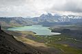
Aerial view of the caldera of Mount Aniakchak from the west
|
|

Aniakchak National Monument and Preserve
Location in Alaska
|
|
| Location | Lake and Peninsula Borough, Alaska, USA |
| Area | 601,294 acres (2,433.35 km2) |
| Created | December 1, 1978 |
| Visitors | 100 (in 2018) |
| Governing body | National Park Service |
| Website | Aniakchak National Monument and Preserve |
| Designated: | 1970 |
Aniakchak National Monument and Preserve is a special protected area in southwestern Alaska. It's home to the amazing Mount Aniakchak volcano, which is part of the Aleutian Range. This huge area, about 601,294 acres, is one of the least visited places in the entire U.S. National Park System. Why? Because it's super remote and the weather can be really tough!
The area was first declared a National Monument in 1978. Then, in 1980, it became both a National Monument and a Preserve. The Monument part covers about 137,176 acres, and the Preserve part is much larger, at 464,118 acres. Very few people visit Aniakchak each year, sometimes as few as 100! Most visitors try to fly into Surprise Lake, which is inside the volcano's crater. But thick fog and bad weather often make landing there very hard. You can also fly to a nearby village called Port Heiden and travel overland to the volcano.
The main part of the monument is the huge Aniakchak Crater, which is about 6 miles wide. The highest point on the rim of this crater is Aniakchak Peak. Inside the crater, you'll find Surprise Lake, which is where the Aniakchak River begins. Many smaller streams and rivers flow into Surprise Lake. Another cool feature inside the crater is Vent Mountain. This is where the volcano last erupted in 1931. The preserve lands are on either side of the monument. In the monument and preserve, local people can hunt for food (subsistence hunting). In the preserve, people can also hunt for sport. This wild region was mostly unknown until the 1920s, when explorers looking for oil found the volcano. A moderate eruption in 1931, which created Vent Mountain, brought a lot of attention to the area. This led to efforts to make it a national monument. Finally, in 1978, President Jimmy Carter officially made it a monument. The monument and preserve got their final boundaries in 1980.
Contents
Exploring Aniakchak: A Remote Adventure
Aniakchak National Monument and Preserve is located about 450 miles southwest of Anchorage, Alaska. It's on the Alaska Peninsula. You can't drive there by road, except for a rough path from Port Heiden that only reaches the outer edges of the volcano. The only ways to get into the monument are by floatplane to lakes like Surprise Lake, or by boat or plane to coastal towns. From there, you'd have to travel overland or by water.
The weather in Aniakchak is famous for being bad. This means your flights or boat trips might be delayed a lot. There are no buildings or staff permanently in the monument. The National Park Service doesn't even require visitors to sign in! Visitor help is available at the King Salmon Visitor Center in King Salmon, Alaska. This center is shared with other national parks like Lake Clark National Park and Katmai National Park and Preserve. The monument is next to the Alaska Peninsula National Wildlife Refuge. The monument covers about 137,000 acres, and the preserve covers about 465,000 acres.
What is the Aniakchak Crater Like?
The national monument is centered around the huge, 6-mile-wide crater of ancient Mount Aniakchak. This mountain was destroyed about 3,700 years ago when its top collapsed into its magma chamber. This event created the deep crater, which is about 3,300 feet deep. The highest point on the crater rim, Aniakchak Peak, is about 4,380 feet high. The lowest point inside the crater, where Surprise Lake begins, is about 1,055 feet high. The monument and preserve include this volcanic feature, the wild Aniakchak River, coastal areas along Bristol Bay, and parts of the Pacific Ocean coast.
Inside the Aniakchak crater, you'll find Surprise Lake and "the Gates." The Gates are a narrow opening in the crater rim where the Aniakchak River flows out of Surprise Lake towards the Pacific Ocean. Vent Mountain is also a key feature inside the crater.
The Aniakchak River flows for 30 miles to Aniakchak Bay on the coast. You can raft or kayak down it. The upper parts of the river drop quickly, sometimes 75 feet per mile, and narrow to just 15 feet wide. Further down, the river widens and winds through the landscape.
How Was Aniakchak Formed?
The monument and preserve have four main types of land. The center is the Aleutian Range mountains and Aniakchak Crater. The volcano's crater has active volcanic and hot spring areas, and Surprise Lake, which feeds the Aniakchak River. Around the mountains are river valleys shaped by glaciers. The coastline stretches for 52 miles along the southeastern side of the peninsula, facing the Pacific Ocean.
The mountains of the Aleutian Range are moderately tall, reaching up to 2,500 meters (about 8,200 feet). These mountain areas are mostly covered in tundra, a type of treeless plain. On top of these mountains are volcanoes, with Mount Aniakchak being the largest. Most of Mount Aniakchak has collapsed into its caldera (crater), and the floor of the caldera is about 1,100 feet above sea level. The caldera once held a large lake that covered about half of the crater. Eventually, the crater wall broke open, causing a huge flood as the lake drained. What's left of that lake is Surprise Lake, the source of the Aniakchak River.
The river valleys are different on each side. On the southeast side, the rivers drop steeply through volcanic ash. Plants are slowly growing back in these areas that were damaged by the volcano's eruptions. On the northwest side, the rivers flow more gently, and the land is marshy with lots of plants. The southeast coastal area has deep inlets, coastal cliffs, and islands. Three large bays are actually old volcanic craters. The two bigger ones are Aniakchak and Amber Bays, and the smaller one is Kejulik Bay. All of them have beaches covered in volcanic ash between the sea and large freshwater lagoons.
Wildlife and Nature in Aniakchak
The climate on the Alaska Peninsula is cool and wet. Storms from the Pacific Ocean bring a lot of rain, possibly over 100 inches each year along the coast, and even more in the mountains. The weather is usually cloudy and windy. This makes it hard for planes to fly and boats to travel, as visibility is low and waters are rough.
Aniakchak has both coastal and mountain environments, so it's home to many different plants and animals. Large land animals include caribou, Alaskan moose, brown bears, wolf packs, and wolverines. In the ocean, you might see harbor seals, sea lions, and sea otters. The 1931 volcanic eruption at Vent Mountain changed the plant life around the volcano. Scientists are now studying how these plant communities are recovering.
Aniakchak's Past: A Look Back
Scientists are just starting to learn about the ancient history of the Aniakchak area through recent archaeological studies. Today, the native people living here believe they are of Aleut ancestry. However, language studies suggest they are related to the Alutiiq people, who are part of the Yup'ik group. We don't know exactly when Alutiiq-speaking people first arrived.
Archaeological findings show that the central Alaska Peninsula was settled, abandoned, and re-settled many times. This might have happened because of big volcanic eruptions and the changes they caused to the environment. We don't know anything about the people who lived in the area before the huge Aniakchak volcano eruption 3,700 years ago. But since there's proof of people living nearby before that eruption, it's likely Aniakchak was also inhabited. However, the eruption completely changed the landscape, probably burying any old evidence of human activity under layers of volcanic ash. Areas closest to the volcano were mostly empty for thousands of years. The Pacific Coast was re-settled around 2,000 years ago, and the Meshik River area about 1,700 years ago. We don't know who these new settlers were, but it's possible different groups of people moved into the area at different times.
Early Explorers and Industries
Russian explorers came to Alaska in the mid-1700s, followed by fur traders who wanted to hunt sea otters. The first time the Aniakchak region was mentioned was in an atlas from 1827. The Russian Navy mapped the coast in 1831, with more expeditions in the 1840s. For the rest of the 1800s, few people visited the area, except for some fur trappers who didn't do very well.
The salmon fishing industry grew in Alaska, and a cannery was built in Chignik Lagoon in 1882, about 50 miles southwest of Aniakchak. Fishing traps were set up in Aniakchak Bay by 1917 and continued until 1949. The Alaska Packers' Association built a bunkhouse in the 1920s to house workers who maintained the traps and caught fish in the summer. At the same time, more fur trappers came to collect furs from land animals.
In the 1920s, there were reports of oil seeping out of the ground on the peninsula, which led to oil exploration. But detailed surveys showed there was no oil, and the area was mostly made of volcanic rock. This ended the oil search. However, these reports interested the U.S. Geological Survey (USGS). In 1922 and 1925, USGS teams surveyed the region. These surveys gave the first detailed descriptions of what they called an "extinct volcano." But in May 1931, Half Cone, a small volcano inside the caldera, erupted. Ash fell as far as 300 miles away!
Father Hubbard's Adventures
Father Bernard R. Hubbard was a Jesuit priest and a geology professor. He explored Alaska's volcanoes and glaciers every summer since 1927, writing popular books and articles for magazines like National Geographic. He first visited Aniakchak in 1930. Hubbard and his team boated up the Aniakchak River and explored the crater, finding hot vents (fumaroles). They returned in 1931 and saw the aftermath of the May eruption. In 1932, Hubbard and a pilot landed on Surprise Lake inside the caldera. Hubbard's exciting descriptions of the area appeared in the New York Times and made Aniakchak famous.
His stories caught the attention of National Park Service leaders, who started working to make Aniakchak a national monument. After some changes to the proposed boundary, the plan was put aside for a while to focus on expanding Katmai National Monument.
In 1932, people found many razor clams in Aniakchak Bay. A cannery was built, but the clams were quickly used up. Over the next few decades, the area became mostly empty, visited only by trappers and fishermen. In the 1960s, sport hunters started coming to hunt bear and caribou.
Becoming a National Monument
Interest in protecting Aniakchak grew again in the 1960s. In 1964, a study recommended protecting Aniakchak. In 1970, the Aniakchak caldera was named a National Natural Landmark. In 1971, a law called the Alaska Native Claims Settlement Act (ANCSA) set up how federal lands in Alaska would be managed. The Park Service set aside about 740,200 acres around Mount Aniakchak in 1973. A larger plan for an Aniakchak Caldera National Recreation Area was proposed, but there was opposition from native groups and mining companies. So, a smaller plan for Aniakchak Caldera National Monument was created, which was close to its current size. At the same time, the Aniakchak River was suggested to be part of the National Wild and Scenic Rivers System.
The idea for a "national recreation area" was partly to allow sport hunting, which is usually not allowed in national monuments. A bill in 1977 suggested having a national monument in the core of the area (around the caldera) and a national preserve in nearby areas, where sport hunting would be allowed. By late 1978, the bill was stuck in Congress. With a deadline approaching, President Jimmy Carter used his power to act.
Aniakchak National Monument was officially declared on December 1, 1978, by President Carter. It covered about 380,000 acres. In 1980, the Alaska National Interest Lands Conservation Act (ANILCA) was finally passed. This law established Aniakchak as a national monument surrounded by a larger national preserve that reached the coast. Local residents can hunt for food in most areas of the monument. In the preserve, both subsistence and sport hunting are allowed. The most common animals hunted are moose and brown bear.
In 1989, the Exxon Valdez oil spill caused oil to reach the Aniakchak coast. About two-thirds of the 68 miles of coast were affected, though not heavily. Cleanup efforts continued into 1990.
Aniakchak has the fewest visitors of any national park unit in the United States that is open to the public. However, the actual number of people entering the area is probably higher. This is because subsistence hunters are not counted, and some commercial hunting guides operate in the preserve. The National Park Service manages Aniakchak through Katmai National Park.
Historic Places in Aniakchak
|
Aniakchak Bay Historic Landscape District
|
|
|
Location in Alaska
|
|
| Location | Aniakchak National Monument and Preserve |
|---|---|
| Nearest city | Chignik, Alaska |
| Area | 2,100 acres (850 ha) |
| NRHP reference No. | 97000016 |
| Added to NRHP | February 14, 1997 |
The Aniakchak Bay Historic Landscape District, also known as the Aniakchak Bay House Pits, is a historic area around the Aniakchak River. It stretches from the Aniakchak Crater all the way to Aniakchak Bay. This district was added to the National Register of Historic Places in 1997. The site includes an old cabin from the Columbia River Packers Association at the mouth of the river and the surrounding lands. There are 10 important historical sites here. Archaeological studies in the area have found proof that native people lived here for the last 2,000 years.
Images for kids
-
Surprise Lake within the Aniakchak Caldera.
-
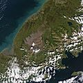
Natural-colour satellite image of Aniakchak National Monument and Preserve.


- Norris, Frank B. (1996) Isolated Paradise: An Administrative History of the Katmai and Aniakchak NPS Units, Alaska, National Park Service
- Ringsmuth, Katherine Johnson (2007) Beyond the Moon Crater Myth: A New History of the Aniakchak Landscape, National Park Service
See also
 In Spanish: Monumento nacional y Reserva de Aniakchak para niños
