
Antakya facts for kids
Quick facts for kids
Antakya
|
|||
|---|---|---|---|
|
Metropolitan municipality
|
|||
|
Clockwise from top: View overlooking Antakya, St. Paul Church, Habib-i Neccar Mosque, Church of Saint Peter, Antakya Ulu Mosque
|
|||
|
|||

Map showing Antakya District in Hatay Province
|
|||

Antakya
Location in Turkey
|
|||
| Area | |||
| • Total | 703 km2 (271 sq mi) | ||
| Elevation | 67 m (220 ft) | ||
| Population
(2022)
|
|||
| • Total | 399,045 | ||
| Area code(s) | 0326 | ||


.jpg)


Antakya is a city in Turkey. It is the capital of Hatay Province, which is the southernmost province of Turkey. The city is located in a green and fertile valley near the Orontes River. It is about 20 kilometers (12 miles) away from the Levantine Sea.
Antakya is also known as Antioch, its ancient name. It was founded a very long time ago, in the 4th century BC. It grew to be one of the biggest cities in the Roman Empire. Antioch was also a very important place for early Christianity. The New Testament says that the name "Christian" was first used here.
Over the centuries, Antakya was ruled by many different empires. These included the Byzantine Empire, the Rashidun Caliphate, the Seljuks, the Crusaders, the Mamluk Sultanate, and the Ottoman Empire. In 1939, it officially became part of the Turkish Republic.
On February 6, 2023, Antakya was hit very hard by two strong earthquakes. Many parts of the city were destroyed, and thousands of people lost their homes. Some historical places, like the Church of St Paul, were also ruined.
Contents
History of Antakya
Antakya has a very long and interesting history. People have lived in this area for thousands of years, even since the Stone Age.
Ancient Times in Antakya


The city of Antioch was founded in 300 BC by Seleucus I Nicator, one of the generals of Alexander the Great. It became a very important city for the Seleucid Empire, the Roman Empire, and the Byzantine Empire.
Antioch was a key city in the early days of Christianity. The Bible mentions Antioch as a place where early Christians gathered.
Antakya During the Middle Ages

In 637 AD, Antioch was taken by the Rashidun Caliphate. It became known as Antakiyah in Arabic. For many years, the city was on the border between different empires, which caused it to decline.
Later, in 969, the Byzantine Empire took the city back. But in 1084, the Seljuk Turks captured it.
The Crusader Era in Antakya


During the First Crusade, Christian armies from Europe attacked Antakya in 1097. After a long siege, they captured the city in 1098. This event caused a lot of damage and harm to the people living there.
Antakya then became the capital of a Crusader state called the Principality of Antioch. It stayed this way for almost 200 years.
In 1268, the city was captured by the Mamluk Sultanate from Egypt. After this, Antakya lost much of its importance because trade routes changed.
Antakya in Ottoman Times

In 1517, the Ottoman Empire took control of Antakya. The city was hit by big earthquakes in 1822 and 1872, which caused a lot of damage.
In 1835, the city had only about 5,000 people. There were hopes for a railway to help it grow, but this plan did not happen. The city also had problems with diseases like cholera because of poor sanitation. However, it later grew again when a railway was built.
French Mandate and Turkish Rule
After the Ottoman Empire fell, Antakya was part of an area controlled by France. In 1938, it became the Hatay State. Then, in 1939, it officially joined Turkey. This change caused many Christians and Alawites to move away from the city.
People and Languages in Antakya
In 1935, most of the people in Antakya were Turkish and Arab Muslims.
| Religion | Population (Percentage) |
|---|---|
| Sunni Muslims | 19,720 (58%) |
| Alawites | 8,670 (25.5%) |
| Christians | 4,930 (14.5%) |
| Others | 680 (2%) |
| Total | 34,000 (100%) |
Antakya was also home to a very old Jewish community for over 2,200 years. However, after the 2023 earthquake, the last Jewish person living in the city decided to leave.
Both Turkish and Arabic are still spoken in Antakya. The city has a mix of different faiths and groups living peacefully together. Most people are Muslim, but many follow the Alevi and Alawite traditions. There are also several small Christian communities in the city.
Modern Antakya

Antakya is built on hills, with the Mount Habib-i Neccar and old city walls. The city has grown a lot, with new areas built across the Orontes River. Four bridges connect the old and new parts of the city.
Antakya is an important city as a provincial capital. The area's economy has grown because of land development. The city is a busy place for shopping and business, with many restaurants and cinemas. People enjoy visiting the tea gardens and cafes in the Harbiye area.

Because it is close to the Syrian border, Antakya feels more diverse than some other Turkish cities. It has not seen as much migration from eastern Turkey as other cities.
Antakya is known in Turkey for its unique traditions and beliefs. Local crafts include soap made with bay tree oil.
.jpg)
2023 Earthquakes in Antakya

On February 6, 2023, Antakya was severely damaged by a major earthquake. Many parts of the city were completely destroyed. Over 1,200 buildings in the city center and nearby districts collapsed. Many historical sites, including churches and mosques, were ruined. The historic Antakya Synagogue and the Hatay State Assembly Building were also destroyed.
After the earthquake, officials promised to rebuild the affected areas quickly. However, months later, many damaged buildings were still standing, and survivors were living in tents. Reconstruction efforts are ongoing, with new apartment units being built in some areas.
Geography of Antakya
Antakya is located on the banks of the Orontes River, about 22 kilometers (14 miles) from the Mediterranean Sea. The city is in a valley surrounded by mountains. These include the Nur Mountains to the northwest and Mount Keldağ to the south. Mount Habib-i Neccar, which is 440 meters (1,440 feet) high, is to the east. The mountains provide green marble.
Antakya is located near the northern end of the Dead Sea Rift, which means it is prone to earthquakes.
The Amik Valley to the northeast of the city has very fertile soil. It is watered by the Orontes, Karasu, and Afrin rivers. A lake in the plain was drained in 1980 to create more farmland.
Neighborhoods of Antakya
Antakya District has 95 neighborhoods. Some of these include:
- Açıkdere
- Akasya
- Akçaova
- Akcurun
- Akevler
- Akhisar
- Aksaray
- Alaattin
- Alahan
- Alazı
- Altınçay
- Anayazı
- Apaydın
- Arpahan
- Aşağıoba
- Avsuyu
- Aydınlıkevler
- Bağrıyanık
- Barbaros
- Biniciler
- Bitiren
- Boşin
- Bozhüyük
- Büyükdalyan
- Cebrail
- Cumhuriyet
- Demirköprü
- Derince
- Dikmece
- Doğanköy
- Dutdibi
- Ekinci
- Emek
- Esenlik
- Esentepe
- Fevziçakmak
- Gazi
- Gazipaşa
- General Şükrü Kanatlı
- Gökçegöz
- Gülderen
- Güllübahçe
- Günyazı
- Güzelburç
- Habib-i Neccar
- Hacı Ömer Alpagot
- Haraparası
- Hasanlı
- Havuzlar
- İplik Pazarı
- Kantara
- Karaali
- Karaalibölüğü
- Kardeşler
- Karlısu
- Kisecik
- Kışla Saray
- Kocaabdi
- Küçükdalyan
- Kuruyer
- Kuyulu
- Kuzeytepe
- Madenboyu
- Mansurlu
- Maraşboğazı
- Maşuklu
- Melekli
- Meydan
- Narlıca
- Odabaşı
- Oğlakören
- Orhanlı
- Ovakent
- Paşaköy
- Saçaklı
- Saraycık
- Saraykent
- Şehitler
- Serinyol
- Şeyhali
- Şirince
- Sofular
- Suvatlı
- Tahtaköprü
- Tanışma
- Üçgedik
- Ulucami
- Ürgenpaşa
- Üzümdalı
- Uzunaliç
- Yaylacık
- Yenicami
- Yeşilova
- Zenginler
- Zülüflühan
Climate in Antakya
Antakya has a hot-summer Mediterranean climate. This means it has hot, dry summers and mild, wet winters. Because it is at a higher altitude, its temperatures can be a bit cooler than the coast.
- Highest recorded temperature: 45.2°C (113.4°F) on August 13, 2023
- Lowest recorded temperature: -11.8°C (10.8°F) on January 14, 1950
| Climate data for Antakya (1991–2020, extremes 1940–2023) | |||||||||||||
|---|---|---|---|---|---|---|---|---|---|---|---|---|---|
| Month | Jan | Feb | Mar | Apr | May | Jun | Jul | Aug | Sep | Oct | Nov | Dec | Year |
| Record high °C (°F) | 20.5 (68.9) |
26.6 (79.9) |
30.5 (86.9) |
37.5 (99.5) |
42.5 (108.5) |
43.2 (109.8) |
44.6 (112.3) |
45.2 (113.4) |
43.5 (110.3) |
39.2 (102.6) |
32.5 (90.5) |
25.1 (77.2) |
45.2 (113.4) |
| Mean daily maximum °C (°F) | 12.5 (54.5) |
14.9 (58.8) |
19.0 (66.2) |
23.0 (73.4) |
27.0 (80.6) |
29.7 (85.5) |
31.6 (88.9) |
32.5 (90.5) |
31.4 (88.5) |
28.2 (82.8) |
20.3 (68.5) |
13.9 (57.0) |
23.7 (74.7) |
| Daily mean °C (°F) | 8.2 (46.8) |
9.9 (49.8) |
13.6 (56.5) |
17.4 (63.3) |
21.6 (70.9) |
25.1 (77.2) |
27.6 (81.7) |
28.3 (82.9) |
26.1 (79.0) |
21.5 (70.7) |
14.3 (57.7) |
9.5 (49.1) |
18.6 (65.5) |
| Mean daily minimum °C (°F) | 5.0 (41.0) |
5.9 (42.6) |
9.1 (48.4) |
12.6 (54.7) |
16.9 (62.4) |
21.3 (70.3) |
24.4 (75.9) |
25.2 (77.4) |
21.7 (71.1) |
16.2 (61.2) |
9.8 (49.6) |
6.2 (43.2) |
14.5 (58.1) |
| Record low °C (°F) | −11.8 (10.8) |
−6.8 (19.8) |
−4.2 (24.4) |
1.5 (34.7) |
7.7 (45.9) |
11.6 (52.9) |
15.9 (60.6) |
15.4 (59.7) |
7.9 (46.2) |
2.3 (36.1) |
−3.0 (26.6) |
−6.6 (20.1) |
−11.8 (10.8) |
| Average precipitation mm (inches) | 198.4 (7.81) |
165.2 (6.50) |
142.9 (5.63) |
101.9 (4.01) |
80.9 (3.19) |
30.9 (1.22) |
16.0 (0.63) |
17.5 (0.69) |
41.6 (1.64) |
76.6 (3.02) |
99.6 (3.92) |
182.0 (7.17) |
1,154.2 (45.44) |
| Average precipitation days | 15.11 | 13.21 | 13.17 | 8.98 | 5.54 | 2.15 | 0.6 | 0.64 | 3.35 | 7.2 | 8.93 | 13.5 | 92.4 |
| Average relative humidity (%) | 74.0 | 69.9 | 67.4 | 67.1 | 66.7 | 67.3 | 69.7 | 69.9 | 66.0 | 64.0 | 66.5 | 74.8 | 68.6 |
| Mean monthly sunshine hours | 105.4 | 130.0 | 186.0 | 219.0 | 282.1 | 321.0 | 344.1 | 319.3 | 276.0 | 217.0 | 150.0 | 102.3 | 2,652.2 |
| Mean daily sunshine hours | 3.4 | 4.6 | 6.0 | 7.3 | 9.1 | 10.7 | 11.1 | 10.3 | 9.2 | 7.0 | 5.0 | 3.3 | 7.3 |
| Source 1: Turkish State Meteorological Service | |||||||||||||
| Source 2: NOAA (humidity) | |||||||||||||
Education in Antakya
Mustafa Kemal University, also known as MKU, is a large university in the region. It has many different departments, including Engineering and Medicine. The main campus is called Tayfur Sökmen and is located about 15 kilometers (9 miles) north of Antakya.
The university was started in 1992. Today, more than 32,000 students study there. MKU also has campuses in other districts of Hatay Province.
Main Sights to See in Antakya

Antakya has a rich history, which means there are many interesting places to visit.
- The Hatay Archaeology Museum has one of the world's largest collections of Roman mosaics.
- The Church of St Peter is carved into a rock. It has tunnels and is an important place for Christian visitors.
- The old market district, called Uzun Çarşı Caddesi, is in the city center. It has many traditional shops to explore.
- The waterfalls at the Harbiye / Daphne promenade are a beautiful natural sight.
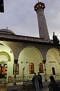
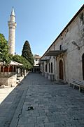
- The Ottoman Habib'i Neccar Mosque is the oldest mosque in Antakya.
- The narrow streets and old houses in Antakya's old town are fun to explore.
- The Vespasianus Titus Tunnel is about 35 kilometers (22 miles) from the city center.
- Bagras (Bakras) Castle is an ancient castle that was rebuilt many times. It was an important watchtower during the Crusades.
- You can get a great view of the city from the top of Mount Habib-i Neccar.
- St. Paul Orthodox Church is another important religious site.
Antakya is part of the European Association of Historic Towns and Regions because of its rich history and architecture. An old Roman bridge was destroyed in 1972 when the Orontes River was widened.

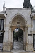
-
Antakya Yeni Camii Exterior
-
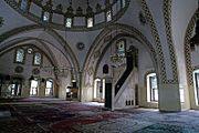
Antakya Habib-i Neccar Camii Interior
-
Antakya Habib-i Neccar Camii Exterior
-
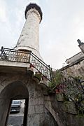
Antakya Sarimiye Mosque Minaret
-
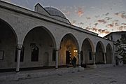
Antakya Ulu Cami Entrance to courtyard
-
Antakya Ulu Cami
-
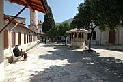
Antakya Ulu Cami
-
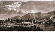
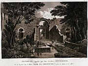
View of the river in the 1780s, by Louis-François Cassas.
-
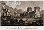
Medina gate in the 1780s, by Louis-François Cassas.
-
Ruins of the Seleucus palace in the 1780s, by Louis-François Cassas.
-
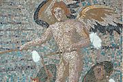
Mosaics of Eros are standing on the wings of two Psyches and whipping them on in Hatay Archaeology Museum
-
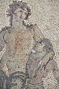
Dionysus mosaic in Hatay Archaeology Museum


.jpg)


Transportation in Antakya
The city is served by Hatay Airport, which connects it to other places.
Sports in Antakya
Antakya has a professional men's football club called Hatayspor. They play in the Süper Lig, which is a top league in Turkey.
There is also a professional women's football team, Hatay Büyükşehir Belediyesi. Additionally, the city has a women's basketball team, Hatay Büyükşehir Belediyespor, which plays in the Turkish Women's Basketball League.
Antakya Cuisine
The food in Antakya is very famous and delicious. It is considered Levantine food, which is common in the Eastern Mediterranean, rather than typical Turkish food. Many dishes use beef and lamb.
Some popular savory foods include:
- Kebab: Served with spices and onions in flatbread.
- Oruk and İçli köfte: These are deep-fried balls made of bulgur wheat stuffed with minced meat.
- Kaytaz böreği: A pastry made with wheat, beef, tomato, and onion.
- Katıklı ekmek: A flatbread with pepper paste, spices, and cheese. It's like an old version of pizza!
- Pomegranate syrup: Used as a salad dressing, it's called debes ramman.
- Semirsek: A thin bread filled with spicy pepper, minced meat, or spinach.
- Spicy chicken: A special dish from the Harbiye area.
- Za'atar (Zahter): A paste of spiced thyme, oregano, and sesame seeds mixed with olive oil, spread on flatbread.
- Fresh chick peas: Eaten as a snack.
- Meze (small dishes to share)
- Hummus: A dip made from chickpeas.
- Pureed fava beans.
- Patlıcan salatası or babaganoush: Made from baked and sliced eggplant mixed with pepper and tomato.
- Taratur: Made with walnuts, tahini, yogurt, and garlic.
- Süzme yoğurt: A thick type of yogurt.
- Ezme biber: Made from pepper and walnuts.
- Surke: Dried cheese curds served in spicy olive oil.
- Çökelek: A spicy, sun-dried cheese.
- Eels from the Orontes River: Spiced and fried in olive oil.
- Sweets and Desserts
- Künefe: A hot, sweet dessert made with cheese and shredded pastry. Antakya is known as the künefe capital of Turkey!
- Müşebbek: Rings of deep-fried pastry.
- Peynirli irmik helvası: A warm dessert made of semolina, sugar, and a special cheese.
Twin Towns of Antakya
Antakya is connected with other cities around the world. These are called twin towns or sister cities.
 Aalen, Germany (since 1995).
Notable People from Antakya
- Alexandros of Antioch (1st century BC): A Greek sculptor.
- Ignatius of Antioch: An early Christian leader.
- John Chrysostom (349–407): A famous Christian speaker.
- Saint Luke: A Christian evangelist and author of parts of the Bible.
- Tayfur Sökmen: The president of the Republic of Hatay from 1938 to 1939.
See also
 In Spanish: Antioquía para niños
