Apex, North Carolina facts for kids
Quick facts for kids
Apex
|
|||||
|---|---|---|---|---|---|

|
|||||
|
|||||
| Nickname(s):
Peak City
|
|||||
| Motto(s):
"The Peak of Good Living"
|
|||||

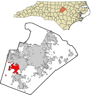
Location in Wake County and North Carolina
|
|||||
| Country | United States | ||||
| State | North Carolina | ||||
| County | Wake | ||||
| Incorporated | 1873 | ||||
| Named for | Highest point on the Chatham Railroad | ||||
| Government | |||||
| • Type | Council-Manager | ||||
| Area | |||||
| • Total | 25.15 sq mi (65.13 km2) | ||||
| • Land | 25.06 sq mi (64.90 km2) | ||||
| • Water | 0.09 sq mi (0.23 km2) 0.36% | ||||
| Elevation | 390 ft (120 m) | ||||
| Population
(2020)
|
|||||
| • Total | 58,780 | ||||
| • Estimate
(2023)
|
72,225 | ||||
| • Density | 2,345.66/sq mi (905.67/km2) | ||||
| Demonym(s) | Apexian or Apexer | ||||
| Time zone | UTC−5 (EST) | ||||
| • Summer (DST) | UTC−4 (EDT) | ||||
| ZIP codes |
27502, 27523, 27539
|
||||
| Area codes | 919, 984 | ||||
| FIPS code | 37-01520 | ||||
| GNIS feature ID | 2405157 | ||||
| Website | www.apexnc.org | ||||
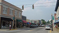
Apex (/ˈeɪ.pɛks/) is a town in Wake County, North Carolina, United States. It is known for its historic downtown area. This area was named a special historic district in 1994. The town's name comes from its location. It is the highest point on the old Chatham Railroad. This is why its motto is "The Peak of Good Living."
A small community grew around the railroad station in the late 1800s. Forests were cleared to create farms, many of which grew tobacco. Apex became a trading center because it was close to the state capital. The railroad helped ship products like lumber, tar, and tobacco. The town officially became a town in 1873. By 1900, about 349 people lived there. By the 2020 census, the population grew to 58,780. This made it the 17th-most populated town in North Carolina.
The town's population grew a lot in the late 1990s. This was partly because of the Research Triangle Park. This park, started in the 1960s, needed many technology workers. This demand helped Apex grow quickly.
Contents
- History of Apex: From Railroad Stop to Modern Town
- Geography and Climate
- People of Apex: Population and Diversity
- Economy: Jobs and Businesses in Apex
- Education: Schools in Apex
- Infrastructure: Getting Around and Services
- Parks and Recreation: Fun Things to Do
- Arts and Culture: Events and Places
- Notable People from Apex
- See Also
History of Apex: From Railroad Stop to Modern Town

How Apex Got Its Name
In 1869, the Chatham Railroad was finished. It connected Chatham County with Raleigh. At the highest point of this railway line, there was a pond. Railroad workers called this spot the "apex of the grade." Trains coming from Chatham would stop here to get more water. A community started to grow around this stop, and the workers called it Apex. The town of Apex officially became a town in 1873. The pond was later drained and was gone by 1900.
Growth and Challenges
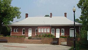
Apex grew slowly over the years. It faced several big fires, including one on June 12, 1911. This fire destroyed most of the downtown business area. But the town center was rebuilt. Today, it is one of the best-preserved railroad towns in North Carolina. The Apex Union Depot is at the heart of the town. It was once a passenger station for trains. Later, it housed the local library. Now, it is home to the Apex Chamber of Commerce.
Apex had some difficulties during the Great Depression. But it started growing strongly again in the 1950s. Being close to the Research Triangle Park (RTP) led to more homes being built. Even with this growth, Apex kept its small-town feel. In the 1990s, the town's population grew four times larger, reaching over 20,000 people. This put new demands on the town's services.
Apex has continued to grow in recent years. A large shopping center was built where Highway 55 and US 64 meet. Many new neighborhoods have also been built as the town expands west.
Important Events
In October 2006, there was a large event involving chemicals at a waste-processing facility. This caused a fire and led to over 16,000 residents being asked to leave their homes for safety. There were only a few minor injuries, and people could soon return. In 2009, a court approved a $7.85 million payment to help residents affected by the event. Each household received $750, and businesses received $2,200.
In 2015, Money magazine named Apex the number-one place to live in America.
Besides the Apex Union Depot, other important buildings are listed on the National Register of Historic Places. These include the Apex City Hall, the Apex Historic District, the Calvin Wray Lawrence House, and the Utley-Council House.
Geography and Climate
Location of Apex
Apex is a suburb of both Raleigh and Research Triangle Park (RTP). It is located southwest of Raleigh. You can reach it directly by US 1. Apex is south of RTP and has direct highway access via NC 540. The town is on the edge of two major river systems: the Neuse and Cape Fear Rivers.
The town covers about 25.15 square miles (65.13 km²). Most of this area, 25.06 square miles (64.90 km²), is land. A small part, 0.09 square miles (0.23 km²), is water. Nearby towns include Cary to the north and northeast, Holly Springs to the south, and Raleigh to the east and northeast.
Apex Weather
| Climate data for Apex, North Carolina, 1991–2020 normals, extremes 1993–present | |||||||||||||
|---|---|---|---|---|---|---|---|---|---|---|---|---|---|
| Month | Jan | Feb | Mar | Apr | May | Jun | Jul | Aug | Sep | Oct | Nov | Dec | Year |
| Record high °F (°C) | 80 (27) |
82 (28) |
89 (32) |
92 (33) |
96 (36) |
103 (39) |
103 (39) |
104 (40) |
100 (38) |
98 (37) |
87 (31) |
80 (27) |
104 (40) |
| Mean maximum °F (°C) | 69.5 (20.8) |
73.4 (23.0) |
81.6 (27.6) |
86.5 (30.3) |
90.1 (32.3) |
94.9 (34.9) |
96.5 (35.8) |
95.3 (35.2) |
92.3 (33.5) |
86.8 (30.4) |
77.2 (25.1) |
73.3 (22.9) |
98.2 (36.8) |
| Mean daily maximum °F (°C) | 50.9 (10.5) |
54.4 (12.4) |
61.9 (16.6) |
71.6 (22.0) |
78.7 (25.9) |
85.7 (29.8) |
89.0 (31.7) |
87.4 (30.8) |
81.5 (27.5) |
71.8 (22.1) |
62.2 (16.8) |
53.9 (12.2) |
70.7 (21.5) |
| Daily mean °F (°C) | 40.9 (4.9) |
43.5 (6.4) |
50.5 (10.3) |
59.6 (15.3) |
67.7 (19.8) |
75.4 (24.1) |
79.2 (26.2) |
77.5 (25.3) |
71.6 (22.0) |
60.7 (15.9) |
50.9 (10.5) |
44.0 (6.7) |
60.1 (15.6) |
| Mean daily minimum °F (°C) | 30.9 (−0.6) |
32.6 (0.3) |
39.1 (3.9) |
47.6 (8.7) |
56.7 (13.7) |
65.2 (18.4) |
69.4 (20.8) |
67.7 (19.8) |
61.7 (16.5) |
49.5 (9.7) |
39.5 (4.2) |
34.1 (1.2) |
49.5 (9.7) |
| Mean minimum °F (°C) | 15.6 (−9.1) |
18.5 (−7.5) |
24.8 (−4.0) |
33.9 (1.1) |
44.1 (6.7) |
57.1 (13.9) |
61.9 (16.6) |
61.3 (16.3) |
52.3 (11.3) |
36.9 (2.7) |
26.3 (−3.2) |
23.1 (−4.9) |
14.3 (−9.8) |
| Record low °F (°C) | 2 (−17) |
3 (−16) |
15 (−9) |
26 (−3) |
38 (3) |
46 (8) |
57 (14) |
54 (12) |
43 (6) |
31 (−1) |
20 (−7) |
9 (−13) |
2 (−17) |
| Average precipitation inches (mm) | 3.65 (93) |
3.00 (76) |
4.08 (104) |
3.63 (92) |
3.83 (97) |
4.33 (110) |
5.07 (129) |
4.64 (118) |
5.27 (134) |
3.71 (94) |
3.45 (88) |
3.67 (93) |
48.33 (1,228) |
| Average snowfall inches (cm) | 2.9 (7.4) |
1.0 (2.5) |
0.4 (1.0) |
0.0 (0.0) |
0.0 (0.0) |
0.0 (0.0) |
0.0 (0.0) |
0.0 (0.0) |
0.0 (0.0) |
0.0 (0.0) |
0.3 (0.76) |
0.2 (0.51) |
4.8 (12) |
| Average precipitation days (≥ 0.01 in) | 10.2 | 9.5 | 10.5 | 9.8 | 10.2 | 10.9 | 11.7 | 10.3 | 8.7 | 7.9 | 8.4 | 10.6 | 118.7 |
| Average snowy days (≥ 0.1 in) | 1.4 | 0.7 | 0.4 | 0.0 | 0.0 | 0.0 | 0.0 | 0.0 | 0.0 | 0.0 | 0.1 | 0.6 | 3.2 |
| Source 1: NOAA | |||||||||||||
| Source 2: National Weather Service (mean maxima/minima 2006–2020) | |||||||||||||
People of Apex: Population and Diversity
| Historical population | |||
|---|---|---|---|
| Census | Pop. | %± | |
| 1880 | 228 | — | |
| 1890 | 269 | 18.0% | |
| 1900 | 349 | 29.7% | |
| 1910 | 681 | 95.1% | |
| 1920 | 926 | 36.0% | |
| 1930 | 863 | −6.8% | |
| 1940 | 977 | 13.2% | |
| 1950 | 1,065 | 9.0% | |
| 1960 | 1,368 | 28.5% | |
| 1970 | 2,192 | 60.2% | |
| 1980 | 2,847 | 29.9% | |
| 1990 | 4,968 | 74.5% | |
| 2000 | 20,212 | 306.8% | |
| 2010 | 37,476 | 85.4% | |
| 2020 | 58,780 | 56.8% | |
| 2023 (est.) | 72,225 | 92.7% | |
| U.S. Decennial Census | |||
Population in 2020
As of the 2020 census, Apex had 58,780 people. There were 18,197 households and 14,027 families living in the town.
| Race | Number | Percentage |
|---|---|---|
| White (non-Hispanic) | 39,498 | 67.2% |
| Black or African American (non-Hispanic) | 3,852 | 6.55% |
| Native American | 99 | 0.17% |
| Asian | 7,295 | 12.41% |
| Pacific Islander | 16 | 0.03% |
| Other/mixed | 3,117 | 5.3% |
| Hispanic or Latino | 4,903 | 8.34% |
Population in 2010
In the 2010 census, Apex had 37,476 people. There were 13,225 households and 9,959 families. The town had about 2,438 people per square mile. There were 13,922 housing units.
The town's population was made up of:
- 69% White
- 7% African American
- 12% Asian
- 3% from other races
- 9% from two or more races
- 8% of the population was Hispanic or Latino.
Of the 18,197 households, 14,027 (77%) were family households. About 46% of these families had children under 18. Also, 63% of family households were married couples. About 11% had a female head of household without a husband. The average household had 3.12 people. The average family had 2.81 people.
Economy: Jobs and Businesses in Apex
Top Employers in Apex
Here are the top employers in Apex, based on a 2020 report:
| # | Employer | # of employees |
|---|---|---|
| 1 | Wake County Public Schools | 1,779 |
| 2 | Town of Apex | 506 |
| 3 | Dell | 500 |
| 4 | Apex Tool Group | 425 |
| 5 | Bland Landscaping | 325 |
| 6 | Costco | 290 |
| 7 | ATI Industrial Automation | 275 |
| 8 | Super Target | 250 |
| 9 | Walmart | 243 |
| 10 | Lowe's Home Improvement | 220 |
Education: Schools in Apex
Public schools in Apex are managed by the Wake County Public School System.
High Schools
Over 4,000 students attend the two public high schools in Apex:
- Apex Friendship High School
- Apex High School
Middle Schools
Public middle schools include:
- Apex Friendship Middle School
- Apex Middle School
- Lufkin Road Middle School
- Salem Middle School
Elementary Schools
Public elementary schools include:
- Apex Elementary School
- Apex Friendship Elementary School
- Baucom Elementary School
- Laurel Park Elementary School
- Olive Chapel Elementary School
- Salem Elementary School
- Scotts Ridge Elementary School
Private and Charter Schools
- Private schools:
- Peace Montessori School
- St. Mary Magdalene Catholic School
- Thales Academy of Apex
- Charter schools:
- Peak Charter Academy
- The Math and Science Academy of Apex
Infrastructure: Getting Around and Services
Transportation in Apex
Roads
- Major roads through Apex are
 US 1,
US 1,  US 64, and
  NC 55.
 - The Triangle Expressway southwestern section (
 NC 540) is a toll road. It connects to
  I-540. This road is part of a loop around the greater Raleigh area.
 - The Apex Peakway is a road that goes around downtown Apex. It was planned to help with traffic in the downtown area. It also provides a way for drivers to get from one side of town to the other. It is the only "peakway" in North Carolina. Its name comes from Apex's motto: "The Peak of Good Living." When finished, the Apex Peakway will be 6 miles (9.7 km) long. About 5 miles (8.0 km) have been built so far.
Public Transport
- Air: Raleigh–Durham International Airport is about 12 miles (19 km) north of downtown Apex. Raleigh Executive Jetport is to the south, 22 miles (35 km) from downtown.
- Rail: Apex does not have direct passenger train service. Amtrak trains stop in nearby Cary and Raleigh. CSX manages a freight train yard in the center of Apex.
- Bus: The Triangle Transit Authority (GoTriangle) runs buses that serve the region. These buses connect to city bus systems in Raleigh, Durham, and Chapel Hill. Greyhound has stations in Raleigh and Durham. In 2022, GoTriangle started its first Apex bus service, called GoApex. GoCary also has a route that connects Apex and Cary.
Biking
 U.S. Bicycle Route 1 goes through downtown Apex.
 North Carolina Bicycle Route 5 connects Apex to Wilmington.
- There are many greenway trails for biking. These include the Beaver Creek Trail and the American Tobacco Trail.
Utilities and Services
Apex Utilities provides water, sewer, electricity, garbage, recycling, and yard waste pickup. Natural Gas is provided by PSNC.
Safety Services
- Fire: The Apex Fire Department provides fire protection. They operate from five stations, with a sixth one being built.
- Police: The Apex Police Department provides police services.
Parks and Recreation: Fun Things to Do
The Apex Parks, Recreation & Cultural Resources department manages many parks, greenways, and sports programs. This includes a skate park near downtown.
Major Parks
- Apex Community Park
- Apex Jaycee Park
- Hunter Street Park & Trackside Skate Plaza
- Kelly Road Park
- Nature Park & Seymour Athletic Fields
- Pleasant Park (opened in November 2023)
- Salem Pond Park
Sports Programs
There are sports programs for both kids and adults, including:
- Baseball
- Basketball
- Lacrosse
- Soccer
- Softball
- Tennis
- Volleyball
Arts and Culture: Events and Places
- Apex PeakFest is the town's yearly festival. It happens on the first Saturday in May. The downtown area is closed for the event. Over 200 vendors offer food, arts and crafts, rides, and other fun activities.
- The Halle Cultural Arts Center has a theater, classrooms, and art galleries. It was built in 1912 and used to be the Town Hall.
Notable People from Apex
- Jayson Alexander, a racing driver
- Wes Durham, a sportscaster
- Tim Federowicz, a former MLB (Major League Baseball) player
- Seth Frankoff, an MLB player
- Randi Griffin, an ice hockey player who played in the 2018 Winter Olympics for the Unified Korea women's national team
- Susan Higginbotham, an American author of historical fiction
- C. J. Hunter, a 1999 World Champion shot putter and later a coach
- Justin Jedlica, known as the Human Ken Doll
- Brendan Lambe, a USL (United Soccer League) player
- Matt Mangini, a former MLB player for the Seattle Mariners
- Sio Moore, a former NFL (National Football League) player
- Landon Powell, a former MLB player for the Oakland Athletics
- Julia Montgomery Street, an American poet, playwright, and author
- William Wynn, an NFL defensive end
See Also
 In Spanish: Apex (Carolina del Norte) para niños


