
Appanoose County, Iowa facts for kids
Quick facts for kids
Appanoose County
|
|
|---|---|

Appanoose County Courthouse
|
|

Location within the U.S. state of Iowa
|
|
 Iowa's location within the U.S. |
|
| Country | |
| State | |
| Founded | 1843 |
| Named for | Chief Appanoose |
| Seat | Centerville |
| Largest city | Centerville |
| Area | |
| • Total | 516 sq mi (1,340 km2) |
| • Land | 497 sq mi (1,290 km2) |
| • Water | 19 sq mi (50 km2) 3.7% |
| Population
(2020)
|
|
| • Total | 12,317 |
| • Density | 23.870/sq mi (9.216/km2) |
| Time zone | UTC−6 (Central) |
| • Summer (DST) | UTC−5 (CDT) |
| Congressional district | 3rd |
Appanoose County is a place in Iowa, a state in the United States. In 2020, about 12,317 people lived here. The main town, or county seat, is Centerville.
Contents
History of Appanoose County

Appanoose County was created on February 17, 1843. It was named after Appanoose, a wise Meskwaki Chief. He believed in peace and did not fight in the Black Hawk War.
The county's main town, Centerville, was first called Chaldea. It was later renamed Senterville to honor Congressman William Tandy Senter from Tennessee.
The first courthouse was built in 1848 for only $160. It was used until 1857. A second courthouse opened in 1864. Sadly, it burned down during a Fourth of July fireworks show. The third and current courthouse was opened on May 21, 1903.
In 1832, a group of soldiers explored the area that would become Appanoose County. They passed near where the city of Moulton is today. Early settlers found two main trails. One was the path the soldiers took. The other was called the "bee trace." It was used by people collecting honey.
Geography and Nature
Appanoose County covers about 516 square miles. Most of this area, 497 square miles, is land. The rest, about 19 square miles, is water.
The biggest water feature is Rathbun Reservoir. This large lake was made by building a dam on the Chariton River.
Main Roads
These are the important roads that go through Appanoose County:
 Iowa Highway 2
 Iowa Highway 5
 Iowa Highway 202
Neighboring Counties
Appanoose County shares borders with these other counties:
- Monroe County (north)
- Wapello County (northeast)
- Lucas County (northwest)
- Davis County (east)
- Schuyler County, Missouri (southeast)
- Putnam County, Missouri (southwest)
- Wayne County (west)
People of Appanoose County

The county's population has changed a lot over the years. Here's a look at how many people have lived in Appanoose County during different census years:
| Historical population | |||
|---|---|---|---|
| Census | Pop. | %± | |
| 1850 | 3,131 | — | |
| 1860 | 11,931 | 281.1% | |
| 1870 | 16,456 | 37.9% | |
| 1880 | 16,636 | 1.1% | |
| 1890 | 18,961 | 14.0% | |
| 1900 | 25,927 | 36.7% | |
| 1910 | 28,701 | 10.7% | |
| 1920 | 30,535 | 6.4% | |
| 1930 | 24,835 | −18.7% | |
| 1940 | 24,245 | −2.4% | |
| 1950 | 19,683 | −18.8% | |
| 1960 | 16,015 | −18.6% | |
| 1970 | 15,007 | −6.3% | |
| 1980 | 15,511 | 3.4% | |
| 1990 | 13,743 | −11.4% | |
| 2000 | 13,721 | −0.2% | |
| 2010 | 12,884 | −6.1% | |
| 2020 | 12,317 | −4.4% | |
| 2023 (est.) | 12,119 | −5.9% | |
| U.S. Decennial Census 1790-1960 1900-1990 1990-2000 2010-2018 |
|||
In 2020, the census counted 12,317 people in Appanoose County. This means there were about 25 people living in each square mile. Most people (93.03%) were non-Hispanic White. About 1.88% were Hispanic, and 0.61% were Black.
Towns and Areas
Cities
Townships
Appanoose County is divided into 17 smaller areas called townships:
- Bellair
- Caldwell
- Chariton
- Douglas
- Franklin
- Independence
- Johns
- Lincoln
- Pleasant
- Sharon
- Taylor
- Udell
- Union
- Vermillion
- Walnut
- Washington
- Wells
City Populations (2020)
This table shows the population of cities and towns in Appanoose County from the 2020 census.
† county seat
| Rank | City/Town | Population (2020 Census) |
|---|---|---|
| 1 | † Centerville | 5,412 |
| 2 | Moravia | 636 |
| 3 | Moulton | 607 |
| 4 | Mystic | 322 |
| 5 | Cincinnati | 290 |
| 6 | Exline | 160 |
| 7 | Unionville | 75 |
| 8 | Numa | 68 |
| 9 | Plano | 59 |
| 10 | Rathbun | 43 |
| 11 | Udell | 28 |
Images for kids
-

Welcome sign for Centerville, Iowa.
-
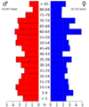
A population pyramid showing age groups in Appanoose County.


See also
 In Spanish: Condado de Appanoose para niños
