
Asotin County, Washington facts for kids
Quick facts for kids
Asotin County
|
|
|---|---|

Asotin County Courthouse
|
|

Location within the U.S. state of Washington
|
|
 Washington's location within the U.S. |
|
| Country | |
| State | |
| Founded | October 27, 1883 |
| Named for | Asotin Creek |
| Seat | Asotin |
| Largest city | Clarkston |
| Area | |
| • Total | 641 sq mi (1,660 km2) |
| • Land | 636 sq mi (1,650 km2) |
| • Water | 4.4 sq mi (11 km2) 0.7%% |
| Population
(2020)
|
|
| • Total | 22,285 |
| • Estimate
(2023)
|
22,549 |
| • Density | 35/sq mi (14/km2) |
| Time zone | UTC−8 (Pacific) |
| • Summer (DST) | UTC−7 (PDT) |
| Congressional district | 5th |
Asotin County is a county located in the very southeastern part of Washington state. In 2020, about 22,285 people lived there. The main town, or "county seat," is Asotin. The biggest city in the county is Clarkston.
Asotin County was created in 1883 from part of Garfield County. Its name comes from a Nez Perce word that means "Eel Creek." Asotin County is part of a larger area called the Lewiston–Clarkston metropolitan area. This area includes Nez Perce County, Idaho, which is just across the border.
Contents
History
In the early 1800s, both Americans and Canadians began to settle in the area that would become Washington state. Canadians were mostly interested in the fur trade. Americans wanted land for farming and raising animals.
The Treaty of 1818 said that both the U.S. and Canadian governments would share control of this land. This shared control caused many arguments. In 1846, the Oregon Treaty finally settled things. It gave the land south of 49 degrees North latitude to American control.

After this, new counties were formed. In 1854, Skamania County was made from the original Clark County. Later that year, Walla Walla County was created. Then, Columbia County was formed in 1875. In 1881, part of Columbia County became Garfield County.
Finally, in 1883, the southeastern part of Garfield County was separated to create Asotin County. The borders of Asotin County have stayed the same ever since. In 1862, a person named Bob Bracken became the first European settler to live permanently in what is now Asotin County.
Geography
Asotin County covers about 641 square miles. Most of this (636 square miles) is land, and a small part (4.4 square miles) is water. It is the fifth-smallest county in Washington by size. The county is part of the Palouse, which is a large, rolling grassland area in the middle of the Columbia basin.
Geographic features
Major highways
- U.S. Route 12

Adjacent counties
- Whitman County – to the north
- Nez Perce County, Idaho – to the east
- Wallowa County, Oregon – to the south
- Garfield County – to the west
National protected area
- Umatilla National Forest (part of it is in Asotin County)
Communities
Cities
Extinct towns
Census-designated places
Unincorporated communities
Demographics
| Historical population | |||
|---|---|---|---|
| Census | Pop. | %± | |
| 1890 | 1,580 | — | |
| 1900 | 3,366 | 113.0% | |
| 1910 | 5,831 | 73.2% | |
| 1920 | 6,539 | 12.1% | |
| 1930 | 8,136 | 24.4% | |
| 1940 | 8,365 | 2.8% | |
| 1950 | 10,878 | 30.0% | |
| 1960 | 12,909 | 18.7% | |
| 1970 | 13,799 | 6.9% | |
| 1980 | 16,823 | 21.9% | |
| 1990 | 17,605 | 4.6% | |
| 2000 | 20,551 | 16.7% | |
| 2010 | 21,623 | 5.2% | |
| 2020 | 22,285 | 3.1% | |
| 2023 (est.) | 22,549 | 4.3% | |
| U.S. Decennial Census 1790–1960 1900–1990 1990–2000 2010–2020 |
|||
What the 2010 Census Showed
In 2010, there were 21,623 people living in Asotin County. There were 9,236 households, which are groups of people living together. The population density was about 34 people per square mile.
Most people in the county (94.3%) were white. Other groups included American Indian (1.4%), Asian (0.5%), and Black or African American (0.4%). About 3.0% of the people were of Hispanic or Latino background. Many people had German, Irish, or English family roots.
About 27.7% of households had children under 18 living with them. The average household had 2.32 people. The average age of people in the county was 43.5 years old.
The average income for a household was about $41,665. For families, it was about $52,250. About 13.5% of all people in the county lived below the poverty line. This included 21.1% of those under 18 years old.
Gallery
-
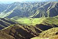
Joseph Canyon as seen from Fields Spring State Park


See also
 In Spanish: Condado de Asotin para niños
