
Ayent facts for kids
Quick facts for kids
Ayent
|
||
|---|---|---|

Anzere village
|
||
|
||

Ayent
Location in Switzerland

Ayent
Location in Canton of Valais
|
||
| Country | Switzerland | |
| Canton | Valais | |
| District | Hérens | |
| Area | ||
| • Total | 55.26 km2 (21.34 sq mi) | |
| Elevation | 967 m (3,173 ft) | |
| Highest elevation
(Wildhorn)
|
3,247 m (10,653 ft) | |
| Lowest elevation
(hameau de la Maya)
|
508 m (1,667 ft) | |
| Population
(Dec 2020 )
|
||
| • Total | 4,137 | |
| • Density | 74.864/km2 (193.90/sq mi) | |
| Postal code |
1966
|
|
| Localities | Botyre, Luc, Saxonne, La Place, Blignou, Fortunau, Saint-Romain, Signèse, Villa, Argnou, Anzère | |
| Surrounded by | Arbaz, Grimisuat, Icogne, Lauenen (BE), Lenk im Simmental (BE), Saint-Léonard, Savièse, Sion | |
| Twin towns | Saint-Brévin-les-Pins (France) | |

Ayent is a town, also called a municipality, in the Valais area of Switzerland. It is part of the Hérens district.
Contents
History of Ayent
The area of Ayent was first mentioned in old records in 1052. Back then, it was known as Agent. Later, in 1250, its name was written as Argenta.
Geography of Ayent
Ayent covers an area of about 55.1 square kilometers (21.3 square miles). A big part of this land, about 18.9%, is used for farming. Forests cover another 24.2% of the area.
About 4.6% of Ayent's land has buildings or roads. A small part, 1.4%, is covered by rivers or lakes. More than half of the land, about 50.7%, is unproductive. This means it's not used for farming or buildings.
Most of the built-up area is for homes and other buildings. Roads and transport take up a smaller part. In the forests, most trees are dense. Some areas have small groups of trees or orchards.
For farming, some land is used for crops. Other parts are pastures for animals. There are also areas for fruit trees or vineyards. High mountain pastures are also used for grazing.
A small amount of water in Ayent is in lakes. Even less is in rivers and streams. The unproductive areas include rocky land and glaciers. Some parts have plants that don't grow well.
Ayent is located on a high, flat area next to the Rhone river. It includes several villages and small settlements. Some of these are Botyre, Luc, and Saint-Romain. The popular tourist spot of Anzère was built here in 1969. Interestingly, there is no main village called Ayent within the municipality itself.
The Lac de Tseuzier is a large lake that acts as a reservoir. It is located on the border of Ayent with the town of Icogne.
Ayent's Coat of Arms
A blazon is a special description of a coat of arms. Ayent's coat of arms shows a golden lion standing on its back legs. It has a red tongue and claws. The lion is holding a silver sword. All of this is set against a blue background.
People of Ayent (Demographics)
As of 2008, Ayent had a population of 3,516 people. About 10.6% of these people were foreign nationals. Over ten years, from 1999 to 2009, the population grew by 11.6%. This growth was mostly because more people moved into Ayent.
Most people in Ayent speak French. In 2000, about 93.6% of the population spoke French as their main language. German was the second most common language, spoken by 2.8% of people. Portuguese was third, spoken by 1.4%.
In 2008, the population was almost evenly split between men and women. About 49.7% were men and 50.3% were women. Most people living in Ayent in 2000 were born there. Others were born in the same canton or elsewhere in Switzerland. Some people were born outside Switzerland.
The age groups in 2000 were:
- Children and teenagers (0–19 years old): 20.9%
- Adults (20–64 years old): 60.5%
- Seniors (over 64 years old): 18.6%
In 2000, there were 1,210 households in Ayent. The average household had 2.4 people. About 25.5% of households had only one person. Some households had five or more people.
Most of the buildings in Ayent are single-family homes. In 2000, these made up 70.1% of all inhabited buildings. There were also many multi-family buildings.
Economy of Ayent
In 2010, Ayent had an unemployment rate of 4.8%. This means 4.8% of people looking for jobs could not find one.
The economy is divided into three main parts:
- Primary sector: This includes jobs like farming and forestry. In 2008, 121 people worked in this sector.
- Secondary sector: This includes jobs in manufacturing and construction. In 2008, 208 people worked here.
- Tertiary sector: This includes jobs in services, like shops, hotels, and healthcare. In 2008, 478 people worked in this sector.
In total, 1,499 people in Ayent had jobs in 2008. About 42.6% of these workers were women.
Many people who live in Ayent travel to other towns for work. In 2000, 855 workers left Ayent for their jobs. Only 187 workers came into Ayent for work. This means more people leave Ayent to work than come in. Most people (77.2%) used a private car to get to work. About 8.2% used public transport.
Religion in Ayent
Based on the 2000 census, most people in Ayent are Roman Catholic. About 86.4% of the population belonged to this church. The Swiss Reformed Church was the second largest group, with 4.7% of the population.
A small number of people belonged to other Christian churches. There were also some people who were Islamic, Buddhist, or Hindu. About 4.4% of the population did not belong to any church.
Education in Ayent
Many people in Ayent have completed higher education. In 2000, about 33.5% of the population had finished upper secondary education. This is like high school. Another 10.0% had completed even higher education, such as university.
In 2000, only 4 students from other towns came to Ayent for school. However, 92 students from Ayent went to schools outside the municipality.
Ayent has a public and school library called Bibliothèque communale et scolaire. In 2008, the library had over 10,332 books and other items. It loaned out 28,200 items that year. The library was open 260 days a year, for about 22 hours each week.
Images for kids
-
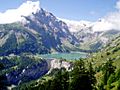
Lac de Tseuzier
-
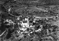
Aerial view of Ayent (1955)
-
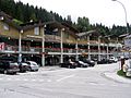
Anzere downtown
-
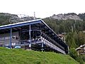
Cable car at Anzere


See also
 In Spanish: Ayent para niños
