Bainbridge, New York facts for kids
Quick facts for kids
Bainbridge, New York
|
|
|---|---|
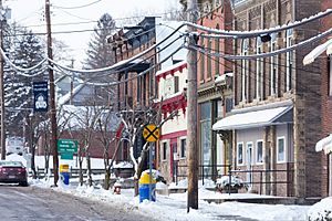
Center of town
|
|
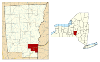
Location of Bainbridge in Chenango County
|
|
| Country | United States |
| State | New York |
| County | Chenango |
| Government | |
| • Type | Town Council |
| Area | |
| • Total | 34.76 sq mi (90.02 km2) |
| • Land | 34.31 sq mi (88.86 km2) |
| • Water | 0.45 sq mi (1.16 km2) |
| Elevation | 1,006 ft (307 m) |
| Population
(2010)
|
|
| • Total | 3,308 |
| • Estimate
(2016)
|
3,226 |
| • Density | 94.03/sq mi (36.31/km2) |
| Time zone | Eastern (EST) |
| ZIP code |
13733
|
| FIPS code | 36-017-04044 |
Bainbridge is a town in Chenango County, New York, United States. About 3,300 people lived there in 2010. It is on the eastern edge of Chenango County, located between the cities of Binghamton and Oneonta.
The small Village of Bainbridge is right in the middle of the town.
Contents
Exploring Bainbridge's Past: A Look at Its History
Long ago, Native American tribes from the Iroquois nations lived in the Bainbridge area. During the American Revolutionary War, these tribes joined forces with the British. They started attacking American settlements.
In 1779, George Washington sent the Sullivan Expedition into what is now Upstate New York. When General James Clinton reached the Bainbridge area, the tribes had already left. They found safety in Upper Canada. Clinton's soldiers destroyed their homes and food supplies for winter.
European Americans first settled the town around 1788. The first group was called the "Vermont Sufferers." These were people who had lost their land claims in Eastern New York. This happened because Vermont had sold the same land to other people.
The town was first created in 1791 as the "Town of Jericho." It was part of Tioga County before Chenango County was formed. In 1814, the name was changed to Bainbridge. This was to honor William Bainbridge, a famous United States Navy Commodore. Over time, parts of Bainbridge were used to create other towns. These included Norwich, Oxford, Greene, and Afton.
Understanding Bainbridge's Location and Landscape
The town of Bainbridge covers about 34.76 square miles (90.0 square kilometers). Most of this area is land, about 34.31 square miles (88.9 square kilometers). The rest, about 0.45 square miles (1.1 square kilometers), is water. The Susquehanna River flows right through the middle of the town. It enters from the east and leaves towards the south.
The eastern edge of Bainbridge is also the border of Delaware County.
Interstate 88, a major highway, goes through the town. It follows the path of the Susquehanna River. New York State Route 206 meets I-88 and New York State Route 7 in Bainbridge village. In 2007, a traffic circle was built. This helped traffic flow where County Route 39 and State Route 206 meet. A new bridge over the Susquehanna River was also finished in 2007. It replaced an older metal bridge.
Who Lives in Bainbridge? A Look at the Population
| Historical population | |||
|---|---|---|---|
| Census | Pop. | %± | |
| 1820 | 2,290 | — | |
| 1830 | 3,040 | 32.8% | |
| 1840 | 3,324 | 9.3% | |
| 1850 | 3,338 | 0.4% | |
| 1860 | 1,588 | −52.4% | |
| 1870 | 1,793 | 12.9% | |
| 1880 | 1,924 | 7.3% | |
| 1890 | 2,117 | 10.0% | |
| 1900 | 1,991 | −6.0% | |
| 1910 | 2,017 | 1.3% | |
| 1920 | 2,009 | −0.4% | |
| 1930 | 2,192 | 9.1% | |
| 1940 | 2,410 | 9.9% | |
| 1950 | 2,706 | 12.3% | |
| 1960 | 3,177 | 17.4% | |
| 1970 | 3,370 | 6.1% | |
| 1980 | 3,331 | −1.2% | |
| 1990 | 3,445 | 3.4% | |
| 2000 | 3,401 | −1.3% | |
| 2010 | 3,308 | −2.7% | |
| 2016 (est.) | 3,226 | −2.5% | |
| U.S. Decennial Census | |||
In 2000, there were 3,401 people living in Bainbridge. There were 1,368 households, which are groups of people living together. About 928 of these were families. The population density was about 99 people per square mile.
About 31% of households had children under 18. Over half, 54.8%, were married couples. The average household had 2.48 people. The average family had 2.99 people.
The median age in the town was 39 years old. This means half the people were younger than 39 and half were older. About 26.1% of the population was under 18. About 14.4% were 65 or older.
Communities and Places in Bainbridge Town
- Bainbridge – This village is where NY-7 and NY-206 meet by the Susquehanna River.
- Bennettsville – This is a small community near the eastern town line. It is in the southeastern part of the town on NY-206.
- Sidney Municipal Airport (N23) – This airport is partly in Bainbridge. It is near the eastern town line, north of I-88.
- Union Valley – This community is in the northwestern corner of the town. It is north of West Bainbridge on County Road 17.
- West Bainbridge – This is a small community near the western town line on NY-206.
What is Bainbridge's Climate Like?
Bainbridge has a climate with big changes in temperature during the year. Summers are warm to hot, and often humid. Winters are cold, sometimes very cold. According to the Köppen Climate Classification system, Bainbridge has a humid continental climate. This is often called "Dfb" on climate maps.
Notable People from Bainbridge
- Jedediah Smith (1799-1831) – He was a famous American mountain man and explorer of the western United States.
See also
 In Spanish: Bainbridge (Nueva York) para niños
 | Kyle Baker |
 | Joseph Yoakum |
 | Laura Wheeler Waring |
 | Henry Ossawa Tanner |


